Impossible Maps of an Ice-Free Antarctica
For two thousand years Europe drew a continent in the far south that nobody had seen. When explorers finally reached Antarctica in 1820, a handful of those old maps looked like they had gotten its coastline right, ice and all missing. Here is the file, every claim wearing its evidence.
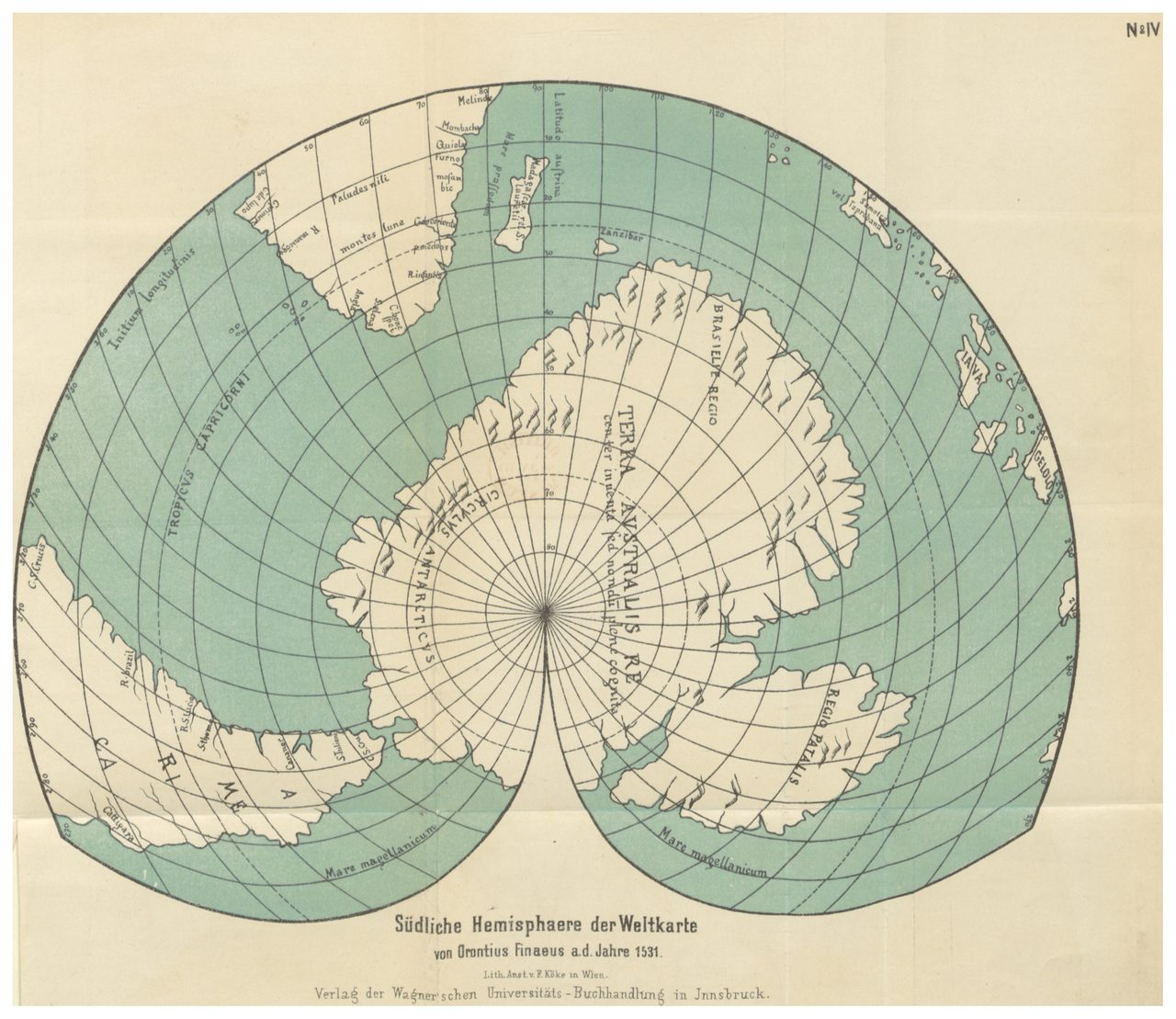
Here is a map drawn in 1531. Down at the bottom sits a southern continent, complete with rivers, forests, and named regions, nearly three centuries before any human being laid eyes on Antarctica. To some, that one detail is proof that someone charted the far south while it was still free of ice, and that our history is missing a chapter. To a cartographer, the truth is stranger and more ordinary at the same time. Let's open the file from the bottom up.
01The continent everyone drew before anyone saw it
The strange part is not that old maps show a land in the far south. Almost all of them do. Europe drew a southern continent for roughly two thousand years before anyone confirmed one was there, and it drew it for a reason that has nothing to do with exploration.
Western geographers, starting with Aristotle around 350 BCE, argued that a large southern landmass had to exist to balance the known continents of the north. They named this hypothetical land Terra Australis Incognita, the Unknown Southern Land, long before anyone could sail far enough to look for it.
By the Renaissance, Terra Australis had become a standard cartographic convention. It appeared on maps because the prevailing geographic theory demanded a balancing continent, not because any European had seen one. Different cartographers drew it with wildly different speculative shapes, sizes, and internal features, each filling the blank space with educated invention.
Antarctica was not actually discovered until January 1820, when three expeditions, led by Fabian von Bellingshausen for Russia, Edward Bransfield for Britain, and Nathaniel Palmer for the United States, independently sighted the Antarctic Peninsula or the continental ice shelf. Every map older than that predates the first confirmed human sighting of the continent.
| Map | The claim | What cartographers find |
|---|---|---|
| Piri Reis, 1513 | Its lower-left landmass is an ice-free Antarctic coast | A distorted continuation of the South American coast, swung eastward by a projection error (McIntosh, 2000) |
| Oronteus Finaeus, 1531 | Its southern land shows Antarctica before the ice | Conventional Terra Australis decoration needing no real geographic knowledge |
02The two maps everything hangs on
Out of the whole Renaissance map cabinet, the entire ice-free-Antarctica case rests on two documents: a 1513 chart by the Ottoman admiral Piri Reis, and a 1531 world map by the French mathematician Oronce Finé, usually Latinized as Oronteus Finaeus. Both show land in the far south. The only question that matters is whether that land is the memory of a real coast or a convention filling a gap.
In his 2000 cartographic study 'The Piri Reis Map of 1513,' Gregory C. McIntosh concluded that the map's disputed lower-left landmass is better explained as a distorted continuation of the known South American coast. The Patagonian shoreline appears swung eastward, most likely because the parchment ran out of room or the projection warped, not because it records a southern continent at all.
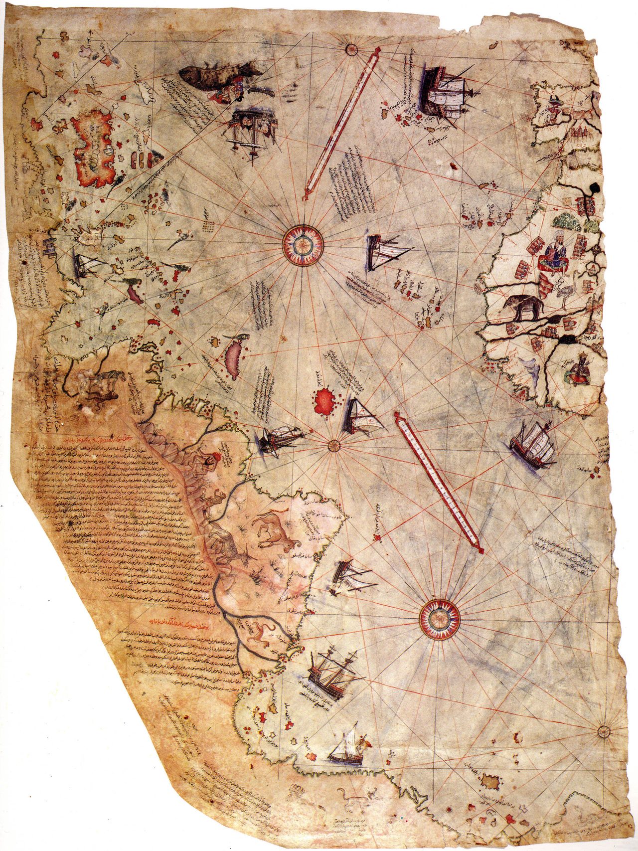
Piri Reis left his own note on the matter. He annotated the 1513 map to say it was compiled from earlier Portuguese and Spanish charts of the Atlantic. By his own account there was no ancient, ice-free-Antarctic source map anywhere in his materials, only the working charts of the explorers who came just before him.
The Oronteus Finaeus map fares no better under scrutiny. When its southern landmass is overlaid on a modern map using rigorous cartographic projection, the correspondence to actual Antarctic geography breaks down significantly. Its rivers, forests, and named regions are exactly the kind of conventional Terra Australis decoration that requires no real knowledge of the coast buried under the ice.
There is one honest oddity worth admitting. The Oronteus Finaeus southern landmass is roughly circular and centered on the South Pole, which does match the gross shape of the real Antarctica, unlike most Renaissance depictions that draw it elongated or wedge-shaped. It is a striking coincidence. It is also the simplest possible guess for a continent wrapped around the bottom of the globe, which is exactly why it stops short of proving any real knowledge.
03What the ice actually says
Set the maps aside for a moment and ask the harder question: when, if ever, was there an ice-free Antarctic coast for anyone to map? The answer from geology is not close, and it is not gentle.
The Antarctic ice sheet has existed in some form for roughly 34 million years, since the Eocene-Oligocene boundary. The East Antarctic Ice Sheet in particular has been present continuously for about 14 million years. This is not a recent freeze that a lost people might have beaten to the coastline.
There has been no completely ice-free Antarctica within the roughly 300,000 years that Homo sapiens has existed, or anywhere close to it. For anyone to have mapped an ice-free coastline from life, the mapping would have to predate not just every known civilization but every known hominin, by millions of years.
04Hapgood's case, and the letter behind it
The modern version of this claim has one clear author. In 1966 a history-of-science professor named Charles Hapgood published 'Maps of the Ancient Sea Kings,' and almost everything said about Antarctic maps since traces back to it.
| Method | Who used it | What it found |
|---|---|---|
| Grid overlay, adjusting scale, rotation, and projection | Hapgood, 1966 | Reported real correspondence to Antarctic geography |
| Rigorous cartographic projection | McIntosh, Portinaro, Crone | Poor correspondence; the matches vanish without selective adjustment |
Hapgood's method was a grid comparison: he overlaid the historical maps onto modern projections and reported that several features on the old charts lined up with real Antarctic geography. It was a real technique, applied in earnest, and the correspondences he reported are the entire empirical basis of the claim.
Hapgood's reading was directly influenced by a July 6, 1960 letter from US Air Force Lt. Col. Harold Z. Ohlmeyer of the 8th Reconnaissance Technical Squadron. The letter stated that the lower portion of the Piri Reis map 'seems to represent the Princess Martha Coast of Queen Maud Land,' with 'the coastline having been mapped in an ice-free period.' That single military opinion became the story's most-quoted line.
That letter, though, is an informal service opinion, not a rigorous cartographic study. Ohlmeyer was a reconnaissance officer, not a historian of cartography, and no subsequent professional analysis has confirmed the coastline correspondence he asserted. It is a genuine document that has been asked to carry far more weight than it can bear.
Here is the honest center of the whole controversy. There is a genuine disagreement between Hapgood's grid-overlay method, which reported real correspondence, and the later professional analyses of McIntosh, Portinaro, and Crone, which consistently found poor correspondence and attributed the apparent matches to non-rigorous, after-the-fact adjustment of scale, rotation, and projection. That methodological dispute, not any settled fact, is what keeps the argument alive.
05The civilization that would have to exist
To make the maps mean what he wanted, Hapgood had to supply two things history does not: a source and a mechanism. Both are where the case leaves the ground.
Hapgood proposed that medieval and Renaissance cartographers had inherited highly accurate ancient source maps, drawn by an unknown civilization and passed down through Alexandria and Islamic scholarly traditions before reaching European mapmakers. No such source map has ever been found.
To explain how Antarctica could have been ice-free recently enough for anyone to map it, Hapgood proposed Earth crustal displacement, a rapid shifting of the entire crust over the mantle. Modern geology rejects it as a mechanism; the crust does not move that way.
Albert Einstein did write a foreword to Hapgood's earlier 1958 book 'Earth's Shifting Crust,' and it is frequently cited as an endorsement. It was not. Einstein expressed interest in crustal displacement as hypothetically possible while explicitly declining to call it proven.
Stacked up, Hapgood's source-map hypothesis needs three unsupported things to be true all at once: a mapping civilization that predates every known civilization, maps that survived thousands of years of copying intact, and a total absence of any other trace of that civilization anywhere else on Earth. Each is a stretch. Together they are a tower with no foundation.
06Where it falls apart
When the claim is checked against the two kinds of hard evidence that could actually settle it, the ground itself and the ice itself, it does not survive.
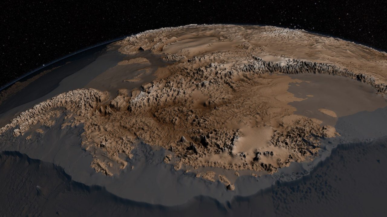
Modern radar surveys have mapped Antarctica's actual subglacial topography, the shape of the land beneath the ice. According to historians of cartography, that real coastline does not match what the Piri Reis and Oronteus Finaeus maps supposedly depict. They attribute the southern landmasses on early modern maps to the Terra Australis Incognita convention, not to any empirical survey of a coast.
The claim that these maps definitively show an ice-free Antarctica is not confirmed. Professional cartographic comparisons by McIntosh, Portinaro, and Crone have consistently found poor correspondence, and the apparent matches appear only when the overlay is adjusted for scale, rotation, and projection after the fact, which is to say only when the method is bent to produce them.
The stronger claim, that Antarctica was ice-free within recent human history, is not merely unproven but directly contradicted by geology. The ice sheet has been present continuously for at least 14 million years, no geological evidence supports any recent ice-free period, and Hapgood's crustal-displacement mechanism is unsupported by plate tectonics or geophysics. The physical record and the historical claim point in opposite directions.
One honest caveat about the scope of the case. The popular telling often reaches for more maps than these two, invoking others such as a 1737 Buache chart or Mercator's 1569 world map. Our file names them but does not substantively document either one, and neither carries a tested claim here, so we set them aside rather than lend them evidence they have not earned.
Fast Facts
- Subject
- The Piri Reis (1513) and Oronteus Finaeus (1531) world maps
- The claim
- They preserve an ice-free Antarctic coastline
- Antarctica discovered
- January 1820 (Bellingshausen, Bransfield, Palmer)
- Ice sheet age
- Roughly 34 million years; East Antarctic ice continuous about 14 million years
- Chief proponent
- Charles Hapgood, 'Maps of the Ancient Sea Kings' (1966)
- Proposed mechanism
- Earth crustal displacement (rejected by modern geology)
- Source confidence
- Low; a fringe claim, fairly documented
What the maps can actually tell us
The maps are real, and so is Terra Australis Incognita: a southern continent that Europe drew for two thousand years out of pure geometric theory, confirmed only in 1820. Land in the far south of an old map is expected, not anomalous.
There is a real methodological dispute between Hapgood's grid overlays and the professional cartographers who redid the work, and one genuine curiosity in the roughly circular, pole-centered shape of the Oronteus Finaeus landmass. Neither rises to proof, but neither is a fabrication.
The maps do not show an ice-free Antarctica, and Antarctica was not ice-free within human history. Radar mapping of the real coast disagrees, professional overlays find poor correspondence, and 14 million years of continuous ice contradict the whole premise. This one does not survive contact with the evidence.
Which leaves the one detail that refuses to sit down quietly: a map from 1531 with a southern continent that happens to be round, and happens to sit on the pole, in a century that had every reason to guess and no possible way to know. The simplest answer is that a lucky guess is still a guess. But it is exactly the kind of coincidence that will keep someone, somewhere, pulling the old charts back out. What would it actually take to tell a memory from a coincidence?
Sources & further reading
Everything above is drawn from our research library on Theories of Anything. Open the full files to check the sourcing and go deeper.
Image credits
- Oronteus Finaeus southern hemisphere, 1531 (1881 reproduction) photograph by Oronce Finé, via Wikimedia Commons. Public Domain Source.
- Piri Reis map, 1513 photograph by Piri Reis, via Wikimedia Commons. Public Domain Source.
- BEDMAP2 subglacial topography of Antarctica photograph by NSIDC / British Antarctic Survey, via Wikimedia Commons. CC BY 2.0 Source.
- Card crop of Oronteus Finaeus southern hemisphere, 1531 (1881 reproduction) photograph by Oronce Finé, via Wikimedia Commons. Public Domain Source.
_-_T4_-_S%C3%BCdliche_Hemisphaere_der_Weltkarte_des_Orontius_Finaeus_a._d._J._1531.jpg)

.jpg)