Atlantis: The Original Lost World
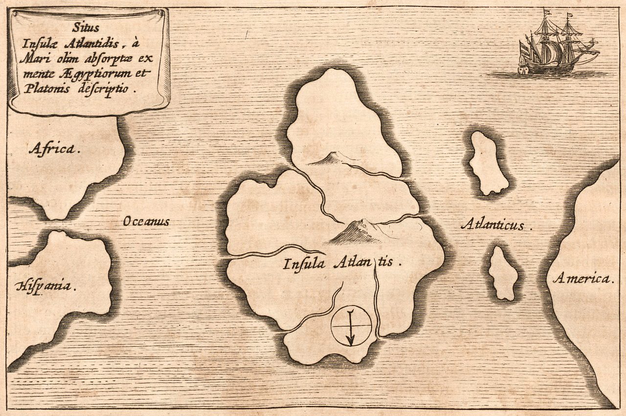
Around 360 BCE, Plato described an island empire beyond the Pillars of Heracles, larger than Libya and Asia together, that the gods drowned in a single day and a single night. It is the oldest lost world on record, and the mother of every one that followed. Most classicists think he invented it. Yet the story refuses to stay buried: it has been chased to a Saharan bullseye, a Greek volcano, the Antarctic ice, and a retracted Indonesian pyramid, and the date Plato gave for its fall lands squarely inside a real global catastrophe he had no way to know about, a real coincidence, not proof. Here is the file, opened claim by claim, every fact wearing its evidence.
Every lost world is measured against this one. Long before Lemuria, before Mu, before a single sonar ping went looking for a city on the seabed, an Athenian philosopher wrote down the story of an island empire that the gods drowned in a day. He gave it a size, a shape, a government, a fleet, and a date. Then he let the account break off in the middle of a sentence and never finished it. Nearly twenty-four centuries later we are still arguing about what he meant, still dragging the name across half the planet, and still, honestly, unable to close the case. Let us open the file.
01The Only Witness Is A Philosopher
Everything anyone knows about Atlantis traces to two texts by one man. Plato wrote the Timaeus and the Critias around 360 BCE, near the end of his life. The Timaeus introduces Atlantis in a brief, dramatic history that ends in its destruction. The Critias then doubles back to give the geography, the architecture, the culture, and the laws in lavish detail, and then stops, unfinished, breaking off in the middle of a sentence. There is no surviving inscription, no independently verified rival account, no Atlantean artifact ever recovered. Two dialogues, one author, and no confirmed corroboration from anywhere else.
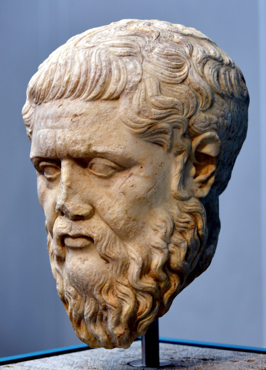
Plato does not present the tale as his own invention. He gives it a pedigree. Egyptian priests at the temple of Sais, he says, told the story to the Athenian statesman Solon when Solon traveled to Egypt around 590 BCE. Solon passed it to Dropides, who passed it to Critias the Elder, who passed it to Critias the Younger, the character who recites it to Plato's circle. The priests dated the events to some nine thousand years before Solon's visit, which puts the fall of Atlantis at roughly 9,600 BCE. Whether that chain is a real memory or a literary device that lends a made-up story an ancient passport is one of the oldest questions in the file.
The text goes out of its way to insist it is true. In the Timaeus the story is introduced as, in one common translation, 'not a myth but a true account.' Different translators word the line differently, but the narrator's claim is stable across all of them: this really happened. That the insistence is there, in Plato's own hand, is not in doubt. Whether to believe it is the entire argument.
02What Plato Said Atlantis Was
What follows is a faithful summary of the two dialogues. That Plato wrote these words is settled fact. Whether any of it describes a real place is exactly what the tiers are rating.
In the Timaeus, the Egyptian priest tells Solon that Athens itself once existed as a great civilization around 9,600 BCE. Beyond the Pillars of Heracles, the Strait of Gibraltar, lay an island 'larger than Libya and Asia combined.' From it a traveler could reach other islands, and from those, the 'opposite continent' that surrounded the 'true ocean.' The kings of Atlantis ruled the island and stretches of Libya as far as Egypt and of Europe as far as Tyrrhenia, and they launched an invasion that Athens alone stood against and defeated. Then came, in the text's own words, 'extraordinary earthquakes and floods,' and in a single day and a single night the island 'was swallowed up by the sea and vanished.' Afterward the sea in that place turned impassable, blocked by shoals of mud.
The Critias then fills in a level of detail that is startling for a supposed fable. A circular central island, about five stadia across, roughly 925 meters, ringed by three bands of water and two of land and joined to the sea by a great canal. A temple to Poseidon a stadion long, sheathed in silver with pinnacles of gold, holding a gold statue of the god driving six winged horses and encircled by a hundred Nereids on dolphins. Walls of red, white, and black stone. Tunnels cut to pass triremes between the rings. Elephants. And orichalcum, a metal the text calls second only to gold, sheathing the inner citadel, with the island's laws inscribed on an orichalcum pillar. Ten kings descended from Poseidon, a war machine of ten thousand chariots and twelve hundred ships, a climate mild enough for two harvests a year, and a slow moral rot as the founders' divine blood thinned across the generations into greed and empire. The account ends as Zeus gathers the gods to decide Atlantis's punishment. Mid-sentence, the manuscript stops.
One passage in the Timaeus has launched a thousand theories on its own. The 'other islands' have been read as the Caribbean, the Azores, or the Canaries; the 'opposite continent' as the Americas; the 'true ocean' as the Pacific, which the Americas and Asia really do enclose. If an Egyptian source in 360 BCE was somehow describing the layout of the Western Hemisphere, that would be a genuine puzzle about pre-Columbian geographic knowledge. It is also exactly the kind of pattern a reader can find in a vague ancient sentence when they already believe it is there. Our own file on impossible cartography takes up that thread.
| Feature | What The Text Says |
|---|---|
| Written | Timaeus and Critias, around 360 BCE |
| Location | Beyond the Pillars of Heracles (Gibraltar) |
| Size | 'Larger than Libya and Asia combined' |
| Central Island | About 5 stadia across (roughly 925 m), set in concentric rings |
| Signature Metal | Orichalcum, 'second only to gold' |
| Government | Ten kings descended from Poseidon |
| Military | 10,000 chariots and 1,200 ships |
| Date Of Fall | Roughly 9,600 BCE, in a single day and night |
03The Date That Should Not Line Up
Here is the detail that keeps serious people awake. Plato's date for the destruction, around 9,600 BCE, falls inside the Younger Dryas, a real and abrupt cold snap that gripped the planet from roughly 12,800 to 11,600 years ago. The end of the Younger Dryas, around 9,700 to 9,500 BCE, brought enormous pulses of glacial meltwater and catastrophic flooding as the ice age finally broke. It is the same window in which the builders of Gobekli Tepe were raising the oldest monumental architecture we know of, around 9,500 BCE. Plato could not have known any of this. The Younger Dryas was not identified by science until the twentieth century. Whatever else the date is, it is not something he could have reverse engineered to match a catastrophe no one would rediscover for more than two thousand years. It is a genuine and unexplained alignment. It is also, still, only a coincidence.
04Fiction, Or Memory? The Argument Never Settled
You will sometimes read that there is no real scholarly dispute about Atlantis. That is simply false. Whether Plato reported something or invented it is one of the most argued questions in all of classical studies, and it has been for centuries. The honest way to show it is to lay both cases side by side.
| Reasons To Read It As Fiction | Reasons To Read It As History |
|---|---|
| The dialogue is a teaching tool, and Atlantis is a moral lesson about hubris and imperial overreach. | The narrator flatly calls it 'a true account,' not a myth (Timaeus 26e). |
| No independent source confirms it. | Crantor claimed he checked the story in person with the priests at Sais, and other ancient writers mention islands in the western ocean. |
| The design is too neat: perfect rings and tidy round numbers. | Egyptian architecture really was rigidly geometric, so the regularity may reflect a real plan rather than invention. |
| Aristotle reportedly quipped that 'he who invented it also destroyed it.' | That line is poorly attested and may never have been said. |
| A moral fable needs no ring diameters, troop counts, or construction materials. | So why include them, along with a date that lands on a real catastrophe and an ending left unfinished, which is a strange way to plan a fable? |
For all that, one side is currently winning. Among classicists and historians of ancient philosophy, the majority position today is that Atlantis is Plato's own literary invention: a fictional narrative dressed in the costume of history to drive home a philosophical point about a proud empire and an ideal state. The historical-basis reading has real defenders, and the arguments above are not nothing, but it is the minority view. Naming that plainly matters more than pretending the question is settled either way.
05The Story Before Plato, And The Doubts After
Plato did not write into a vacuum. The idea of a marvelous, doomed land in the western sea was already old. Homer, some three and a half centuries before Plato, sang of the Phaeacians, master seafarers on the island of Scheria whose ships steered themselves and whose kings carried divine blood. Hesiod, around the same time, placed the 'Isles of the Blessed' out in the western ocean. Egyptian records themselves speak of 'Western Lands' and of the Hau-Nebut, the 'people of the islands.' Atlantis arrived into a Mediterranean imagination that already half expected something out past the edge of the map.
The story kept gathering witnesses after Plato too, though not all of them believed it. Aristotle, Plato's own student, is the earliest reported skeptic, with that possibly apocryphal line about the man who invented Atlantis destroying it. But Crantor, around 300 BCE and Plato's first commentator, claimed to have verified the account with the priests at Sais, who he said showed him the story inscribed on columns; Proclus, centuries later, reports Crantor's visit. Diodorus Siculus, in the first century BCE, wrote of the Atlantioi, a people of the Atlas mountains invaded by the Amazons. The ancient world did not agree on whether Atlantis was real. It simply refused to forget it.
06Six Places That Claim The Name
If Atlantis was a real place, it should be somewhere. For centuries people have been pointing at the map, and the candidates have only multiplied. Six of them are worth weighing, and each fails a different test. Here they are, in the order this file works through them, with what is actually known about each.
The Richat Structure, on the Adrar Plateau of Mauritania, is the candidate that looks the part. From the air it is a bullseye of concentric rings, forty to fifty kilometers across, with an inner ring measuring about 23.5 kilometers. That number is the hook. In 2018 the YouTuber Jimmy Corsetti, of the channel Bright Insight, pointed out that Plato's stated 127 stadia works out to almost exactly 23.5 kilometers, and called it a perfect match. The physical facts underneath the theory are real and strange. Satellite radar has confirmed a vast ancient river system, the Tamrasett, that once crossed the Sahara and emptied into the Atlantic near the Richat, and salt deposits in the soil point to a time when seawater reached the area. During the African Humid Period the Sahara was green, and the ice-age coastline sat far closer than it does now.
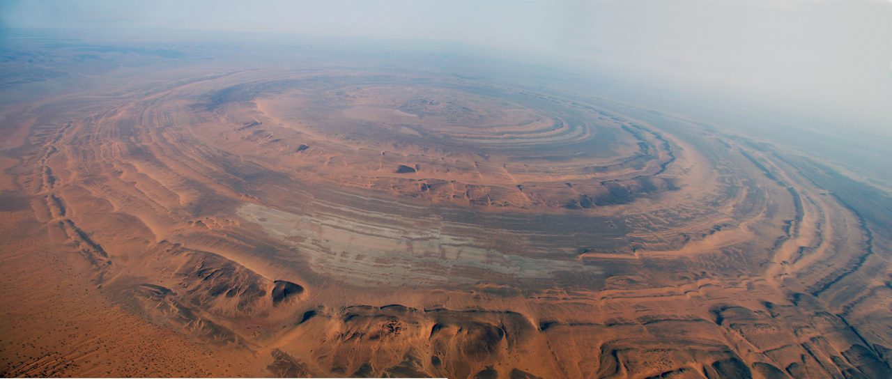
And then the theory hits the ground. The Richat Structure is not underwater and never was during any time Atlantis could plausibly have existed. It sits about 400 meters above sea level and hundreds of miles inland. Geologists do not see a drowned city; they see a domed anticline roughly 100 million years old, laid bare by erosion, its rings the exposed edges of tilted rock layers. Surveys of the site have turned up stone-age tools and nothing else. No harbor, no canal cut by human hands, no wall, no metal, no sign of a Bronze-Age city of any kind. It is a spectacular natural formation that happens to be round.
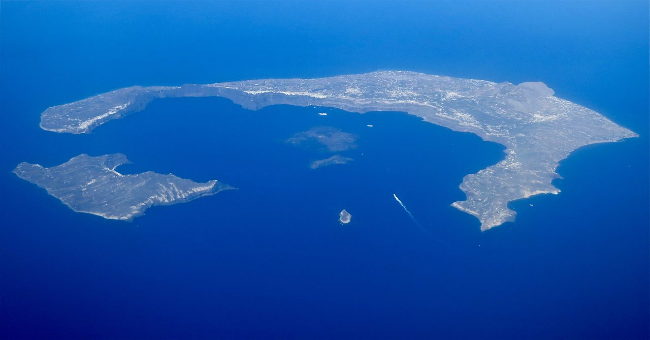
Santorini is the candidate with a real civilization behind it. Around 1600 BCE the volcanic island of Thera erupted catastrophically and helped destroy the Minoans, the most advanced maritime culture of the Bronze Age Aegean, and the flooded caldera it left behind does look strikingly like a great circular harbor. Galanopoulos laid out the case in 1969, and as lost advanced civilizations drowned by the sea go, this is the best documented one on the list. The trouble is that it matches Plato on almost nothing else. Wrong ocean: Thera sits in the Mediterranean, and Plato is explicit that Atlantis lay beyond the Pillars of Heracles. Wrong date: 1600 BCE, not 9,600. Wrong scale: the Atlantis of the text is vastly larger. The strongest real-world candidate is still the wrong place at the wrong time.
Antarctica is the candidate that requires the whole planet to move. Rand and Rose Flem-Ath, in When the Sky Fell (1995), building on Charles Hapgood, proposed that Atlantis lies frozen under the Antarctic ice, carried to the pole by 'crustal displacement,' a sudden slippage of the Earth's entire crust. They point to old maps some read as showing an ice-free Antarctica and to the continent's Atlantis-like size. The problem is the mechanism. Mainstream geology rejects crustal displacement outright, and the Antarctic ice sheet is on the order of 34 million years old, though some coastal fringes may have thawed more recently. To put a city there in human times, you have to rewrite geophysics first.
Sundaland is the candidate that gets the drowning right and the direction wrong. During the last ice age, with sea levels about 120 meters lower, a huge habitable landmass joined what is now Indonesia, Malaysia, and the Philippines, and the rising post-glacial seas swallowed it, the largest loss of land in the human era. Arysio Nunes dos Santos and Stephen Oppenheimer have argued it was the real Atlantis. Geologically the drowned continent is entirely real. But it lies southeast of Egypt, and Plato is specific: Atlantis was beyond the Pillars of Heracles, to the west, out in the Atlantic. Sundaland is a genuine lost world pointing the wrong way down the compass.
The Bimini Road is the candidate that has actually been tested, and it failed. Off North Bimini in the Bahamas lies a line of rectangular limestone blocks, found in 1968 and quickly hailed as an Atlantean road or wall. Geologist Eugene Shinn studied them directly. They are beachrock: a natural sedimentary stone that fractures into neat, block-like segments along its bedding planes. Core samples show the internal layering running continuously in the orientation of an ocean floor, not the cross-cut faces of quarried stone, and radiocarbon dates on associated shells come back at just 2,000 to 4,000 years old, far too young for anything Plato described. The blocks are real. The road is not.
Gunung Padang, a genuine megalithic site in West Java, briefly looked like the strongest physical evidence of all. In a 2023 paper in the journal Archaeological Prospection, Danny Hilman Natawidjaja and colleagues reported that layers buried deep beneath the visible terraces carbon-dated to between 25,000 and 14,000 BCE, which would make the site the oldest pyramid on Earth by a staggering margin, and some tied it to a drowned Sundaland. Mainstream archaeologists pushed back hard, arguing the deep 'construction' was natural rock and soil and that the ancient carbon dates came from ordinary organic material in the ground, not from anything human.
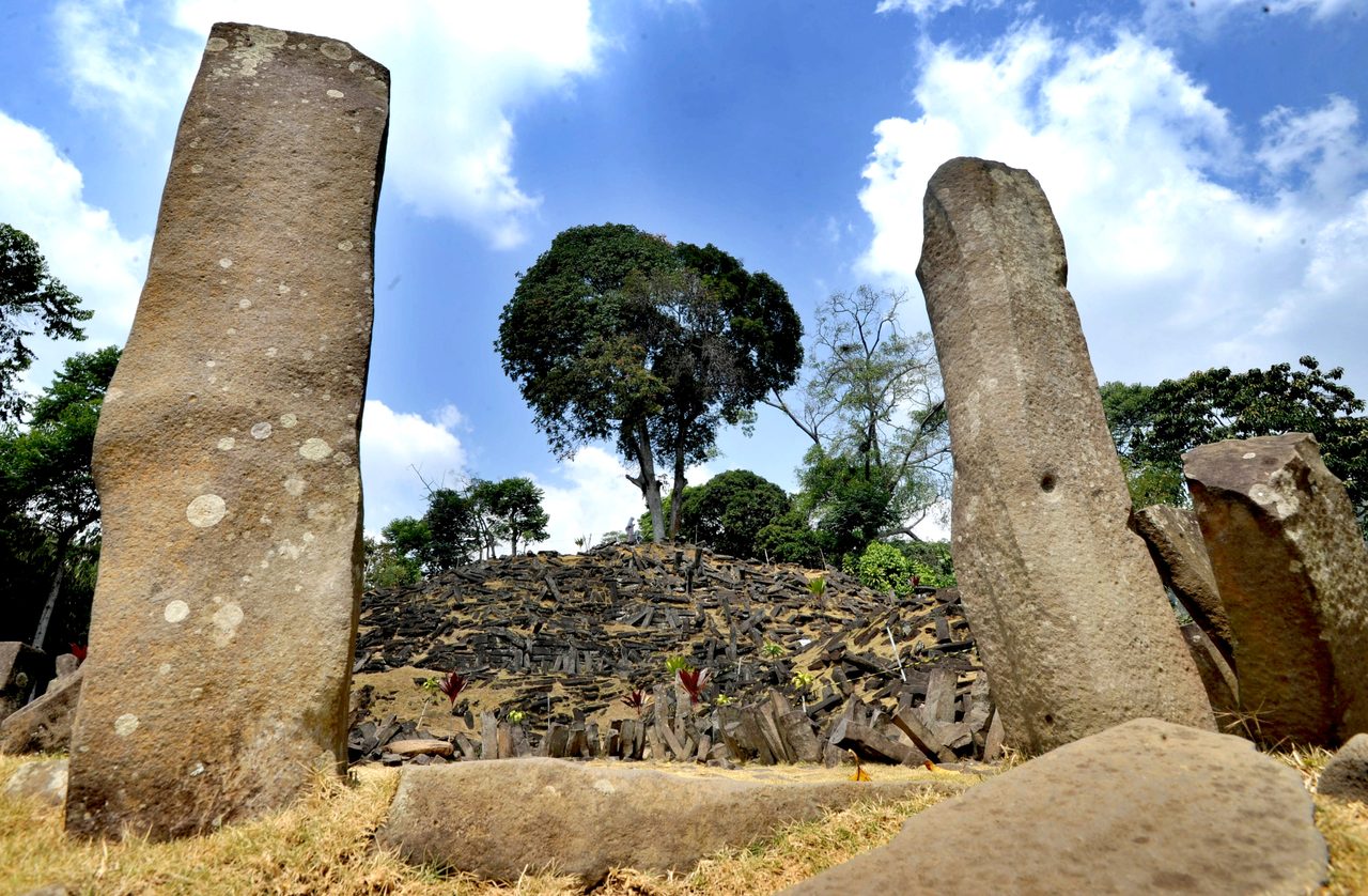
Then the paper was withdrawn. In March 2024, after roughly three months of scrutiny by outside experts in geophysics, archaeology, and radiocarbon dating, the journal's editors and its publisher, Wiley, retracted it. The retraction notice cited three failures: carbon dating of natural soil organics wrongly attributed to human activity, insufficient evidence that the deep layers were built at all, and irregularities in the peer review that let the paper through. No rebuttal has reversed it. The upper terraces of Gunung Padang are still real and still old, dated to roughly 2,000 to 5,000 BCE. It was only the twenty-five-thousand-year-old pyramid underneath them that dissolved on inspection.
| Candidate | Where And When | Evidence Tier | The Fatal Problem |
|---|---|---|---|
| Richat Structure | Mauritania, inland Sahara | Tier 2 to 3 | Never underwater; only stone-age tools; a natural eroded dome |
| Santorini / Thera | Aegean Sea, around 1600 BCE | Tier 2 | Wrong ocean, wrong date, too small; inside the Mediterranean |
| Antarctica | Under the polar ice cap | Tier 3 | Requires 'crustal displacement,' which geology rejects |
| Sundaland | Southeast Asian shelf | Tier 3 | A real drowned land, but east of Egypt, not west |
| Bimini Road | Bahamas | Tier 1 (debunked) | Natural beachrock, dated 2,000 to 4,000 years old |
| Gunung Padang | West Java | Tier 3 claim, Tier 1 retraction | The ancient-pyramid paper was retracted in 2024 |
07Doggerland: The Lost World That Is Actually Real
Here is the fact that should reframe the entire question. Lost worlds are not a fantasy genre. They are geologically ordinary, and one of them sits under the North Sea right now. Doggerland was a real, inhabited country spanning what is now the seabed between Britain, the Netherlands, Denmark, and Norway, as much as 260,000 square kilometers at its peak, larger than Great Britain. Mesolithic hunter-gatherers lived there from roughly 10,000 to 6,500 BCE, and we know because fishing trawlers keep hauling their tools, along with mammoth bones and human remains, up off the sea floor, while seismic surveys map its drowned rivers and settlements. It went under as the glaciers melted and the seas rose, with the final blow likely delivered by the Storegga Slide around 6200 BCE, an undersea landslide off Norway that threw up tsunami waves as high as 25 meters.
Doggerland is not Atlantis. The research this file draws on says so plainly: wrong place, wrong period, no match to Plato's description. But Doggerland proves the one thing the whole legend depends on. A populated land really can vanish beneath the waves inside the span of human memory, leaving its people to carry the story onward. The work is ongoing, from Vincent Gaffney's Europe's Lost World to the University of Bradford's Lost Frontiers project, which reads ancient DNA straight out of the seabed. Whatever Plato was or was not remembering, the raw phenomenon he described is real.
08One Atlantis, Or A Whole Drowned Network?
One way out of the six-failed-candidates problem is to stop looking for a single island. The Network Hypothesis proposes that 'Atlantis' was never one place but a shorthand for a whole web of connected maritime cultures, all erased together by the Younger Dryas catastrophe. Its backers, chiefly Graham Hancock and Randall Carlson, point to flood traditions on every inhabited continent, to what they read as identical precession-of-the-equinoxes numbers turning up in widely separated cultures, and to construction techniques that recur across sites an ocean apart.
Hancock has built this into a full narrative across two books, Fingerprints of the Gods (1995) and Magicians of the Gods (2015). In his telling, a sophisticated seafaring civilization mapped coastlines, raised megaliths, and encoded astronomical knowledge during the last ice age, and was then shattered by the Younger Dryas, roughly 12,800 to 11,600 years ago. The survivors scattered and reappeared in myth after myth as the 'knowledge givers' who taught farming, building, and the calendar to the peoples they reached: Oannes and the Apkallu in Sumer, Thoth in Egypt, Viracocha in the Andes, Quetzalcoatl in Mesoamerica, the Seven Rishis in India. Atlantis, in this reading, is simply Plato's name for the network that fell.
It is a sweeping idea, and it rests on a stack of individually contested pillars, each of which is its own file in our library: that the Younger Dryas catastrophe was real and abrupt, that Gobekli Tepe proves a capable culture already existed around 9,500 BCE, that more than five hundred flood stories worldwide share a common root, that certain ancient maps encode impossible geographic knowledge, that some megalithic engineering exceeds conventional explanation, and that the 'civilization bringer' who arrives after a flood is a genuinely universal figure. Some of those pillars are solid, others are shaky, and the synthesis is only ever as strong as its weakest one. That is why it stays speculative: not disproven, nowhere near proven, and asking the reader to accept a great deal at once.
Fast Facts
- Source
- Plato's Timaeus and Critias, around 360 BCE
- Claimed Location
- Beyond the Pillars of Heracles (Gibraltar)
- Claimed Date Of Fall
- Roughly 9,600 BCE, in a single day and night
- Real Event At That Date
- The Younger Dryas, a genuine global catastrophe
- Rival Locations
- Richat, Santorini, Antarctica, Sundaland, Bimini, Gunung Padang
- Best Real Candidate
- Santorini / Thera, and it still does not fit
- Debunked Or Retracted
- Bimini Road (beachrock); Gunung Padang pyramid claim (retracted 2024)
- Scholarly Consensus
- Most classicists read it as Plato's invention
What We Can Actually Stand Behind
The texts are real and say exactly what we have quoted. Plato wrote the Timaeus and Critias around 360 BCE. The Younger Dryas, the abrupt cold snap and meltwater catastrophe that gripped the planet as the last ice age broke, is itself a real, well-documented event. And lost worlds are not fantasy: Doggerland, an inhabited country larger than Great Britain, truly did drown under the North Sea within human memory. All of that is settled.
Whether Plato reported a real memory or built a brilliant fiction is a live scholarly argument, and today most classicists land on fiction, a philosophical fable about hubris wearing the clothes of history. The date coincidence is real and unexplained, and still only a coincidence. Among the places, Santorini is the strongest candidate and does not fit Plato's ocean or his date; the Richat Structure is spectacular and has yielded nothing but stone-age tools; Antarctica and Sundaland lean on rejected geology or the wrong direction. Nothing here has been proven.
No one has found Atlantis. The two candidates that claimed hard physical proof both fell apart: the Bimini Road is natural beachrock, dated thousands of years too young, and Gunung Padang's twenty-five-thousand-year-old pyramid was retracted by its own journal in 2024, its ancient dates traced to plain dirt. Not one wall, one artifact, or one surviving inscription anywhere on Earth has ever been tied to Plato's city.
So the oldest lost world stays exactly what it has always been: a story we cannot prove and cannot quite throw away. We can read every surviving word Plato wrote, walk all six of the places that borrow the name, and stand on the drowned floor of a country the sea really did take. The one thing we cannot do is close the file. If Plato invented Atlantis, why did he set its ending inside a real global catastrophe that no one on Earth would identify until the twentieth century? And if he did not invent it, where is the single stone that would finally prove him right?
Sources & further reading
Everything above is drawn from our research library on Theories of Anything, deep-read in full rather than skimmed. The corpus files are where we worked from; the papers and primary sources listed beneath them are where you can check us independently.
Image credits
- A 17th-century engraved map showing Atlantis as a large island in the Atlantic Ocean Engraving: Athanasius Kircher, Mundus Subterraneus. Public domain Source.
- A marble bust of the Greek philosopher Plato, a Roman copy of a Greek original Photo: Osama Shukir Muhammed Amin. CC BY-SA 4.0 Source.
- An aerial photograph of the Richat Structure in Mauritania Photo: DHQ (Wikimedia Commons). CC BY-SA 4.0 Source.
- An aerial view of the flooded volcanic caldera of Santorini Photo: Steve Jurvetson. CC BY 2.0 Source.
- The terraced stone platforms of the Gunung Padang megalithic site in West Java, Indonesia Photo: Arie Basuki. CC BY-SA 4.0 Source.
- Card crop of a 17th-century engraved map showing Atlantis as a large island Engraving: Athanasius Kircher, Mundus Subterraneus. Public domain Source.

_of_an_original_(350-340_BCE)._Altes_Museum,_Berlin.jpg)


