Derinkuyu: The 18-Story City Carved Straight Down
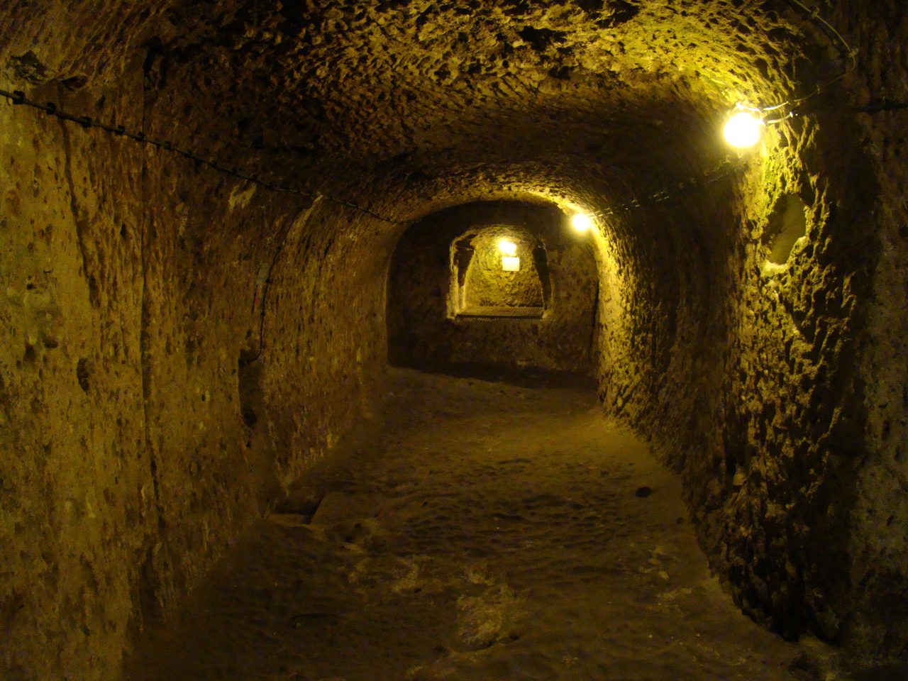
Under a town in central Turkey, someone cut a city eighteen levels deep, room for twenty thousand people and their cattle, sealed behind rolling stone doors of up to half a tonne that lock only from the inside. Here is the file, level by level, every claim wearing its evidence.
Almost every ancient wonder we brag about was built upward: pyramids, ziggurats, temples reaching for the sky. Derinkuyu was built the other way. Somewhere under a quiet town in central Turkey, people cut a city eighteen levels straight down into solid rock, deep enough to hide twenty thousand of them, their animals, and enough food and water to wait out an army. Then they carved doors they could only lock from the inside. Let's open the file.
| Measure | Figure |
|---|---|
| Depth | ≈ 85 m (280 ft) below the surface |
| Levels | 18 recognized, 8 excavated and open |
| Open floor area | ≈ 2,500 m² across those 8 levels |
| Shelter capacity | ≈ 20,000 people, plus livestock |
| Ventilation shafts | ≈ 52; the largest also a well |
| In the region | 200+ underground settlements |
01The city that goes the wrong way
Derinkuyu is the deepest known underground city in Cappadocia: roughly 85 meters (280 feet) straight down, across 18 recognized levels, of which 8 are fully excavated and open to visitors, about 2,500 square meters of accessible space. This is measured, mapped, published archaeology, not a tour guide's rounding up.
Picture a shaft of inhabited rock as tall as a 25 storey tower, pointed straight into the ground. And Derinkuyu is not a freak. It is one of more than 200 underground settlements catalogued across the Cappadocian region, an entire landscape that, at some point, learned to live downward.
02The rock that carves soft and sets hard
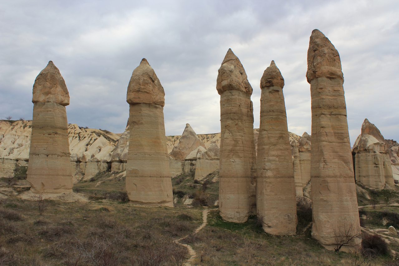
Cappadocia is what three volcanoes left behind. Erciyes Dağı, Hasan Dağı and Melendiz Dağı buried the region in ash between roughly 5 and 10 million years ago, and that ash consolidated into ignimbrite tuff, the pale, porous rock that erosion later sculpted into the region's famous fairy chimneys. The same rock runs deep underground, and that is the whole secret of the place.
Freshly exposed tuff is soft enough to cut with iron, or even copper and bronze, hand tools. Then it hardens as it dries and oxidises in contact with air. Carve it out while it is workable, and the walls you leave behind cure into stable, load bearing rock. It is close to the perfect medium for digging a city by hand.
The rock also holds a constant temperature. Cappadocian tuff stays around 13 to 15°C year round, while the surface swings from about -20°C in winter to 40°C in summer. Underground, food keeps, animals survive, and a population can wait out a season in comparative comfort.
03Doors that only lock from the inside
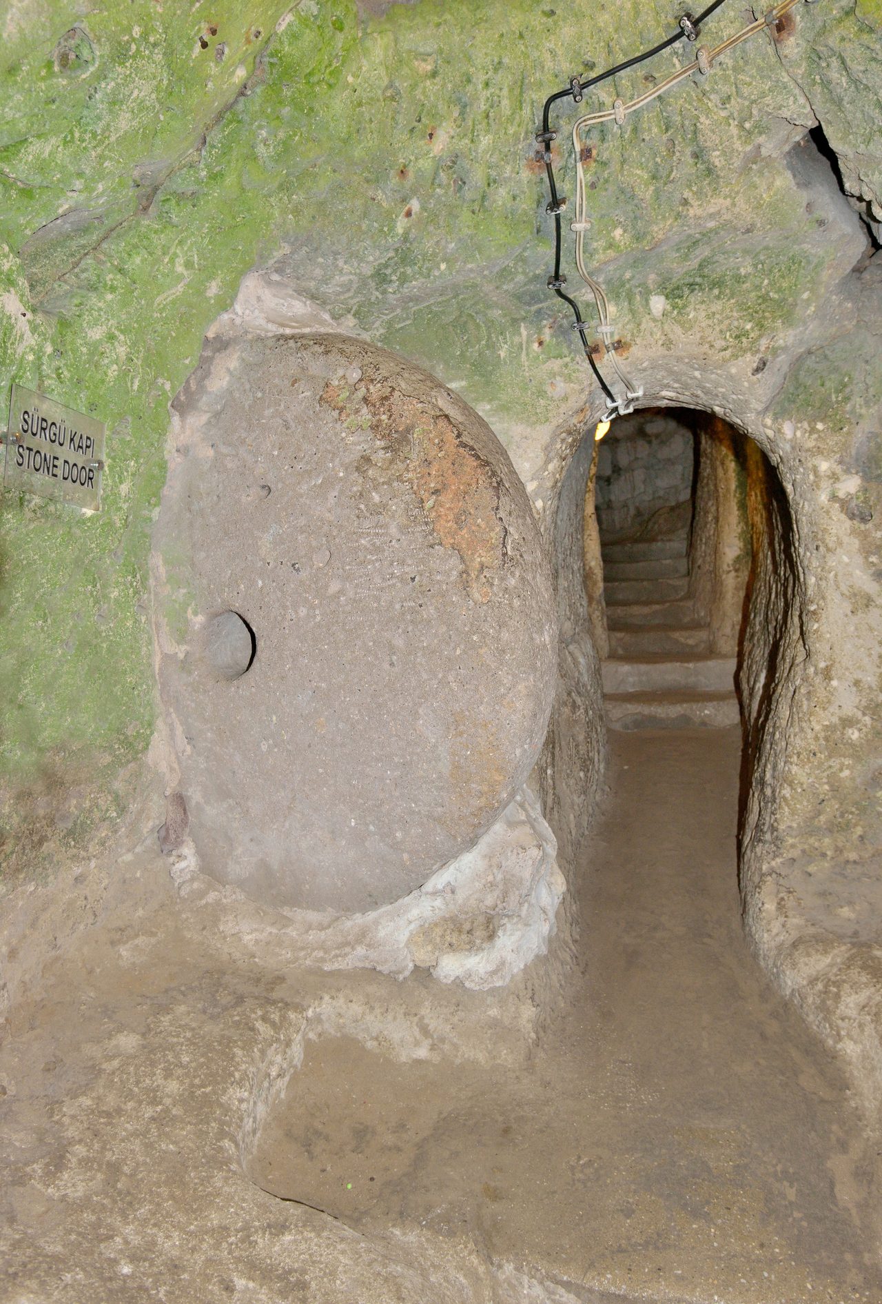
Derinkuyu's corridors were sealed with rolling stone doors: circular stone discs, roughly 1 to 1.5 meters across and weighing up to 500 kilograms, that could be rolled into a doorway from within and could not be shifted from the far side. Many have a hole bored through the centre, which may have let defenders thrust a spear at anyone trying to move them.
The doors were only the first layer. Passages between levels were cut narrow and deliberately awkward, forcing single file movement through sharp turns, so one defender at a chokepoint could hold off many. At nearby Özkonak, builders went further, adding holes between levels to pour hot oil down onto intruders and small slots to spear anyone pinned in the tunnels.
Every one of these features points the same direction. The engineering is defensive, built to let a whole population vanish underground, seal the entrances behind them, and outlast a siege they could never win on the surface.
04Not a panic room, a working city
A place built only to hide would have bare rooms. Derinkuyu has wine presses and oil presses cut into the rock, kitchens, storage rooms, schools, stables on the upper levels for the animals, and, about 60 meters down on the seventh level, a cross shaped Byzantine church complete with a missionary school and a baptismal font. People did not just shelter here. They lived here.
| Level / zone | What was carved there |
|---|---|
| Upper levels | Stables sized for livestock, mainly horses and cattle |
| Living zones | Living quarters, kitchens, storage rooms, schools |
| Production | Wine presses and oil presses, cut in place |
| 7th level (≈ 60 m) | A cruciform Byzantine church, missionary school, baptismal font |
| Throughout | ≈ 52 ventilation shafts; the largest also a well to the water table |
The air is the quiet miracle. Around 52 vertical shafts thread the whole complex, positioned to drive natural convection, the chimney effect, so fresh air reaches even the deepest levels with no machinery at all. It was good enough to keep thousands of people and their livestock breathing underground for extended stretches.
The water supply shows the same foresight. Wells were sunk to the water table and, crucially, kept separate for different levels, so an enemy who found and poisoned a well at the surface could not contaminate the water for everyone below.
The famous capacity of 20,000 people comes from measuring the excavated volume against known settlement densities. Read it as an emergency maximum, shoulder to shoulder in a crisis, rather than a comfortable permanent population, which was almost certainly far smaller.
| Period | Role in the story |
|---|---|
| Hittite era (c. 1400 to 1200 BCE) | Argued origin; texts and nearby sites hint, not proven |
| Phrygian (8th to 7th c. BCE) | Most common estimate for first digging |
| Early Christian / Byzantine (4th to 7th c. CE) | Documented great expansion and heavy use |
| Arab raids (7th to 10th c. CE) | Primary threat driving refuge use |
| Later Mongol incursions | Cities sheltered locals again |
05Who dug it, and when
So who cut it, and when? This is where honest archaeology has to shrug, because a space reworked and reoccupied for two thousand years is nearly impossible to date from the inside.
The most common scholarly estimate puts the first digging in the Phrygian period, the 8th to 7th centuries BCE. A number of researchers argue for older, Hittite era origins around 1400 to 1200 BCE, pointing to Hittite texts that mention underground cities in the region, Hittite settlements sitting right beside the entrances, and early pottery. None of it is decisive: stratigraphy in a continually re-carved cave is brutal to read.
What is best documented is the great expansion. Across the early Christian and Byzantine centuries, roughly the 4th to 7th CE, the cities were enlarged and heavily used as refuges, first from persecution and then from the Arab raids that swept into Byzantine Anatolia from the 7th century on. This was the Cappadocia of the great church fathers, Basil of Caesarea and the two Gregories, and the frescoed underground churches belong to that world.
Derinkuyu is reportedly linked to the underground city of Kaymakli, about 4 km away, by a tunnel some 9 kilometers long: in effect, a subway between two hidden towns. The two cities are real and well studied; the full connecting tunnel is reported rather than fully traced end to end.
06The deeper levels, and where it tips into fringe
Local reports and limited exploration suggest more levels lie below the 8 that are open, and geophysical surveys have picked up voids consistent with additional chambers. If that holds, the mapped city is only the part we have reached, not the whole of it.
A few researchers push the origins back further still, toward the Neolithic farming cultures of central Anatolia such as Çatalhöyük and Aşıklı Höyük. It is a plausible guess, but no definite Neolithic construction has ever been demonstrated at Derinkuyu itself.
And then there is the other kind of theory. Because the place is so deep, so old, and so strange, Derinkuyu gets folded into stories about ancient alien engineers, lost pre human super civilisations, and even entrances to a hollow earth.
There is nothing under any of it. No archaeological, geological, or engineering evidence supports alien builders, a vanished super civilisation, or a hollow earth beneath Cappadocia. Every tool mark, every technique, every feature is consistent with Bronze and Iron Age people working an unusually forgiving rock with hand tools. The awe is entirely earned. The aliens are not.
Fast Facts
- Site
- Derinkuyu, Nevşehir Province, Cappadocia, central Turkey
- Depth
- ≈ 85 m (280 ft), the deepest known Cappadocian city
- Levels
- 18 recognized, 8 open to visitors
- Capacity
- ≈ 20,000 people, plus livestock
- Defences
- Rolling stone doors up to 500 kg, sealed from the inside
- Ventilation
- ≈ 52 shafts; the largest doubles as a well
- Main use
- Refuge, expanded 4th to 7th centuries CE (Byzantine)
- In the region
- 200+ underground settlements catalogued
What we can actually stand behind
Derinkuyu is real, and it is extraordinary: a genuine city carved roughly 85 meters into volcanic rock, with ventilation, water, food production and defences good enough to hide 20,000 people from an army.
Exactly who first cut it, and when, is unsettled. Phrygian, around the 8th century BCE, is the common estimate; a Hittite origin centuries earlier is argued but unproven. The Byzantine era expansion, by contrast, is firmly documented.
Ancient aliens, a lost pre human civilisation, and hollow earth entrances all fail. Not because the site is ordinary, but because everything in it was made by human hands with human tools, and the workable rock explains the rest.
Which leaves the one question the surveys keep raising and cannot yet answer. If geophysics is reading empty rooms below the deepest floor anyone has walked, then Derinkuyu has never actually been seen to the bottom. How much further down does the city go, and who was the last person to roll a stone door shut behind them?
Sources & further reading
Everything above is drawn from our research library on Theories of Anything. Open the full files to check the sourcing and go deeper.
Image credits
- Interior of the Derinkuyu underground city photograph via Wikimedia Commons (Bjørn Christian Tørrissen). CC-BY-SA 3.0 (dual with GFDL 1.2+) Source.
- A circular rolling stone door (millstone-shaped disc) set in photograph via Wikimedia Commons (Wolfgang Moroder). CC-BY-SA 3.0 Source.
- Cappadocian surface landscape of fairy-chimney tuff rock photograph via Wikimedia Commons (Arian Zwegers (Brussels, Belgium)). CC-BY 2.0 Source.
- Card crop of Interior of the Derinkuyu underground city photograph via Wikimedia Commons (Bjørn Christian Tørrissen). CC-BY-SA 3.0 (dual with GFDL 1.2+) Source.


.jpg)