The Vinland, Zeno and Buache Map Controversies
Three disputed maps, each accused of knowing too much too early: a medieval world map with America on it, a Venetian chart of the far north, and a French map of a southern land that looks like Antarctica. Here is the file on all three, and every claim wears its evidence.
Some maps feel like they are keeping a secret. A coastline drawn a little too well, a landmass sitting where nobody of that era was meant to have sailed, a date that lands decades or even centuries too early. Three maps have carried exactly that charge for generations: the Vinland Map, the Zeno Map, and the Buache Map. Each has been offered, at one point or another, as proof that someone charted a piece of the world long before the history books say they could have. So let us open all three files, one at a time.
| Map | Published / surfaced | Where it stands now |
|---|---|---|
| Vinland Map | Surfaced 1957, published 1965 | 20th-century forgery on medieval parchment |
| Zeno Map | Venice, 1558 | Unreliable 16th-century fabrication |
| Buache Map | Paris, 1737 | Speculative Terra Australis cartography |
01The map that put America on parchment
The Vinland Map is the most famous of the three, and it is the one whose story is now, at last, closed. For a stretch of the 20th century it looked like it might be the single most important map in the world.
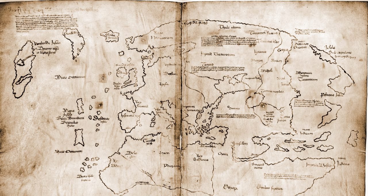
The Vinland Map, a world map drawn on parchment, first surfaced publicly in 1957, when it was offered to the British Museum, which declined to buy it. It was later purchased through the Yale benefactor Paul Mellon and published by Yale University Press in 1965.
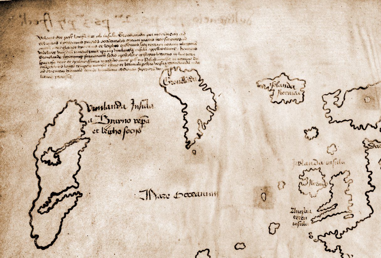
The map depicts the Atlantic Ocean with Iceland labeled 'Isolanda Ibernica,' Greenland labeled 'Gronelada,' and a large western landmass labeled 'Vinilanda Insula,' or Vinland Island, corresponding to northeastern North America. If it were genuine, it would be the earliest known European map to depict the Americas, predating Columbus by decades.
The map's parchment has been radiocarbon dated to about 1434 CE, give or take roughly a decade, by more than one independent laboratory. The skin it is drawn on is genuinely medieval. The trouble, as later work would show, is the ink.
02The ink that gave it away
If the parchment is real, the whole case turns on what was drawn onto it. And here the chemistry is unusually blunt.
| What was tested | Finding | Verdict |
|---|---|---|
| Parchment | Radiocarbon dated to about 1434 CE | Genuinely medieval |
| Ink (McCrone) | Contains anatase, a titanium dioxide not made before about 1920 | Modern |
| Ink (Raman) | Anatase matches synthetic titanium white, used since about 1923 | Modern |
| Yale, 2021 | Ink holds 20th-century synthetic components | Forgery |
McCrone Associates analyzed the map's ink and found anatase, a crystalline form of titanium dioxide, in a manufactured form that did not exist before roughly 1920. In plain terms, the lines of the map were drawn with 20th-century ink on genuinely old parchment.
Later, Raman spectroscopy analysis independently confirmed the anatase particles in the ink, matching the modern synthetic titanium white pigment that has been used in paints and inks only since roughly 1923.
One counter-argument held that trace amounts of anatase can occur naturally in some old inks. But the quantity found in the Vinland Map's lines, and the crystal shape of it, match a modern manufactured pigment far better than a stray natural impurity.
In 2021, Raymond Clemens of Yale's Beinecke Rare Book and Manuscript Library announced that extensive new spectroscopic analysis had confirmed the ink contains synthetic 20th-century components. Yale officially declared the Vinland Map a modern forgery drawn on authentically old parchment.
03The Zeno Map: a Renaissance family's tall tale
The second map is stranger, because nobody is quite sure how much of it was ever meant to be taken as true.
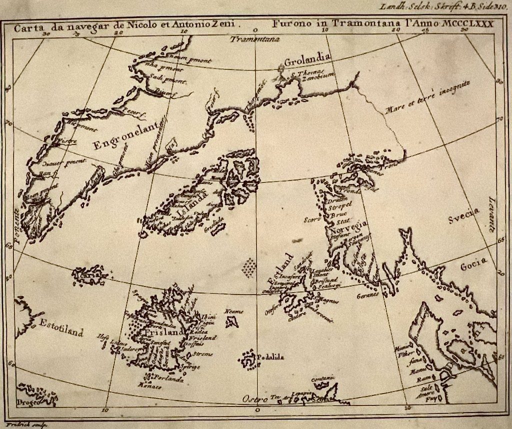
The Zeno Map, or Carta da Navegar, was published in Venice in 1558 by Nicolò Zeno the Younger, who claimed it was based on letters written by his ancestors Nicolò Zeno and Antonio Zeno in the 1380s and 1390s, describing voyages to the Faroe Islands, Iceland, Greenland, and possibly North America.
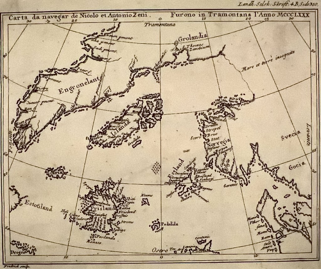
The map shows a recognizable but seriously distorted Greenland, complete with some interior detail, alongside Iceland and several mysterious islands, including one called 'Frislanda,' which may be a garbled rendering of the Faroe Islands or an outright invention.
Kirsten Seaver, in 'Maps, Myths, and Men' (2004), concluded that the Zeno narrative mixes genuine Norse geographical knowledge, already available from other sources by the 16th century, with fabrications by Nicolò the Younger meant to burnish his family's prestige.
Some researchers note that a few fjord placements on the map's Greenland line up with real geography. That can sound uncanny, but it more likely reflects Norse knowledge passed down through other 16th-century sources than any direct 14th-century observation by the Zeno brothers themselves. This particular point rests on general impression rather than a single firm citation, so we hold it loosely.
Erik Wahlgren, in 'The Vikings and America' (1986), argued that the Zeno narrative is largely a 16th-century fabrication assembled from available Norse saga material, and that the map's Greenland derives from existing charts such as the Claudius Clavus map of 1427.
04The Buache Map: Antarctica before the ice?
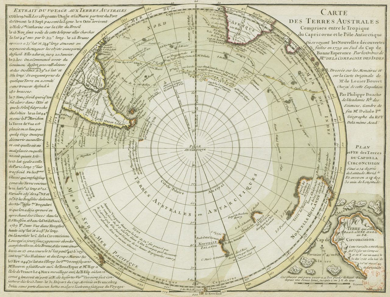
The third map is the one the ancient-mysteries world loves most, because at a glance it seems to show a continent that would not be properly discovered for almost a century after it was drawn.
Philippe Buache (1700 to 1773), Royal Geographer of France, published a map in 1737 titled 'Carte des Terres Australes,' showing a southern landmass in roughly the position of Antarctica, split into two separate masses by what looks like a waterway.
An alternative reading, advanced by Charles Hapgood and later by Hancock, holds that this two-part division resembles the true shape of Antarctica beneath its ice, where West and East Antarctica are separated by a deep sub-ice trough revealed only by modern radar surveys. On that reading, the map implies access to knowledge of Antarctica's sub-ice geography that was not otherwise mapped until the International Geophysical Year of 1957 to 1958.
The mainstream reading is far more ordinary. 18th-century geographers routinely hypothesized about a 'Terra Australis Incognita,' an unknown southern land, and Buache was doing exactly that. Overlaid on a modern map, his outline does not closely match the actual coastlines of Antarctica.
The strong claim, that the Buache Map proves ancient knowledge of Antarctica's shape under the ice, does not hold up. A careful comparison shows the landmass does not closely match the real continent, sub-ice or otherwise, and it is far better explained as speculative 18th-century cartography in the ordinary Terra Australis tradition.
05One theory to bind them, and why it slips
There is a single idea that tries to pull all three maps, and a few others, into one grand story.
Charles Hapgood's 'Maps of the Ancient Sea Kings' (1966) proposes that controversial maps, including the Buache Map, the Piri Reis Map, and the Oronteus Finaeus Map, descend from lost ancient source maps made by a pre-Ice Age maritime civilization that had charted the world's coastlines, Antarctica included, before it froze over. The idea requires three unproven things to all be true: that such a civilization existed before roughly 10,000 BCE, that it produced accurate maps, and that those maps survived thousands of years of copying to reach medieval and Renaissance cartographers. None of the three has direct evidence.
This is why cartographic historians handle the three maps one at a time rather than citing them together as a set. The Vinland Map is a demonstrated 20th-century forgery on old parchment. The Zeno Map is treated by most historians as an unreliable 16th-century fabrication. The Buache Map is better explained as hypothetical Terra Australis cartography than as a record of anything actually observed. Stacked together they can feel like a pattern. Taken one by one, each simply dissolves.
Fast Facts
- Vinland Map
- 20th-century forgery on genuinely medieval parchment
- Vinland parchment
- Radiocarbon dated to about 1434 CE
- Vinland verdict
- Yale declared it a forgery in 2021
- Zeno Map
- Venice, 1558, by Nicolò Zeno the Younger
- Buache Map
- Paris, 1737, by Philippe Buache
- The fringe hypothesis
- Hapgood's lost pre-Ice Age sea kings (1966)
- How historians treat them
- Individually, not as collective proof
What we can actually stand behind
The Vinland Map forgery is settled. The parchment is genuinely medieval, the ink is 20th-century synthetic pigment, multiple independent labs reached the same finding across decades, and Yale closed the case with its 2021 declaration.
The Zeno Map is most credibly a 16th-century fabrication that borrowed real Norse geography (Seaver, Wahlgren), and the Buache Map is most credibly speculative Terra Australis cartography. Both readings rest on essentially one or two historians each, so we hold them firmly but without pretending they are airtight.
Hapgood's lost pre-Ice Age mapmaking civilization needs three separate unproven things to all be true at once, and not one of them has direct evidence.
The claim that the Buache Map proves ancient knowledge of Antarctica's shape beneath the ice does not survive a careful overlay. The outline does not match the real continent, sub-ice or otherwise, and ordinary 18th-century Terra Australis speculation explains it without any lost civilization.
Which is where the honest mystery actually lives. The Vinland Map is closed, the Buache Map is best read as an educated guess, and the Zeno Map is mostly a Renaissance invention. Yet even the invention was built on something real: genuine Norse geography, carried down through sources nobody has fully traced. How much older, authentic knowledge is folded inside a fabricated map, and who first wrote it down? On that, the parchment still is not talking.
Sources & further reading
Everything above is drawn from our research library on Theories of Anything. Open the full files to check the sourcing and go deeper.
Image credits
- The Vinland Map (full parchment) photograph by the Beinecke Rare Book & Manuscript Library, Yale University Press, via Wikimedia Commons. Public Domain (published in the US 1931-1977 without a copyright notice) Source.
- The Vinland Map (detail, Vinilanda Insula) photograph by Yale University Press, via Wikimedia Commons. Public Domain (CC0 / PD Mark 1.0, no known copyright restrictions) Source.
- Nicolò Zeno the Younger's 1558 Carta da Navegar photograph by Nicolò Zeno the Younger, via Wikimedia Commons. Public Domain / CC0 (published before 1931 in the US) Source.
- Philippe Buache's Carte des Terres Australes photograph by Philippe Buache, via Wikimedia Commons. Public Domain (PD Mark 1.0 / PD-Art, life+100 or fewer) Source.
- Card crop of The Vinland Map (full parchment) photograph by the Beinecke Rare Book & Manuscript Library, Yale University Press, via Wikimedia Commons. Public Domain (published in the US 1931-1977 without a copyright notice) Source.