Megaflood Country: Reading the Scars of Ancient Deluges
A river cannot cut a canyon through solid rock in an afternoon. It cannot pile gravel into ripples the size of houses, or strand a boulder far from any bedrock that could have produced it, or carve a strait deep enough to turn a peninsula into an island. Only a flood can do that, a flood on a scale the modern world has never once watched happen. And yet the scars are everywhere, once you learn to read them: in the mountains of Siberia, on the floor of the English Channel, along drowned coral reefs in the tropics, under the Black Sea, at the bottom of the Strait of Gibraltar, and even on the surface of Mars. This is not the story of one flood. It is a field guide to the fingerprints they all leave behind, and to five very different deluges, at five wildly different scales, that left them. Here is the file, every fact wearing its tier.
There is a temptation, with catastrophes this large, to tell each one as a single dramatic story with a hero and a villain. This file resists that, on purpose. What follows is closer to a field guide than a drama, because the real subject here is not any one flood. It is the signature a megaflood leaves in the rock, the same handful of fingerprints wherever and whenever one has passed, and the very different floods, at wildly different scales, that left them. Some of what follows is settled beyond argument. Some is a genuinely open scientific debate. A little of it is speculation that should be labeled and left as speculation. And two familiar claims are simply false. The fastest way to cheapen a real catastrophe is to blur those layers together, so we will read them tier by tier. Let us open the file.
01The Fingerprints A Flood Leaves Behind
Start with the method, because it is the thing that ties every case in this file together. Whenever a true megaflood has passed, on any continent and by any mechanism, it leaves the same recurring family of physical fingerprints, and geologists have learned to read them. Giant current ripples, gravel dunes built in the same shape as the little ripples on a streambed but scaled up to tens of meters high. Scoured bedrock channels, land stripped clean of its soil down to naked rock, the feature that gave the Channeled Scablands their name. Streamlined islands, teardrop-shaped remnants of tougher rock left standing while the water tore away everything around them. Transported erratic boulders, rock rafted far from any outcrop that could have produced it and dropped on high ground. Stacked slackwater rhythmites, neat repeated layers of fine sediment dropped in quiet side valleys, one graded bed for every pulse of a flood that came back again and again. And erosional channels cut at a scale no ordinary river could reach. Find that assemblage together and you are not looking at slow erosion. You are looking at the track of a flood.
The textbook example of that assemblage sits next door on this same wing, and this file will not retell it. The Missoula floods of the Pacific Northwest, fed by an ice-dammed lake that held roughly 2,500 cubic kilometers of water and failed catastrophically dozens of times over some 2,000 years, carved the Channeled Scablands of eastern Washington and left every fingerprint on the list: giant ripples at Camas Prairie, dry cataracts, stranded erratics, stacked flood beds. Their peak discharge, around 17 million cubic meters per second, is estimated at roughly ten times the combined flow of every river on Earth today. The full story, including the geologist who read it first and was called a crank for the better part of forty years, is its own file on this wing, The Missoula Floods. Here it is only the reference specimen. Every other flood in this file is measured against it.
| The Fingerprint | What It Looks Like | What It Means |
|---|---|---|
| Giant current ripples | Gravel dunes tens of meters high, best seen from the air | Water tens of meters deep moving at speed, never a river |
| Scoured bedrock channels | Land stripped to bare rock, dry canyons and coulees | Sheet flooding tore the soil off the bedrock |
| Streamlined islands | Teardrop-shaped high ground left standing in the flow | Tougher rock that the flood could not carry away |
| Transported erratics | Boulders stranded far from any outcrop that made them | Rock rafted by water, not carried by any river |
| Slackwater rhythmites | Repeated graded layers in quiet side valleys | One layer per flood pulse, a record of many floods |
| Oversized channels | Canyons and straits cut at a scale no river reaches | A single discharge far beyond ordinary flow |
02Siberia: The Largest Freshwater Flood We Know Of
Now the new material. In the Altai Mountains of southern Siberia, during the last deglaciation, glaciers dammed the Chuya and Kuray river basins and impounded an enormous ice-dammed lake, glacial Lake Kuray-Chuya. When that dam failed, it released a flood whose estimated peak discharge reaches roughly 18 million cubic meters per second or higher, in the same class as the Missoula floods and, by some estimates, beyond them. The corpus file frames the Altai flood as possibly the largest freshwater flood in Earth's history, and that hedge is worth keeping exactly as stated. Comparing the peak discharge of prehistoric floods carries wide uncertainty, so this is a strong possibility, not a settled ranking. What is solid is the raw scale: this was among the very biggest freshwater floods the planet has ever produced.
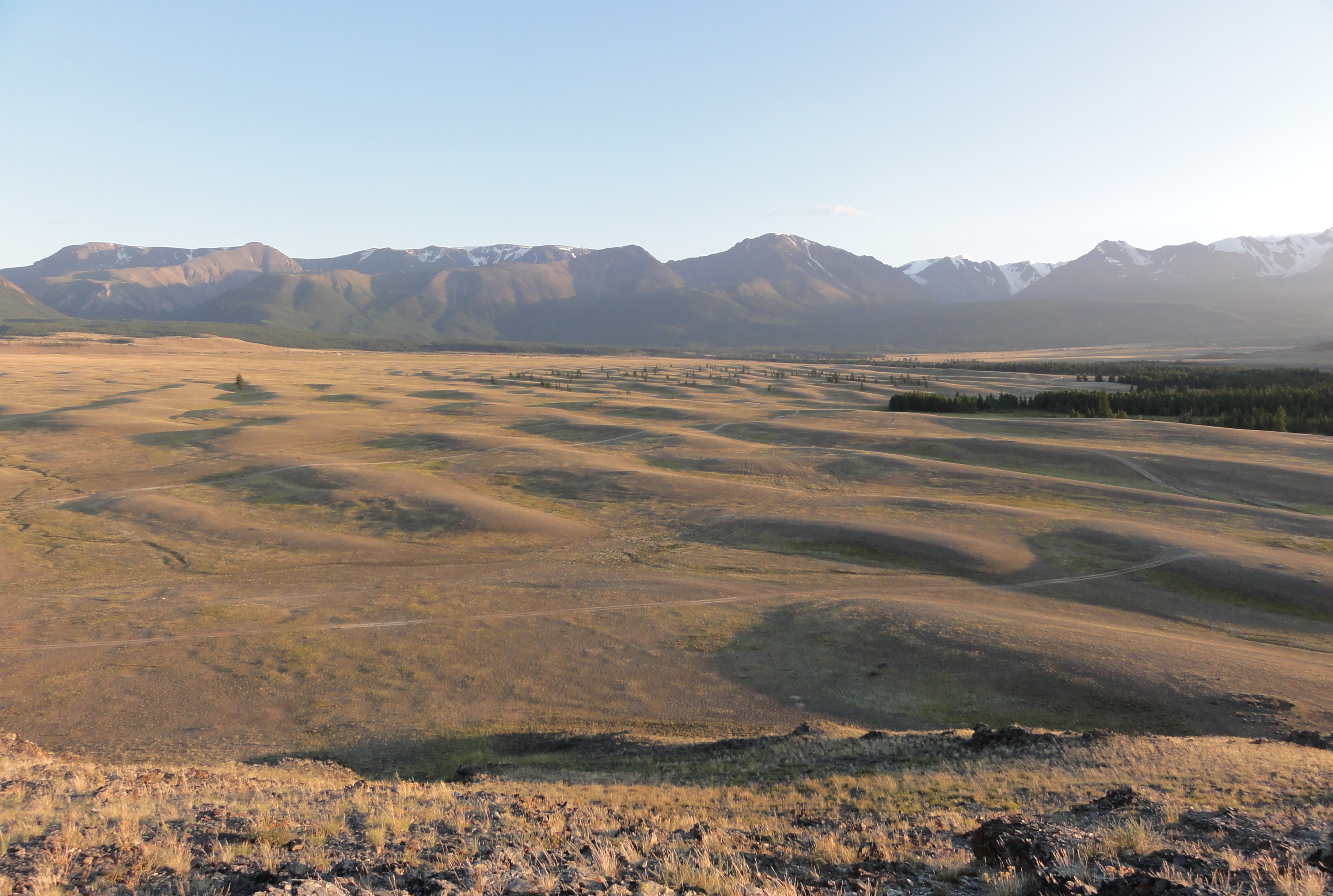
The evidence on the ground is the same family of fingerprints, sized to match. Across the Kuray and Chuya basins lie fields of giant gravel ripples, dunes up to about 20 meters high with roughly 200 meters between crests, spread across kilometer-scale fields. Run-up marks left by the flood sit more than 100 meters above the level of the present river, and gravel bar deposits stack tens of meters thick. These are the diagnostic megaflood signatures documented by Baker and colleagues in 1993 and by Herget in 2005, and they are exactly what you would expect from an ice-dammed lake emptying in a matter of days.
One specific, much-photographed ripple field, east of the Tyetyo River in the Chuya Basin, has been measured separately at up to 18 meters high with a 225 meter wavelength, deposited by a conjoined Chuya-Kuray paleolake that burst with a volume of roughly 600 cubic kilometers. Those figures differ slightly from the rounder corpus numbers, and it is worth saying why rather than smoothing it over: they are simply different measurements taken at different ripple fields across one vast flood system. That is normal variation, not a contradiction, and both sets of numbers describe the same enormous event.
One more thing about the Altai flood is worth noting, and worth handling with care. Unlike the Missoula floods, which drained through a thinly populated Pleistocene Pacific Northwest, the Altai flood happened in central Asia, far closer to the cradle of the world's oldest flood mythologies in Mesopotamia, India, and China. The corpus file raises that geographic proximity deliberately. It is a suggestive fact, not a demonstrated link. Nobody has shown that any specific flood myth records the Altai event, and geography alone cannot prove influence. Read it as an open question hanging over the map, not as an answer written on it.
03The Channel: How Britain Became An Island
For most of the last several hundred thousand years, Britain was not an island. During glacial periods, when so much water was locked into ice that global sea level stood more than 120 meters below where it is today, a ridge of chalk ran across what is now the Strait of Dover, a dry land bridge joining England to France. You could have walked from Kent to Calais. Twice, a catastrophic flood put an end to that.
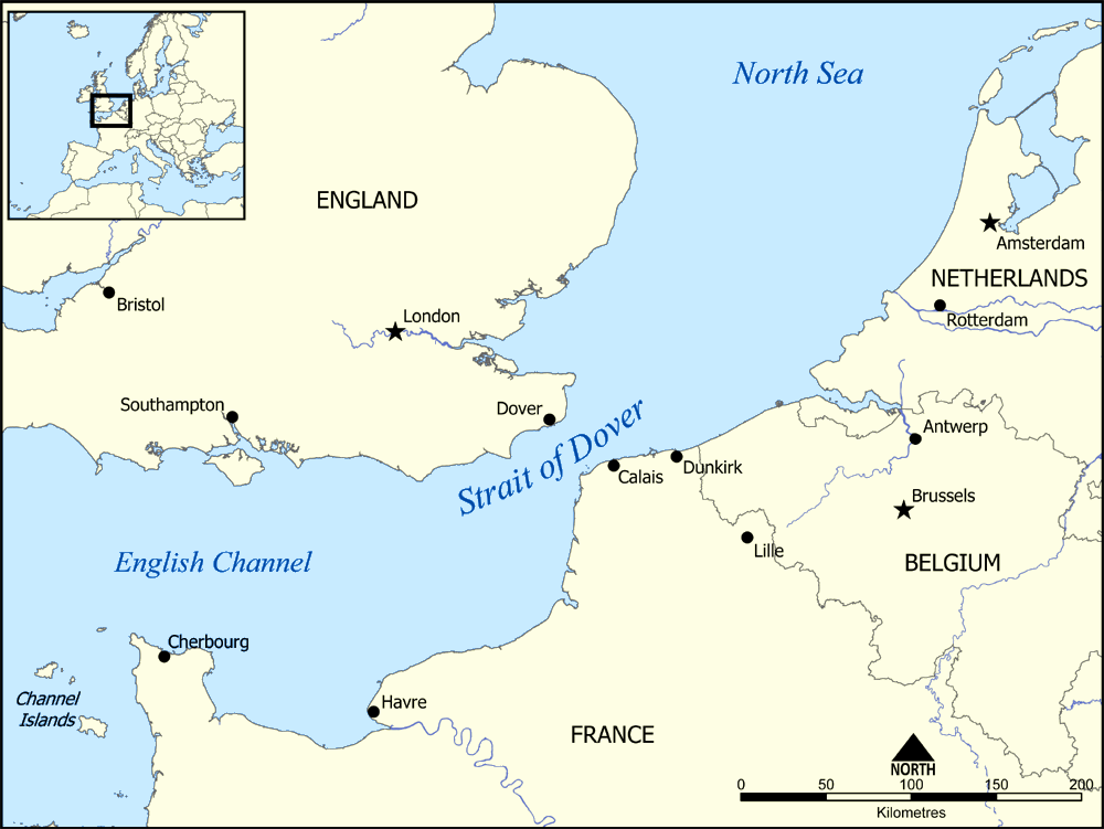
The first flood came roughly 450,000 years ago, during the glacial stage geologists label Marine Isotope Stage 12. A vast proglacial lake had ponded in the North Sea basin, fed by meltwater and held back on its southern edge by that same chalk ridge between Dover and Calais. When the dam failed, the released water tore southward through the barrier and began carving the Dover Strait. A second catastrophic flood, roughly 200,000 years ago during Marine Isotope Stage 6, widened and deepened the Channel further. Two separate megafloods, not one, did the work.
The evidence sits on the floor of the English Channel, and it was mapped in detail by Gupta and colleagues in a 2007 paper in Nature using high-resolution sonar. They found a landscape of catastrophic flow drowned beneath the sea: submarine valleys carved straight into the Channel bedrock, streamlined islands of more resistant rock left standing within the flood path, giant flood-scoured grooves, and amphitheater-headed valleys, a shape that forms under catastrophic discharge rather than the slow work of a river. It is the Channeled Scablands assemblage again, only this time underwater.
The consequence was permanent, and it is the reason this flood matters far beyond geology. The strait the two floods carved was cut too deep to ever reconnect. When the ice melted and sea level rose again at the end of the last glaciation, the water flooded straight through the breach, and the chalk land bridge never came back. Britain was severed from continental Europe for good. A great deal of what followed, the island's separate development and its whole relationship to the continent, rests on a strait that two megafloods dug out of the rock.
04The Day The Ocean Rose Twenty Meters
Not every megaflood carves rock. Some raise the sea. Around 14,650 years ago, as the last Ice Age broke, the planet's oceans rose in a sudden lurch that geologists call Meltwater Pulse 1A. Global sea level climbed roughly 20 meters in 500 years or less, a rate above 40 millimeters a year. For scale, present-day sea-level rise runs about 3.6 millimeters a year, more than ten times slower. The water came from a massive ice-sheet collapse, most likely Antarctic and possibly Laurentide as well, and the physical record of its speed is written in coral. Reef cores from Barbados and Tahiti show reefs that were abruptly drowned at exactly this period, unable to grow upward fast enough to keep pace with the rising water.
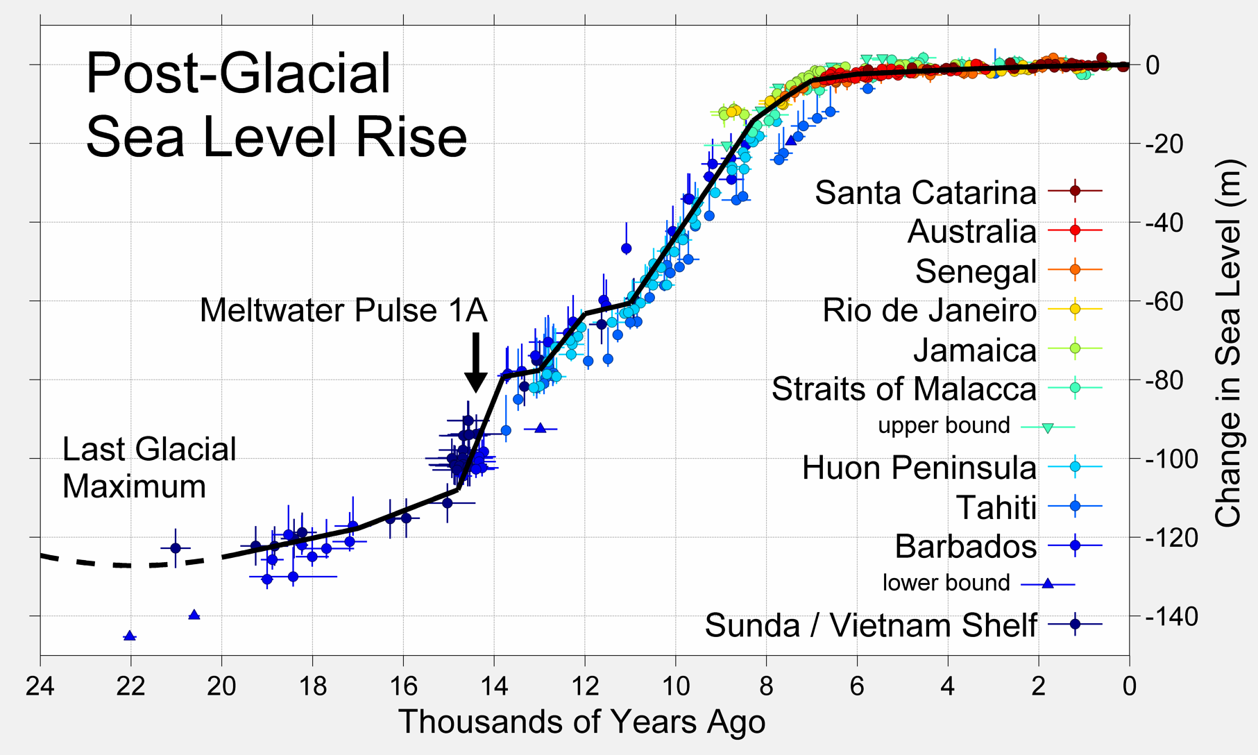
That much is Tier 1. What sits a rung or two lower is what it might have meant to anyone who was there. A 20 meter rise pushed coastlines inland worldwide, and any low-lying settlement of the time would have been steadily swallowed. The corpus file raises the idea that the memory of such an event could underlie some of the world's global flood traditions, and it is careful to frame that as a connection rather than a proven claim. It is a reasonable thought and an unprovable one. Mark it speculative and keep going.
05The Black Sea: The Flood We Still Argue About
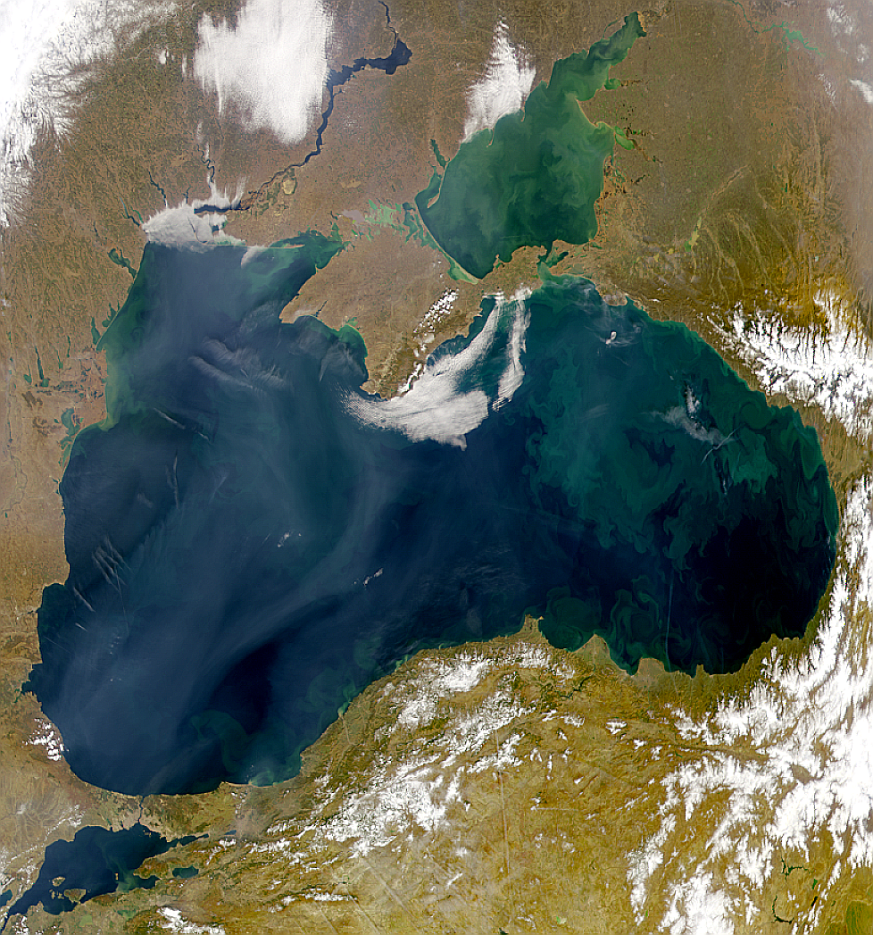
The next flood is the one scientists have not stopped arguing about, which is exactly why it is Tier 2 rather than Tier 1. In 1998 the marine geologists Ryan and Pitman proposed that around 5600 BCE the Mediterranean Sea breached the Bosporus strait and poured into the basin beyond it, where a smaller freshwater lake, the pre-flood Black Sea, then sat roughly 150 meters below its current level.
Their proposed mechanism was catastrophic. As post-glacial seas rose, the Mediterranean is thought to have overtopped the Bosporus sill and cut rapidly down through it, so that on the order of 200 times the volume of Niagara Falls poured through the breach for months on end. In their reconstruction the Black Sea shoreline retreated one to two kilometers a day, roughly 155,000 square kilometers of prime lakeside farmland went under, and the people living around that shrinking lake were driven outward in every direction.
That displacement is where the hypothesis gets its cultural charge. Ryan and Pitman suggested the refugees carried the memory of the flood with them: south into Mesopotamia, where it could have fed the flood of Gilgamesh and later Genesis, around the Black Sea coast, where it might underlie the Greek story of Deucalion, and outward beyond. This part is explicitly a hypothesis in the literature, not an established finding, and it should be read that way, as a plausible pathway rather than a proven one.
There is real supporting evidence. Sonar surveys have confirmed submerged ancient shorelines beneath the modern Black Sea. In 2000 the ocean explorer Robert Ballard located preserved structures more than 100 meters below the present surface that were interpreted as an ancient settlement drowned by the rising water. And archaeological evidence does point to a rapid dispersal of populations away from the Black Sea region around 5600 BCE. None of this is nothing.
But the hypothesis has serious, named critics, and they have not been answered away. Yanko-Hombach and colleagues argue that the pre-flood Black Sea did not stand as low as Ryan and Pitman claimed, and that some of the evidence points to a more gradual rise rather than a single catastrophic breach. The 5600 BCE date is itself imprecise and may shift. The honest status, and the corpus file states it plainly, is partial confirmation: a flooding of the Black Sea genuinely happened, but whether it was a sudden catastrophe or a slower transgression remains an open, actively contested question. This is not settled science dressed up as debate. It is a real one.
06The Mediterranean Refilled In Two Years
The largest flood in this file happened before there was anyone on Earth to drown. Between roughly six and five million years ago, tectonic movement closed the Strait of Gibraltar and cut the Mediterranean off from the Atlantic. Sealed away in that arid climate, the sea did something almost unimaginable: it very nearly dried up. Over the Messinian Salinity Crisis the Mediterranean shrank to a scatter of disconnected hypersaline lakes on the floor of a desert basin more than a kilometer below the level of the world ocean. Then, about 5.33 million years ago, the barrier at Gibraltar gave way. In a 2009 paper in Nature, Garcia-Castellanos and colleagues modeled what happened next: the Atlantic broke back in and refilled the entire Mediterranean basin in a period of months to at most about two years.
The numbers are the largest in the file. The Zanclean flood's estimated peak discharge reaches up to 100 million cubic meters per second, on the order of a thousand times the flow of the Amazon River, and the water in the Mediterranean basin may have risen as fast as 10 meters a day. The physical evidence is a huge erosional channel gouged into the rock at the base of the Strait of Gibraltar, still detectable in submarine topography, along with thick Messinian evaporite deposits, salt layers, buried in the deep Mediterranean that record the near-total drying that came first.
By the sheer volume of water it moved, the Zanclean flood is the largest flood event known anywhere on Earth. That superlative needs one careful footnote, because ranking floods depends on which metric you choose. The Altai and Missoula floods compete for the title of largest freshwater flood by peak discharge, while the Zanclean, refilling an entire sea, wins on total volume of water involved. There is no contradiction between those two claims; they measure different things. No human being witnessed the Zanclean flood. It happened roughly three million years before our genus existed. It stands in this file as proof of the raw ceiling of what catastrophic flooding can reach on this planet.
| The Flood | When | The Scale | The Signature |
|---|---|---|---|
| Altai (Siberia) | End of the last Ice Age | Discharge ~18 million cubic m/s, possibly the largest freshwater flood known | Giant gravel ripples up to 20 m high |
| English Channel | ~450,000 and ~200,000 years ago | Two megafloods that carved the Dover Strait | Submarine valleys and streamlined islands on sonar |
| Meltwater Pulse 1A | ~14,650 years ago | ~20 m of global sea-level rise in under 500 years | Abruptly drowned coral reefs at Barbados and Tahiti |
| Black Sea (contested) | ~5600 BCE | A proposed Bosporus breach, ~200x Niagara Falls | Submerged shorelines, magnitude still debated |
| Zanclean (Mediterranean) | ~5.33 million years ago | Up to 100 million cubic m/s, largest known flood by volume | An erosional channel at the base of Gibraltar |
| Missoula (cross-reference) | End of the last Ice Age | ~17 million cubic m/s, ~10x every river on Earth | The Channeled Scablands, see the sibling file |
07Why We Denied All Of This For A Century
Here is the strange part. Almost every flood in this file was resisted, ignored, or ridiculed by mainstream geology when it was first proposed, and the reason is a paradigm war that ran through the whole science. In the 1830s Charles Lyell formalized uniformitarianism, the principle that the Earth is shaped only by the same slow, gradual processes we can watch working today, summed up in the phrase the present is the key to the past. It was defined against catastrophism, associated with Georges Cuvier earlier in the century, which held that Earth's history includes sudden violent events unlike anything in ordinary modern experience. Uniformitarianism won, institutionally and decisively, by the middle of the 19th century, and for more than a hundred years afterward invoking a catastrophe to explain a landscape marked you as unscientific.
The pendulum swung back through a specific sequence of shocks. Bretz's megaflood was vindicated in the 1960s, after the establishment had rejected it for some forty years. Impact cratering was recognized as a genuine geological process in the following decades. And in 1980 an asteroid impact was proposed as the cause of the mass extinction that ended the age of the dinosaurs, with the Chicxulub crater itself pinpointed as the site a decade later. Modern geology now accepts both registers at once. The current consensus, sometimes called neocatastrophism, holds that catastrophes are real, important, and leave distinctive signatures, but that they operate within a broadly gradualist framework. The either-or is gone. The corpus file draws one pointed lesson from this history and connects it to another file on this very wing: the same institutional reflex that rejected Bretz for forty years may still be shaping how a contested modern catastrophist claim, the Younger Dryas impact hypothesis, gets received today. Being ridiculed by the establishment does not make an idea right. But the history is a standing warning against assuming that it makes an idea wrong.
08The Same Scars On Another Planet
The method that reads these floods turned out to work off Earth entirely. In 1978, in a paper in the journal Science titled The Spokane Flood Controversy and the Martian Outflow Channels, the geologist Victor Baker argued that the Channeled Scablands, the terrestrial type-example of catastrophic flooding, are the interpretive key to a set of enormous channels on Mars. On his reading, those Martian channels were carved by catastrophic floods on an early Mars that once had liquid water moving in violent volume. The deeper story of how a once-ridiculed flood became a tool for reading another planet belongs to the Missoula file next door. What matters here is the principle it establishes: the fingerprints are not unique to Earth.
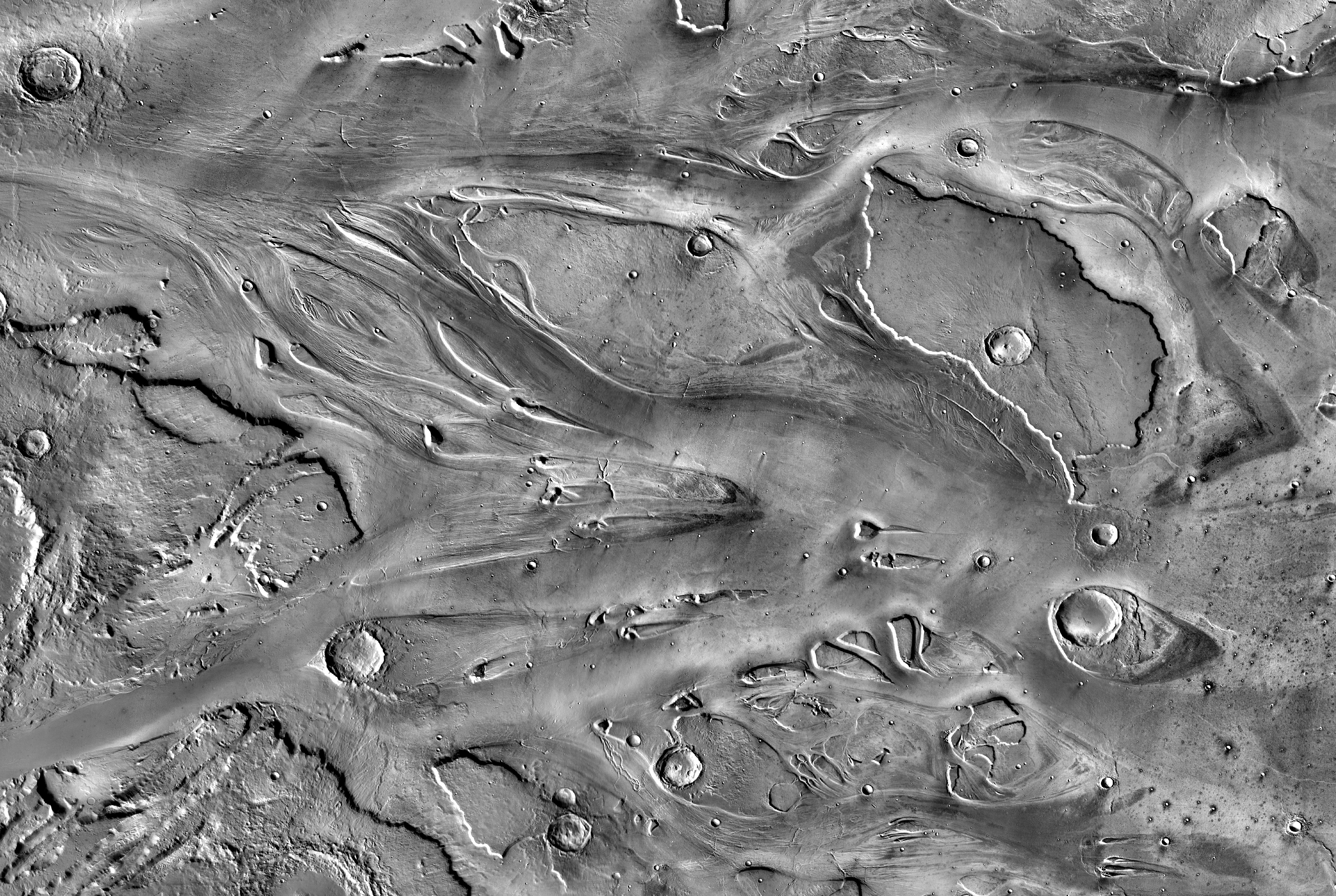
Look at Kasei Valles, one of the largest outflow channel systems on Mars. According to NASA's Jet Propulsion Laboratory, it runs up to 482 kilometers wide and 1,580 kilometers long, dimensions that dwarf the Grand Canyon, which the same source notes is only 29 kilometers at its widest and 446 kilometers long. It flows eastward through Lunae Planum and empties into the Chryse Planitia lowlands. And in the orbital infrared imagery, the floor of Kasei Valles is dotted with tadpole-shaped streamlined remnants, crater rims left standing with long tails pointing downstream, the same islands-in-a-flood morphology mapped on the floor of the English Channel, here cut into the surface of Mars and read, on Baker's framework from the previous section, as the work of the same class of catastrophic flow this file has been tracking all along.
09What The Floods Might Still Be Telling Us
Now the softer ground, clearly labeled as such. More than 500 flood traditions have been documented around the world. They cannot all record a single event, because no single event touched all those places, but the composite memory hypothesis proposes that collectively they may encode several real catastrophic water events spread across more than ten thousand years: Meltwater Pulse 1A, the onset of the Younger Dryas, the Black Sea flood, remembered tsunamis, and regional megafloods including Altai, Missoula, and the Yellow River. The suggestive part is that different traditions carry different specific details that seem to fit different events. Might the flood of Noah and Gilgamesh trace to the Black Sea or the Persian Gulf? Might the Hindu story of Manu recall an Indian Ocean event? Might Aboriginal Australian traditions preserve Meltwater Pulse 1A? These are pattern-matching hypotheses, and not one of the specific pairings is established. They are offered here as exactly that: interesting, unproven, and squarely Tier 3.
There is a related and genuinely unsettling implication, and it splits cleanly into a fact and an inference. The fact is Tier 1: at the height of the last Ice Age, around 26,500 years ago, sea level stood more than 120 meters lower than today, which means millions of square kilometers of continental shelf, often the flattest, best-watered, mildest land around, are now permanently underwater. The inference is the open part. If any human communities lived on that shelf before roughly 10,000 years ago, their remains would now lie offshore and largely unsurveyed. Documented shallow-water sites like Yonaguni, Dwarka, Pavlopetri, and the artifacts of Doggerland show that submerged human traces are real and findable, but the deeper shelves have barely been looked at. Our picture of where people lived before the sea rose is limited, honestly, to what happens to sit above today's waterline. What lies below is an open question, not a discovery.
10What This Is Not
Because this is a file that takes real catastrophic floods seriously, it has to be just as clear about the two claims that always get bolted onto them and that the evidence flatly rejects.
No, none of this is evidence for a single global flood that once covered the whole Earth, and the reason is not theology, it is arithmetic. There is not enough water on or in the planet to do it. Mount Everest stands 8,849 meters high. To cover it would take on the order of 4.5 billion cubic kilometers of water beyond everything already in the oceans, ice caps, atmosphere, and crust, and that water simply does not exist anywhere on Earth. The attempts to rescue a literal worldwide flood from this problem, the vapor-canopy theory and the hydroplate theory, are not supported by any geological or physical evidence. Every real flood in this file is the opposite of a global one: each is regional, each has a specific mechanism, and each left specific, local scars. That is precisely what makes them real.
And no, Noah's Ark has not been found on Mount Ararat. Claims to have found it have circulated since the 1800s, and almost all of them turn out to identify ordinary rock formations. The so-called Ararat anomaly, a shape visible in satellite imagery at about 4,700 meters, has been investigated and shows no confirmed artificial structure. The Durupinar site, publicized since 1959 and still promoted today, is a naturally occurring geological feature in the rough shape of a boat hull, not a vessel. A real drowned landscape under the Black Sea or the North Sea is a far more interesting thing than a wooden ship on a mountain that was never there.
11Every Claim, Every Tier
Here is the whole file on one page, each claim wearing its tier, because the surest way to ruin a subject like this one is to let rock-solid geology, a live scholarly debate, a set of labeled guesses, and two flat falsehoods all blur into one undifferentiated legend. They are not the same, and the tiers are what keep them apart.
| The Claim | Tier | The Basis |
|---|---|---|
| Megafloods leave the same diagnostic family of scars worldwide | Tier 1 | Synthesis of the corpus case studies |
| The Altai flood reached a peak discharge around 18 million cubic m/s | Tier 1 | Baker et al. 1993; Herget 2005 |
| Two megafloods carved the English Channel and made Britain an island | Tier 1 | Gupta et al. 2007, Nature |
| Meltwater Pulse 1A raised sea level ~20 m in under 500 years | Tier 1 | Barbados and Tahiti coral records |
| Sea level stood over 120 m lower at the last glacial maximum | Tier 1 | The post-glacial sea-level record |
| The Black Sea was flooded through the Bosporus around 5600 BCE | Tier 2 | Ryan and Pitman 1998; magnitude still debated |
| The Zanclean flood refilled the Mediterranean in months to two years | Tier 2 | Garcia-Castellanos et al. 2009, Nature |
| Catastrophist floods were denied for a century, then restored | Tier 2 | Lyell vs Cuvier; Bretz; Chicxulub 1980 |
| The Scablands are the key to reading Mars's outflow channels | Tier 2 | Baker 1978, Science |
| The 500-plus flood myths may encode several real water catastrophes | Tier 3 | Pattern-matching, no pairing established |
| Coastal communities may lie undiscovered on the drowned shelf | Tier 3 | Sea-level physics real, the inference open |
| A single flood once covered the whole Earth | Tier 4 | Physics forbids it; no such water exists |
| Noah's Ark has been found on Mount Ararat | Tier 4 | No confirmed discovery; natural formations |
Fast Facts
- The Method
- Read the scars: giant ripples, scoured bedrock, streamlined islands, erratics, rhythmites, oversized channels
- The Biggest Freshwater
- The Altai flood in Siberia, discharge ~18 million cubic m/s, possibly the largest freshwater flood known
- The Island-Maker
- Two English Channel megafloods carved the Dover Strait and cut Britain from Europe for good
- The Ocean Pulse
- Meltwater Pulse 1A, ~20 m of sea-level rise in under 500 years, about 14,650 years ago
- The Argued-Over One
- The Black Sea Bosporus breach, ~5600 BCE, a real flooding whose catastrophic magnitude is contested
- The Largest Known
- The Zanclean flood refilled the Mediterranean in months to two years, ~5.33 million years ago, on a single influential model
- The Paradigm
- Catastrophism denied for a century, then restored through Bretz, Chicxulub, and neocatastrophism
- On Another Planet
- Mars's outflow channels such as Kasei Valles, read through Earth's own flood scars (Baker 1978)
- What It Is Not
- Not a single literal global flood, which physics forbids, and no Ark has been found on Ararat
- The Verdict
- The floods are real and readable; some myth links stay speculative; the global flood is false
What We Can Actually Stand Behind
The floods are real, and so are their scars. A megaflood leaves a recurring signature, giant ripples, scoured bedrock, streamlined islands, stranded erratics, stacked rhythmites, oversized channels, and reading that signature is settled method. So are the cases built on hard physical evidence: the Altai flood in Siberia, with a peak discharge around 18 million cubic meters per second and ripple fields up to 20 meters high; the two English Channel megafloods that carved the Dover Strait and permanently cut Britain from Europe, mapped by sonar in Gupta and colleagues' 2007 Nature study; and Meltwater Pulse 1A, roughly 20 meters of global sea-level rise in under 500 years, recorded in drowned coral at Barbados and Tahiti. That sea level stood more than 120 meters lower at the last glacial maximum is likewise Tier 1, and Kasei Valles on Mars really is up to 482 kilometers wide, per NASA. All Tier 1.
Several of the biggest claims are credible but not closed. The Black Sea was genuinely flooded around 5600 BCE, but whether it was Ryan and Pitman's sudden Bosporus catastrophe or Yanko-Hombach's slower transgression is an actively contested question. The Zanclean flood, which refilled the Mediterranean in months to two years about 5.33 million years ago and ranks as the largest known flood by total volume, rests largely on a single influential 2009 Nature model. The century-long suppression of catastrophist explanations, and its neocatastrophist resolution, is well-founded history of science. And Victor Baker's use of the Channeled Scablands to read the outflow channels of Mars is established planetary science, from his 1978 paper in Science.
Some links are guesses, and stay labeled as guesses. That the world's 500-plus flood traditions collectively encode several real water catastrophes is a pattern-matching hypothesis, and no specific pairing, Noah to the Black Sea, Manu to the Indian Ocean, an Aboriginal tradition to Meltwater Pulse 1A, is established. That the memory of Meltwater Pulse 1A underlies any particular flood myth is likewise unproven. And while the drowned continental shelf is real Tier 1 physics, the idea that undiscovered coastal communities lie waiting on it is an open inference, not a find.
And two familiar claims are simply false, so say it flatly. No, none of these floods is evidence for a single global flood that once covered the Earth: the planet does not contain enough water to cover its own mountains, short by billions of cubic kilometers, and the vapor-canopy and hydroplate theories invented to get around that are unsupported. And no, Noah's Ark has not been found on Mount Ararat; the Ararat anomaly and the Durupinar site are natural formations, not a ship. Every real flood in this file is regional, mechanistic, and specific, which is exactly what a global deluge is not.
So hold the layers apart and the subject grows larger, not smaller. There was no single Flood. There were many floods, at scales that run from a drowned mountain valley to an entire refilled sea, and they left the same handful of fingerprints wherever they passed, on this planet and on at least one other. We have learned to read those scars well enough to date a flood that finished before our species existed, and to recognize its twin on Mars. And yet the largest blank on the map is the one closest to home: the drowned shelves where people may have lived before the sea came up, still almost entirely unread. We know how to read the scars now. The open question is how much of our own lost world we are willing to go down and look for.
Sources & further reading
Everything above is drawn from our research library on Theories of Anything, which is where we worked from. The papers, reports and primary records listed beneath them are where you can check us independently.
Image credits
- Giant Current Ripples, Chuya Basin, Altai Republic photograph by Gaianauta via Wikimedia Commons. CC BY-SA 4.0 Source.
- Map of the Strait of Dover map by NormanEinstein via Wikimedia Commons. CC BY-SA 3.0 Source.
- Post-Glacial Sea Level Curve chart by Robert A. Rohde / Global Warming Art via Wikimedia Commons. CC BY-SA 3.0 Source.
- 1999 Satellite Photograph of the Black Sea photograph by NASA via Wikimedia Commons. Public Domain Source.
- Kasei Valles, THEMIS Infrared Mosaic, Mars image by NASA / JPL-Caltech / Arizona State University via Wikimedia Commons. Public Domain Source.
- Card crop of Giant Current Ripples, Chuya Basin, Altai Republic photograph by Gaianauta via Wikimedia Commons. CC BY-SA 4.0 Source.
.JPG)


