The Piri Reis Map: Antarctica Before Antarctica?
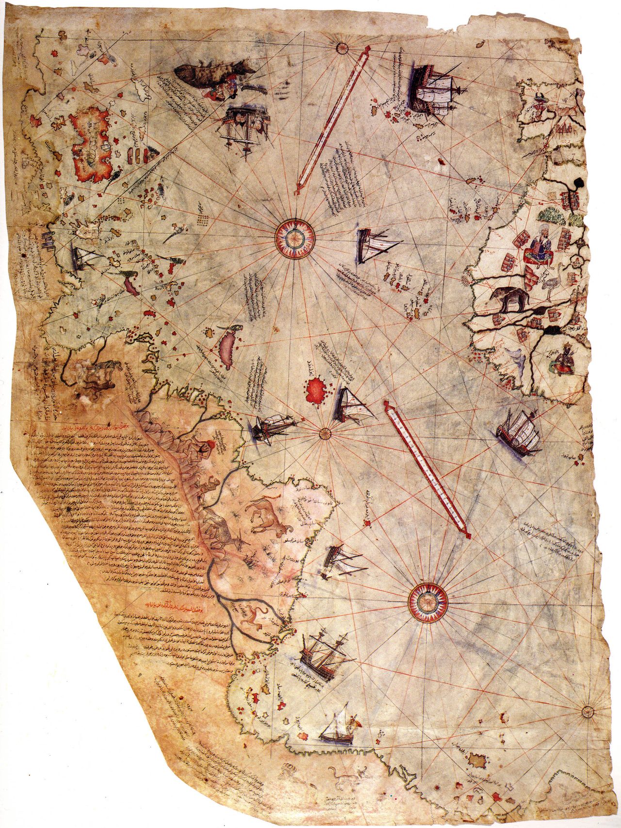
In 1929 a scrap of gazelle skin surfaced in an Istanbul palace. By 1966 it was being sold as a map of Antarctica, drawn ice-free, three centuries before anyone officially saw the place. Here is the file, opened from the parchment up, every claim wearing its evidence.
In 1929, a curator sorting the old library of the Topkapi Palace in Istanbul unfolded a piece of gazelle skin and found a corner of the world. Half a world map, drawn in 1513 by an Ottoman admiral, the Atlantic down the middle, Europe and Africa on one edge, the coast of the Americas on the other. It should have been a proud footnote in the history of cartography. Instead, forty years later, it became the most famous “impossible map” on Earth, because someone decided its ragged southern coastline was Antarctica, mapped with no ice on it, three centuries before anyone officially laid eyes on the place. Let’s open the file.
01The man and the gazelle skin
This map is not anonymous, and it is not undated. Its own inked inscriptions name the maker and the year, which is exactly why it is such a good test case. We know precisely who drew it and when.
The surviving fragment is the western third of a world map drawn in 1513 CE on gazelle parchment by Piri Reis (Ahmed Muhiddin Piri, c. 1465 to 1553), an Ottoman admiral, navigator and cartographer who went on to write the Kitab-i Bahriye, a full navigational manual of the Mediterranean, in 1521. The fragment is held today in the Topkapi Palace Museum, Istanbul, inventory number H. 1824. None of that is in dispute.
Piri Reis did not claim to have surveyed the Atlantic himself. In his own notes on the map he wrote that he compiled it from roughly 20 older source charts, among them maps captured from a Spanish sailor who had sailed with Columbus. Several of Columbus’s original charts are genuinely lost, and Ottoman capture of Spanish navigational material is historically documented, so this claim is taken seriously by scholars.
| Region shown | How it reads |
|---|---|
| Iberia and the North African coast | Reasonably accurate for 1513 |
| The Caribbean (Cuba, Hispaniola) | Consistent with post-Columbian knowledge |
| Eastern South America, Brazil south | Recognizable coast, but distorted |
| The southern landmass | The disputed piece, bent to the east |
02What it gets right, and what it gets wrong
The map is a real achievement. It renders the Iberian Peninsula and the North African coast well for its period, shows the Caribbean islands in a way only a post-Columbian source could, and traces the eastern coast of South America from the Brazilian bulge and the Amazon delta southward. It is one of the earliest surviving maps to show the Americas at all, though not the very earliest (Juan de la Cosa’s map of 1500 beat it).
It is also full of ordinary errors. The Amazon River appears to be drawn twice. The scale changes between one section and the next. The proportions of South America are badly stretched. These are not the fingerprints of a single hyper-accurate master chart. They are exactly what you get when someone stitches 20 maps of different scales onto one sheet.
03Enter Hapgood
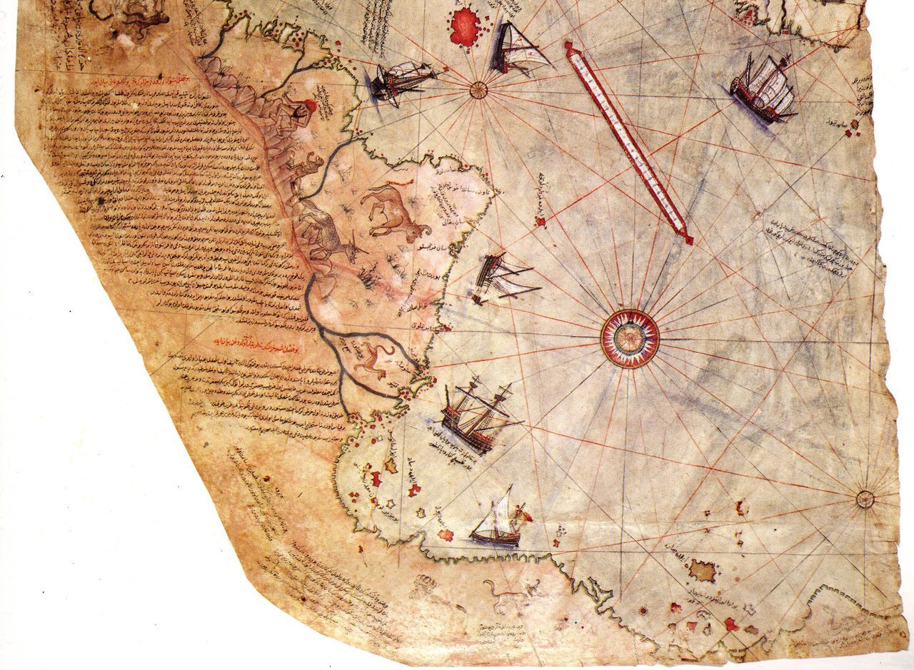
The map sat quietly famous until 1966, when Charles Hapgood published Maps of the Ancient Sea Kings. Hapgood argued that the southern landmass on the Piri Reis map, and on a handful of other early charts like the Oronteus Finaeus map of 1531 and the Buache map of 1737, was the coastline of Antarctica, drawn free of ice. His conclusion was enormous: the source charts must descend from a lost Ice Age civilization that had mapped the globe thousands of years before 1513. Graham Hancock later carried the idea to a mass audience in Fingerprints of the Gods in 1995.
Hapgood’s broad thesis, that some forgotten seafaring people surveyed the world in deep antiquity and passed their charts down through unknown hands, is creative and cannot be strictly disproven in the abstract. But it rests on zero physical evidence: no “ancient source map” has ever been found, and the entire chain of transmission is conjecture.
The Einstein detail is real but routinely oversold. Albert Einstein did write a warm foreword to Hapgood’s earlier book, Earth’s Shifting Crust (1958), expressing interest in crustal displacement. He did not endorse the ancient-map claims, which came later. A foreword about geology is not a physicist signing off on ice-free Antarctic cartography.
04Why the south coast is not Antarctica
Detailed cartographic analysis (McIntosh, The Piri Reis Map of 1513, 2000; Soucek, 2013) reads that southern coast far more simply: it is the South American coast continuing past Patagonia, rotated roughly 90 degrees to the east. Early portolan charts had no spherical projection, so when a cartographer ran out of parchment he bent the coastline to fit the space. That bend is a known drawing habit, not a lost continent.
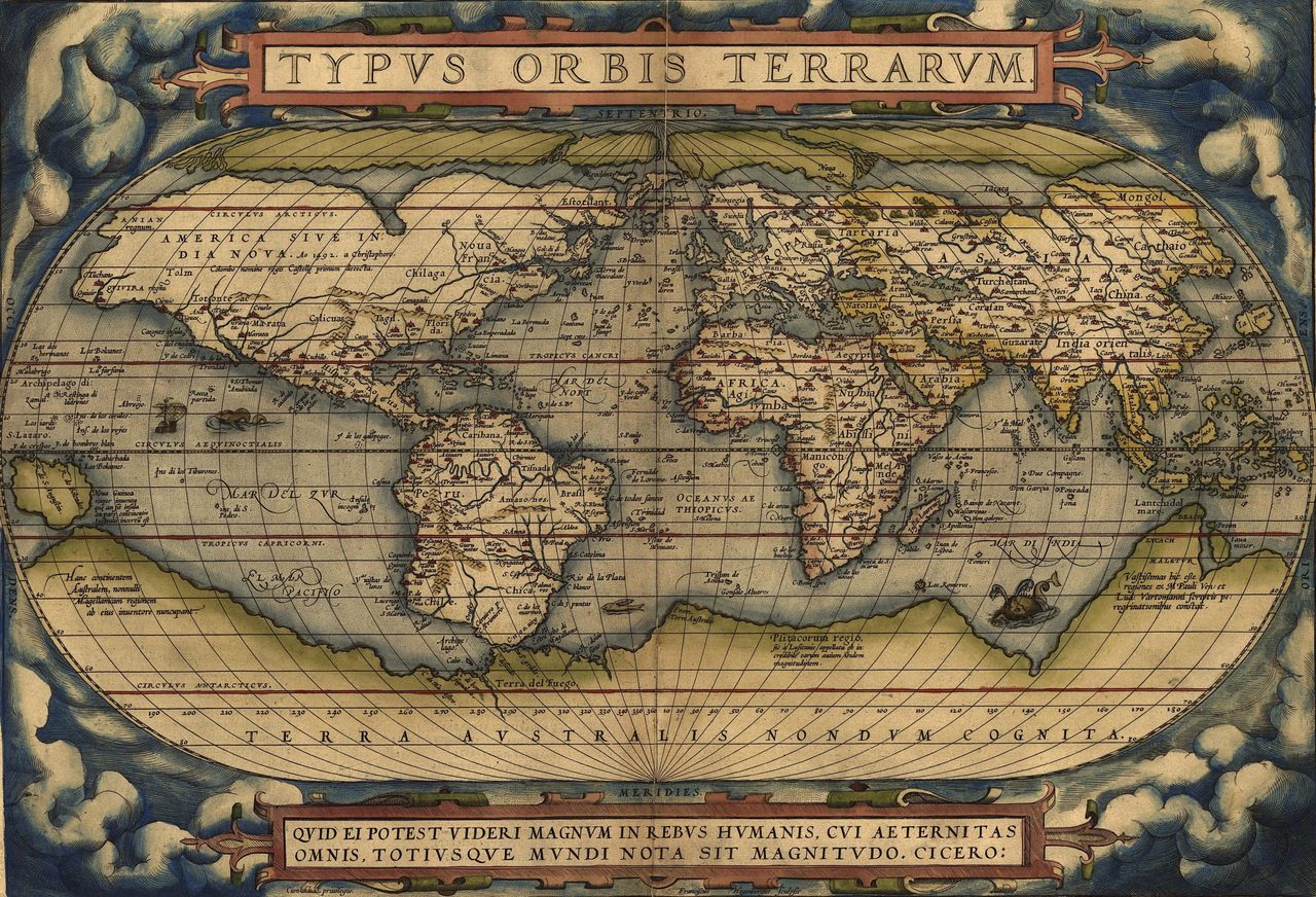
There is also nothing surprising about a southern landmass appearing at all. Terra Australis Incognita, a hypothetical continent invented to “balance” the northern hemisphere, had been drawn onto European maps since Ptolemy in the 2nd century CE. A blank southern shape on a 1513 map is a Ptolemaic placeholder, expected and unremarkable.
| The claimed anomaly | The cartographer's-eye explanation |
|---|---|
| The Amazon is drawn twice | Two source charts of the same coast, both copied in |
| Scale jumps between sections | The 20 sources were drawn at different scales |
| The southern coast bends east | Portolan practice: bend the coast to fit the parchment |
| A southern continent exists at all | Terra Australis, a Ptolemaic placeholder since antiquity |
The specific ice-free-Antarctica reading does not survive contact with the evidence. The coastline Hapgood matched does not actually align with the sub-ice topography of Antarctica revealed by modern surveys; the fit required cherry-picking and ignored the parts that clash. And the geology is fatal: Antarctica’s ice sheet has existed for about 34 million years, since the Eocene to Oligocene transition. An ice-free Antarctica predates our own species by tens of millions of years. There was no one there to map it.
The further extensions, that the source charts were the work of Atlanteans or extraterrestrial visitors, add nothing but a bigger claim resting on the same empty foundation. There is no artifact, no dated source, no map behind the map.
05What is genuinely worth keeping
Debunking the Antarctica story is not the same as dismissing the map. Strip away the lost continent and the Piri Reis map is still doing something quietly remarkable, and the real story is arguably more human than the fringe one.
The map very likely preserves fragments of otherwise lost early exploration charts, including material from Columbus’s own vanished maps and from Portuguese and Spanish voyages. If so, it is a window onto navigational knowledge we would otherwise have no copy of at all. That is historically significant without needing a single ancient astronaut.
It also showcases the depth of the Islamic and Ottoman cartographic tradition. Piri Reis had al-Idrisi, al-Biruni and the whole Ptolemaic inheritance behind him, alongside Arabic coastal knowledge built up over centuries of Indian Ocean and African navigation. The map is a confluence of Mediterranean, Atlantic and Islamic mapmaking, and that is why it looks so unusually rich for 1513.
Fast Facts
- Map
- Drawn 1513 CE, on gazelle parchment
- Maker
- Piri Reis (c. 1465 to 1553), Ottoman admiral
- Rediscovered
- Topkapi Palace library, Istanbul, 1929
- Inventory
- Topkapi Palace Museum, H. 1824
- Compiled from
- ≈ 20 source maps, including lost Columbus charts
- The famous claim
- Southern coast = ice-free Antarctica (Hapgood, 1966)
- Mainstream reading
- Distorted South American coast, bent to fit the parchment
- Antarctic ice age
- ≈ 34 million years, since the Eocene to Oligocene
What we can actually stand behind
The Piri Reis map is real, it is genuinely from 1513, and it is one of the most valuable early charts of the Americas we have, a masterpiece of Ottoman navigation compiled from around 20 older maps.
It very likely preserves scraps of lost source charts, including material from Columbus’s own now-vanished maps. That alone makes it important, and it requires no lost civilization at all.
Hapgood’s broad idea of Ice Age “sea kings” who mapped the globe is unfalsified in the abstract, but no such source map has ever been found, so it stays a story, not a finding.
The specific claim, that the southern coast is an ice-free Antarctica, fails. Antarctica has been under ice for 34 million years, the coastline does not truly match, and the shape is far better read as a distorted South America. We name it and set it down.
And yet the map keeps its grip on us for a reason worth sitting with. Piri Reis told us plainly that he was copying older charts, some of them already lost by his own century. We will never know everything that lay on his desk in 1513. So the honest mystery is not a continent hiding under the ice. It is quieter, and closer to home: how much human knowledge of the world was already old, already copied and recopied, by the time one Ottoman admiral folded it into a single sheet of gazelle skin, and how much of it we have simply let slip away?
Sources & further reading
Everything above is drawn from our research library on Theories of Anything. Open the full files to check the sourcing and go deeper.
Image credits
- The full surviving fragment of the 1513 Piri Reis world map photograph via Wikimedia Commons (Piri Reis (1513); scan held by Topkapi Palace Museum, Istanbul (H. 1824)). Public Domain (PD-old, author's-life-plus-100 expired; pre-1931 publication) Source.
- A detail/crop of the southern portion of the Piri Reis map photograph via Wikimedia Commons (Piri Reis (1513)). Public Domain (PD-old, pre-1931 publication) Source.
- An early modern world map depicting the large speculative photograph via Wikimedia Commons (Abraham Ortelius (1527-1598)). Public Domain (PD-old-100-expired / PD-Art; Creative Commons Public Domain Mark 1.0) Source.
- Card crop of the full surviving fragment of the 1513 Piri Reis world map photograph via Wikimedia Commons (Piri Reis (1513); scan held by Topkapi Palace Museum, Istanbul (H. 1824)). Public Domain (PD-old, author's-life-plus-100 expired; pre-1931 publication) Source.

