The Storegga Slide: The Great Wave and the Drowning of Doggerland
Off the coast of Norway, about eight thousand years ago, a piece of the seafloor the size of a small country tore loose and slid into the deep. Around three thousand five hundred cubic kilometers of sediment, one of the three largest submarine landslides ever found, collapsed down the continental slope and shoved the ocean aside. What it shoved became a wave. That wave crossed the North Sea, ran more than twenty meters up the coast of Shetland, and swept over Doggerland, the low, drowned country that once joined Britain to Europe. For a long time the story ended right there: the Storegga tsunami as the catastrophic final blow that finished Doggerland and cut Britain loose. The newest evidence tells a more complicated and more honest story, one where much of that country was already sinking long before the wave ever arrived. Here is the file, every fact wearing its tier.
There are two stories here, and the honest way to tell them is to keep them apart. The first is about geology: an underwater cliff that collapsed, a wall of water that crossed a sea, and the sand it left behind, and almost all of that is settled beyond serious argument. The second is about people: a drowned country, the hunter-gatherers who lived on it, and exactly what the wave did to them, and that story is genuinely open, and has been actively rewritten in the last decade. The fastest way to cheapen a real catastrophe is to claim we know more about it than we do. So we will read both, tier by tier. Let us open the file.
01The Cliff That Fell Into The Sea
Start with the ground itself, the part that is not in dispute. Off the western coast of Norway, between roughly 63 and 65 degrees north, the continental shelf drops away into the deep Norwegian Sea. At some point in the early Holocene a colossal section of that slope gave way. The Storegga Slide displaced around 3,500 cubic kilometers of sediment, which places it among the three largest submarine landslides ever documented, in the same class as the Agulhas Slide off South Africa and the Nuuanu Slide off Hawaii. The scar it left is visible on the seafloor to this day: a headwall scarp running about 290 kilometers along the shelf edge, up to 35 kilometers wide, with debris that traveled as far as 800 kilometers out across the basin and blanketed roughly 95,000 square kilometers of seabed, at water depths of 200 to 1,500 meters. This is not a theory. It is mapped.
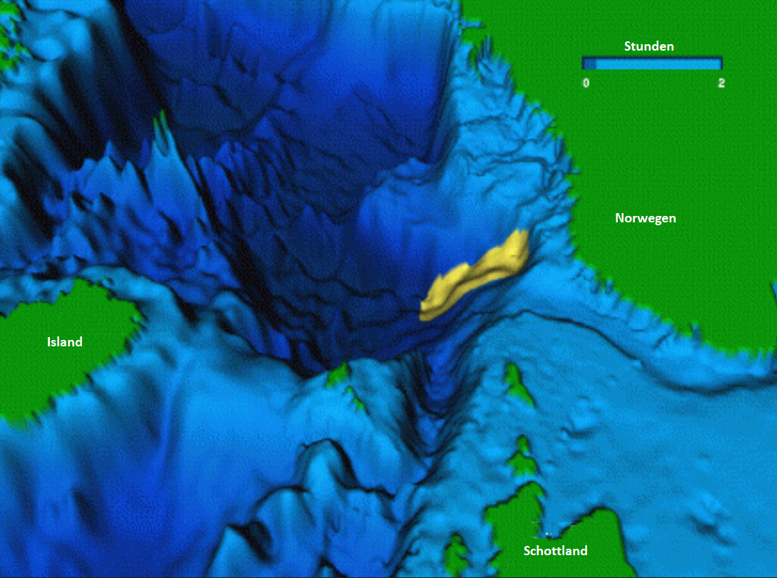
The event that concerns us has a date. The Second, or Main, Storegga Slide is pinned by radiocarbon dating of the tsunami deposits it produced to about 8,150 calibrated years before present, refined by some studies to 8,100 plus or minus 250 years, squarely in the early Holocene. It was not the only one. Geologists have identified at least three major Storegga slides across deep time: a poorly constrained first slide somewhere around 30,000 to 50,000 years ago, this second and best-documented main slide, and additional smaller slides and debris flows both earlier and later. The slope has failed before. It is this main slide, and the wave it launched, that reached across the North Sea and into our story.
02The Wave It Sent
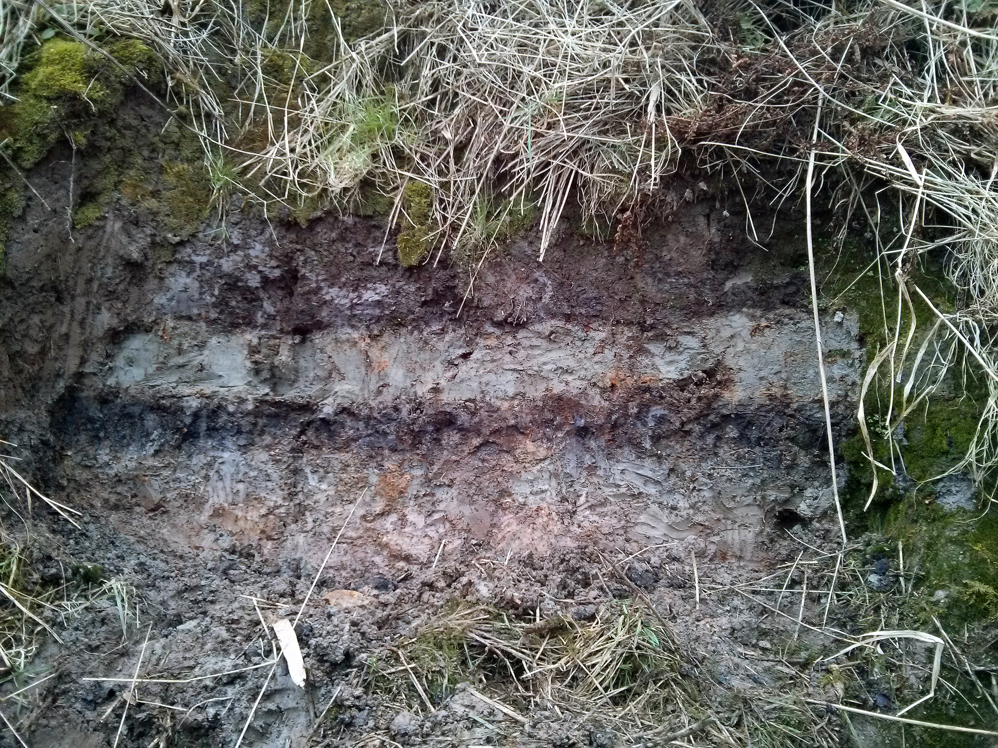
A submarine landslide that big does not just rearrange the seafloor. It shoves the entire water column aside and sends a tsunami radiating outward, and that wave left a signature we can still find and date. Onshore tsunami deposits, anomalous layers of sand, gravel, marine shells and reworked coastal material stranded well above the shoreline, have been documented all around the northern rim of the North Sea. In western Norway, run-up deposits sit 10 to 12 meters above the contemporary sea level, and waves pushed deep inland up the fjords. In northeast Scotland, including the Inverness area, tsunami sand layers are found as high as about 25 meters above present sea level once you account for the land's later isostatic uplift. In the Shetland Islands the deposits are exceptionally well preserved, recording run-up heights of 20 to 25 meters. Even the Faeroe Islands, far out in the North Atlantic, carry inland sand layers full of marine diatoms. This is the physical evidence the whole event rests on.
And these are not just any sand layers. A genuine tsunami deposit has a fingerprint that ordinary storm or river sediment does not: it fines upward from coarse to fine as the water loses energy, it carries marine microfossils like foraminifera and diatoms far inland where they have no business being, it cuts an erosional base into whatever lies beneath it, and it rips up chunks of the underlying peat or soil and carries them along as clasts. When geologists find that exact combination of features at 25 meters elevation in Shetland, they are reading the passage of a single enormous wave.
Numerical models of how the wave propagated, built by Harbitz in 1992 and refined by Bondevik and colleagues in 2005 and Hill and colleagues in 2014, put realistic numbers on it. They predict wave heights of 3 to 5 meters along the eastern Scottish coast and 10 to 20 meters and more of run-up on the Norwegian coast, with significant waves reaching Shetland and Orkney within one to two hours of the slide and crossing the North Sea within three to four hours, striking the eastern English coast and the low-lying Doggerland plains. The models are not a perfect match to every observed deposit, but they are broadly consistent with where the sand actually ended up. Which brings us to the country that was in the way.
03Why The Seafloor Let Go
Why did a stable continental slope suddenly collapse? The honest answer is that it was almost certainly not one cause but several acting together, and this is where the certainty of the geology softens by one notch. During and after the last glaciation, rivers dumped glacially eroded sediment onto the Norwegian slope faster than it could compact and stabilize, building a tall, gravitationally unstable pile. The margin was seismically active as the crust rebounded from the weight of vanished ice, so a triggering earthquake is likely. Warming bottom waters in the early Holocene may have destabilized methane hydrates frozen in the slope sediments, and the gas chimneys and pockmarks pocking the slide scar support that. And running through it all was a specific weak layer: a contourite, a fine glaciomarine clay laid down by bottom currents, with low shear strength, a natural slip plane for everything above it to ride out on.
More recent risk-assessment work, much of it done by the Norwegian Geotechnical Institute in connection with the Ormen Lange gas field that now sits in the slide scar, has refined rather than overturned that picture. The current synthesis treats the thick pile of glacially derived sediment as the primary underlying precondition, an earthquake as the probable immediate trigger, and gas hydrate breakdown as a real but more localized, secondary contributor to the loss of sediment strength, rather than the single driving force it was sometimes cast as. The pieces are the same. Their relative weight has shifted.
04The Country Under The North Sea
To understand what the wave hit, you have to picture a place that no longer exists above water. Doggerland was a real, inhabited landscape in what is now the southern and central North Sea, filling the space between Britain, the Netherlands, Denmark and Norway. At its greatest extent during the Last Glacial Maximum, roughly 26,000 to 19,000 years ago, when global sea level stood about 120 to 130 meters lower than today, it covered on the order of 23,000 square kilometers of dry land, and by some estimates closer to 46,000 if you count the shallow margins. This is not folklore. Fishing trawlers have been dragging its remains up off the seabed for over a century: barbed bone points, mammoth remains, tree stumps, peat, worked stone tools, and even fragments of human skull.
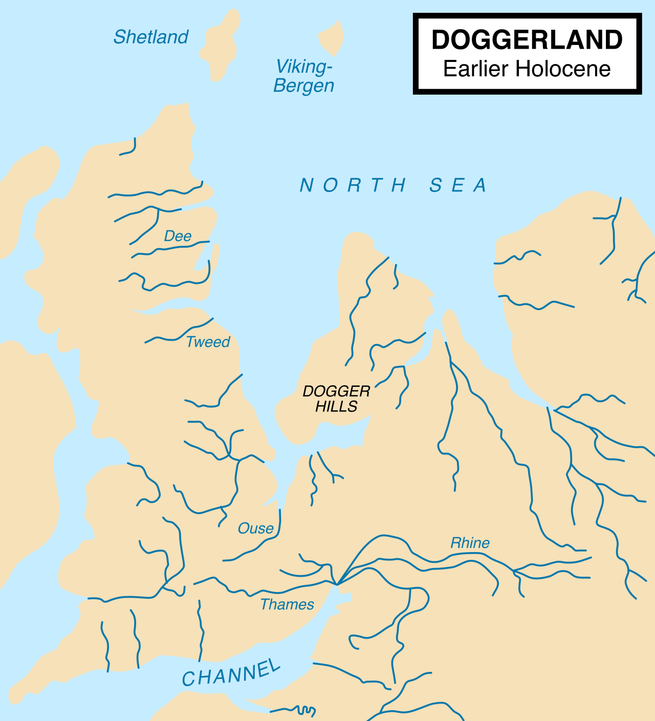
The Dogger Bank, a large sandbank that ships still navigate around, is the drowned high ground of that country, and it preserves the ghost of an entire landscape of river valleys, lakes, marshes and hills. The Europe's Lost Frontiers Project at the University of Bradford has used seismic survey and multibeam bathymetry to reconstruct those buried paleo-landscapes in remarkable detail, mapping rivers and coastlines no human eye has seen in eight thousand years. Submerged forest stumps and peat beds dated to roughly 8,000 to 6,000 BCE still lie off the Norfolk and Yorkshire coasts, and trawler catches routinely bring up Mesolithic barbed antler points, worked flints and animal bone from the seabed.
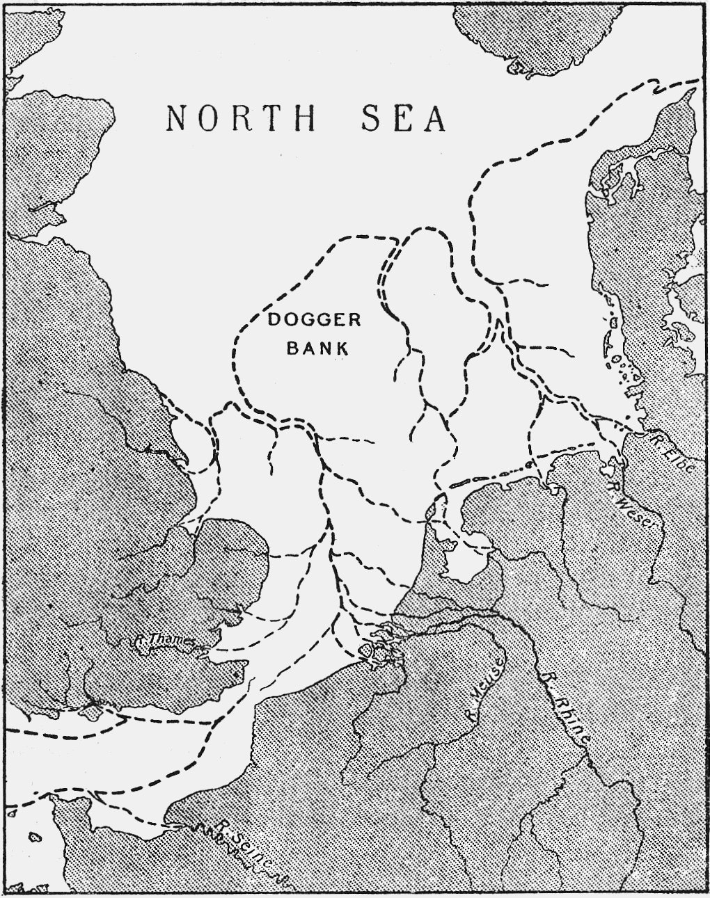
People and animals were there for a very long time. The Brown Bank, a shoal midway between England and the Netherlands, has yielded abundant Paleolithic and Mesolithic artifacts, and Hansson and colleagues mapped a preserved Mesolithic landscape about 15 meters down on it, its sediment sequences and organic remains still intact. A Neanderthal skull fragment dredged from the North Sea floor, dated to around 40,000 years ago, shows that earlier humans, a different species entirely, occupied the region tens of thousands of years before the Mesolithic hunter-gatherers this story is really about. Mammoth, woolly rhinoceros, giant deer and aurochs bones come up from the Dogger Bank as a matter of routine.
And this was not some marginal land bridge that people merely crossed. Gaffney and colleagues argued in 2009 that Doggerland was a heartland of Mesolithic Europe, a low-lying, well-watered, game-rich landscape that would have been prime territory for hunter-gatherers, not a corridor but a destination. In 2020 the same team identified a large inland lake in the southern North Sea, the Outer Silver Pit Lake, exactly the kind of freshwater feature that draws people and game. The slow drowning of this country, they suggest, may have been one of the largest forced migrations in European prehistory, potentially displacing tens of thousands of people over some two thousand years, though that population figure is offered as a hypothesis, not a headcount.
The drowning itself was part of a global process, and the numbers matter for what comes next. At the Last Glacial Maximum, sea level was 120 to 130 meters below where it is now. It did not rise steadily. Meltwater Pulse 1A, around 14,600 years ago, delivered roughly 20 meters of rise in about five centuries. The Younger Dryas cold snap, from about 12,900 to 11,700 years ago, slowed it to a near pause. Then Meltwater Pulse 1B, around 11,300 years ago, added about 15 more meters in three centuries. By roughly 6,000 years ago the sea had climbed to within 2 to 3 meters of its present level. Doggerland was being eaten by that rising water for thousands of years. The tsunami arrived, at about 8,150 years ago, in the middle of an inundation that was already well underway.
| Measure | The Figure | For Scale |
|---|---|---|
| Sediment displaced | ~3,500 cubic km | Among the three largest submarine slides on record |
| Headwall scarp | ~290 km long, up to 35 km wide | Along the Norwegian shelf edge |
| Debris run-out | Up to ~800 km | Blanketing ~95,000 sq km of seabed |
| Date of the main slide | ~8,150 years ago | Early Holocene |
| Tsunami run-up | 20 to 25 m in Shetland, ~25 m near Inverness | A wave, not a storm surge |
| Time to cross the North Sea | ~3 to 4 hours | Shetland and Orkney within 1 to 2 hours |
05The Old Story: The Final Blow
For years the story had a clean, dramatic ending, and it came mainly from one influential paper. Weninger and colleagues, in 2008, modeled the Storegga tsunami sweeping across what was left of Doggerland and concluded that the wave would have crossed the remaining land surface within four to six hours, with virtually no high ground anywhere to offer refuge. On a landscape whose islands rose only a few meters above the sea, a wave of 3 meters or more would have been devastating. Weninger's team, and Gaffney's, proposed that this was the decisive event, and Weninger's paper says so in its very title: the catastrophic final flooding of Doggerland, the blow that permanently severed the last land connection between Britain and the continent and helped set Mesolithic Britain on its own genetic and cultural path. It is a powerful image, and it is still the version most people have heard: the great wave that drowned a country in an afternoon.
Even the corpus that tells that older story adds a quiet qualifier, and it turns out to matter enormously. By 8,150 years ago Doggerland was already largely gone, reduced to remnant islands and coastal fringes with the Dogger Bank as its last high ground, and ordinary post-glacial sea-level rise would very likely have swallowed those remnants within a few more centuries regardless of any wave. The tsunami hit a country that was already most of the way to the bottom of the sea. That single admission is the hinge on which the whole modern debate turns.
06The New Reading: A Land Already Drowning
In 2020, Walker and colleagues published 'A great wave: the Storegga tsunami and the end of Doggerland?' in the journal Antiquity, and for the first time it presented tsunami evidence recovered from the floor of the southern North Sea itself, not just from the Scottish and Norwegian coasts. Their finding complicated the tidy picture in an important way. The tsunami's impact, they concluded, was highly contingent upon landscape dynamics: it varied dramatically from place to place, with areas sheltered by topography suffering little while exposed shores were hammered. And their headline conclusion cut directly against the old framing. The eventual inundation of the remaining parts of Doggerland, they wrote, resulted from the inexorable sea-level rise, rather than a lasting inundation from the Storegga tsunami. The wave was real and locally violent. But in their reading it was not what finished Doggerland. The rising sea was.
Three years earlier, in 2017, Hill and colleagues had reached a compatible conclusion by a different route. Using numerical models that folded in the real uncertainty about what the ancient seafloor looked like, they simulated the slide and tracked the wave, and found lower inundation levels than the sediment-based assumptions had implied. Their conclusion, in a paper titled 'Was Doggerland catastrophically flooded by the Mesolithic Storegga tsunami?', was that the abandonment of Doggerland was primarily caused by rapid sea level rise prior to the tsunami event, not by the wave. One honest caveat belongs on this one: that paper is available as an arXiv preprint and was reportedly submitted to a journal, but this file could not independently confirm its final peer-reviewed publication, so it is cited here as a preprint and weighed accordingly.
And the most recent and most careful word on the human question is the most cautious of all. In 2021, Nyland, Walker and Warren published an archaeological review in Frontiers in Earth Science with a deliberately skeptical title: 'Evidence of the Storegga Tsunami 8200 BP?' They went looking, site by site, for the tsunami's mark on Mesolithic people, and they found startlingly little. There is, they concluded, very little archaeological data showing direct effects on Mesolithic populations, and no skeletal remains or definitive mortality evidence anywhere in the record. Demographic models do show population wobbles around 8,200 years ago, but researchers cannot even agree whether the tsunami or the concurrent 8.2 ka climate cooling event caused them. Reviewing specific sites, Castle Street at Inverness, Broughty Ferry, and Nyhamna, they noted occupation both before and after the event, with the tsunami deposits sitting in nearby wetlands rather than in the settlements themselves, so that direct traces of impact at the occupation sites were not identified at most of them. Their summary line is one every honest account should carry: it is difficult to gauge what the impact of the tsunami was without making bold assumptions.
07The Quarter That Was Never Counted
You have very likely heard a specific, grim number attached to this event: that up to a quarter of the Mesolithic population of Britain lost their lives in the Storegga tsunami. It is a striking figure, and it deserves to be handled honestly, because it does not come from where people assume. Traced to its source, the quarter-of-Britain figure appears in a 2020 article in The Independent by the journalist David Keys, headlined 'How a giant tsunami devastated Britain's Atlantis.' It is cited as exactly that, footnote and all, on the event's own Wikipedia page. It is not the finding of any peer-reviewed population or mortality study this file could locate. That does not make it impossible. It makes it a journalist's vivid estimate, not an established scientific result, and those are not the same thing.
The peer-reviewed record is far more restrained, and it pulls in the opposite direction. In northeast Scotland the tsunami did strike areas where Mesolithic shell middens and habitation sites are known, and at Inverness the deposit sits at elevations close to those of Mesolithic occupation layers. But direct evidence of casualties or destroyed settlements has simply not been recovered. As the archaeologist Caroline Wickham-Jones has put it, it would be nice to find the remains of squashed Mesolithic people under the tsunami deposit, but the force of the event makes that unlikely, and where deposits do overlie known sites, it is impossible to be sure of the relationship between the two. Set that beside the 2021 review's finding of very little archaeological data for direct human impact, and the quarter-of-Britain figure stands exposed for what it is: a number with a newspaper behind it, not a graveyard.
The genetic evidence, so often invoked, cannot rescue the dramatic version either, because for this specific question it barely exists. No ancient DNA has ever been recovered from a human being on Doggerland, for the simple reason that the landscape is entirely underwater and beyond ordinary excavation, and no human skeleton from the drowned land has been found at all. Everything trawled up that is human is either artifact or, in the one case, that far older Neanderthal skull fragment. What we do know about Mesolithic Britain's genetics comes from people buried on dry land, above all Cheddar Man from Gough's Cave in Somerset, who lived around 10,000 years ago, before Storegga, and whose genome sits firmly within the Western Hunter-Gatherer population documented across Mesolithic Western Europe. No published study has yet traced genetic continuity or rupture across the Storegga window itself. The idea that the wave severed Britain genetically is a reasonable hypothesis. It is not a measured result.
08What The Toolkit Looked Like
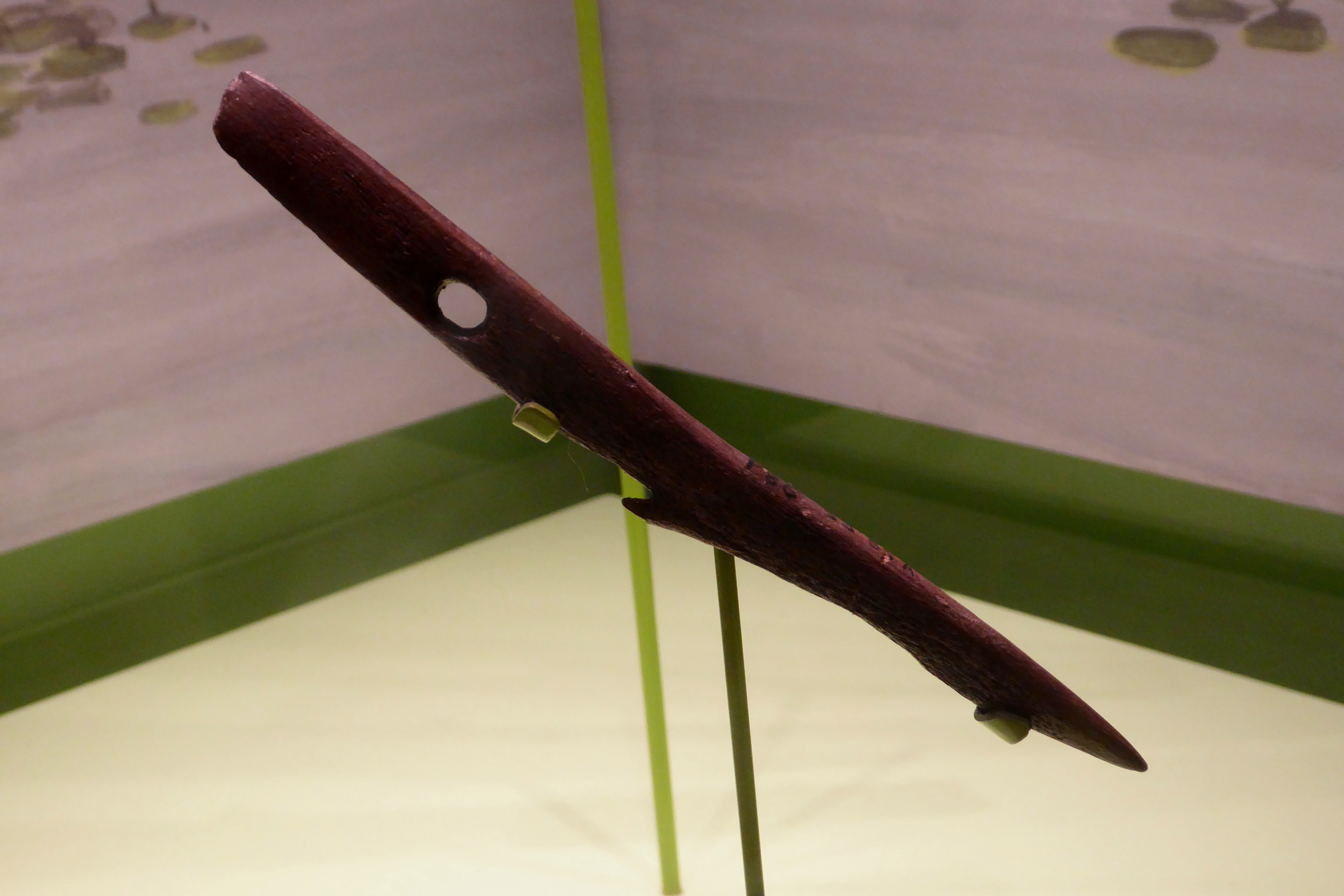
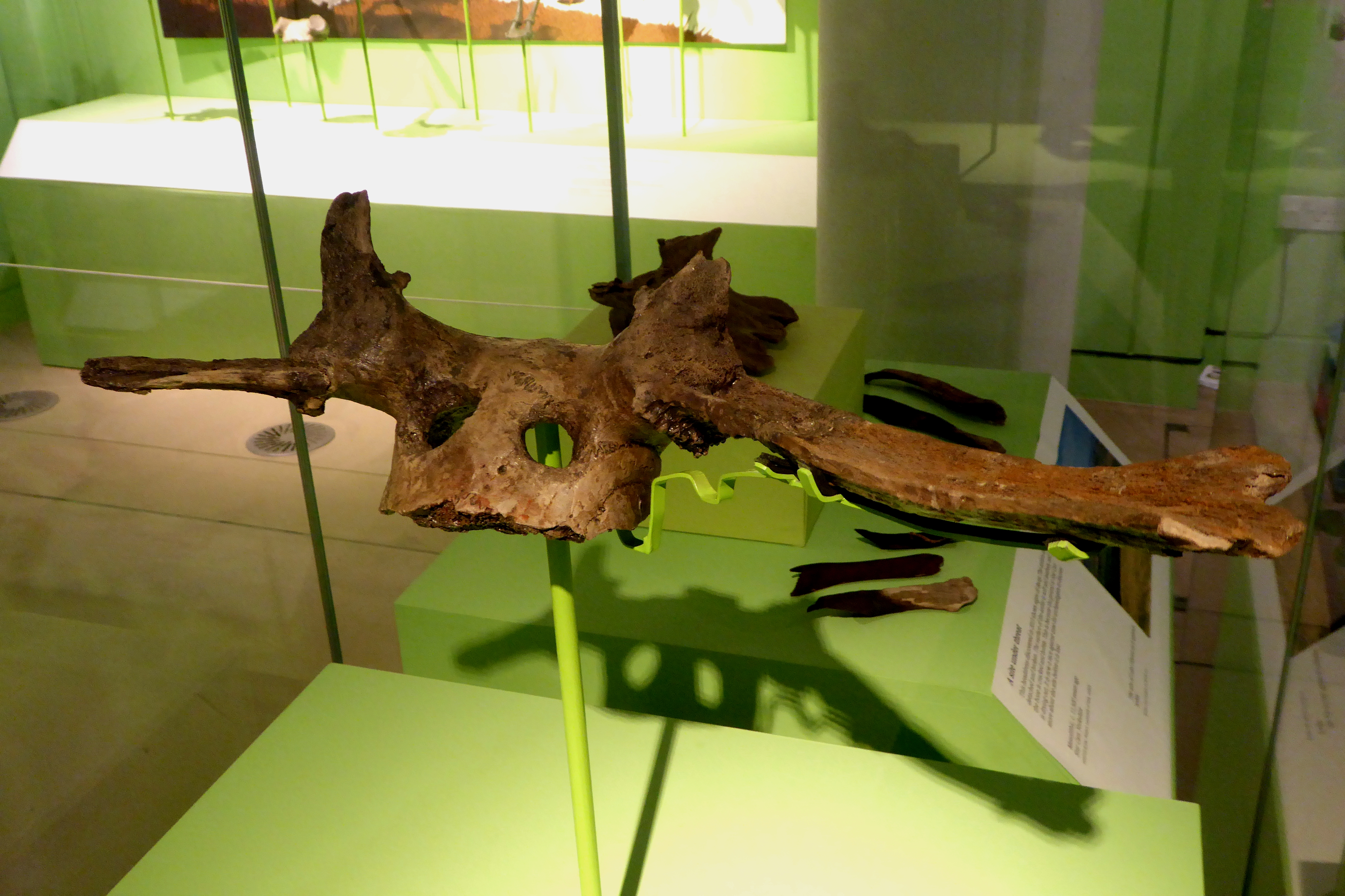
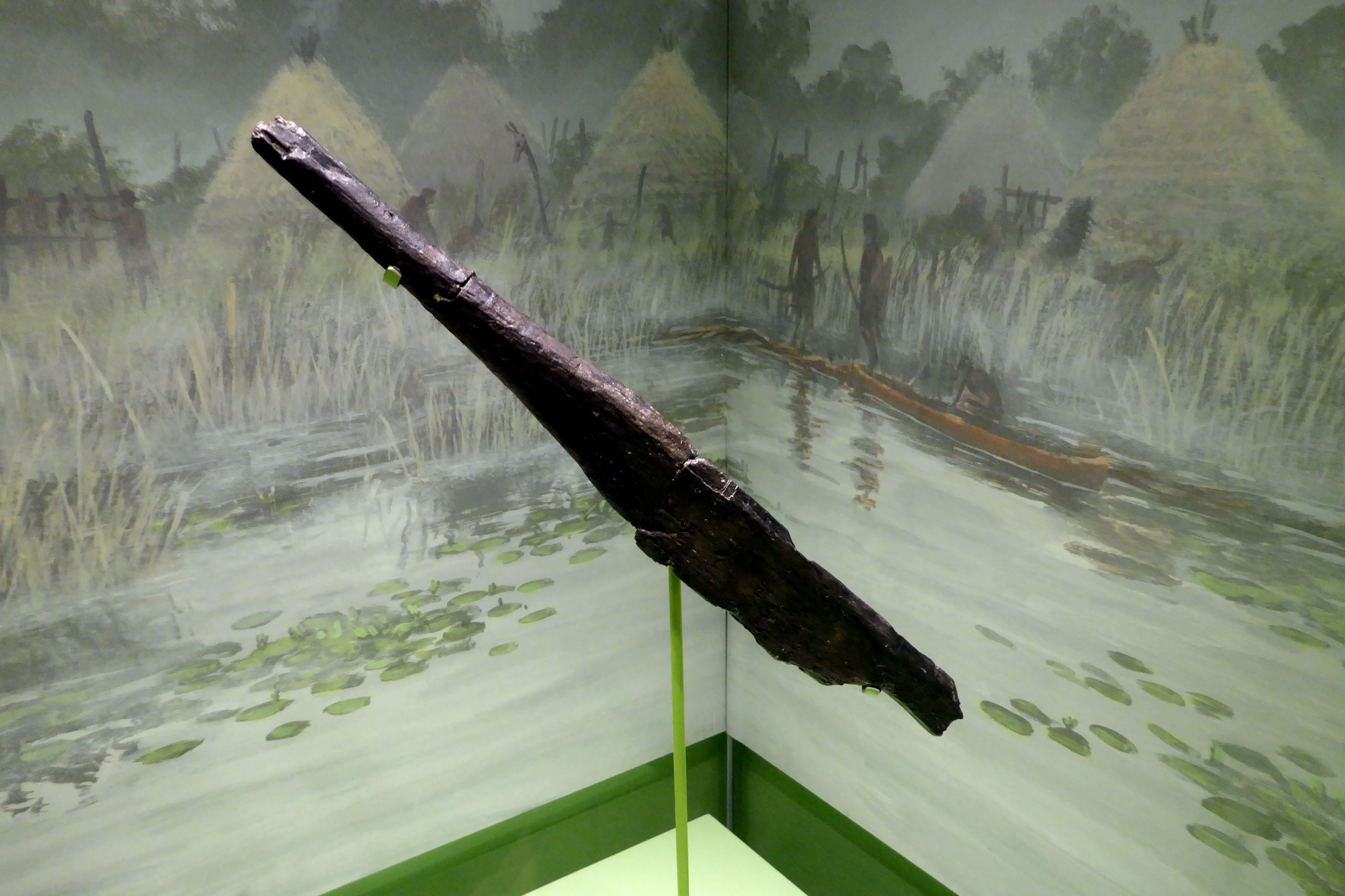
So what did these people actually leave behind, and here we have to be scrupulously careful, because the richest evidence is not from Doggerland at all. The best window into the material culture of this broader North Sea Mesolithic world is Star Carr, a site in North Yorkshire occupied roughly 9,300 to 8,480 BCE. Its waterlogged ground preserved organic objects that almost never survive: a barbed antler harpoon and a wooden paddle, both dated to about 11,500 years ago, plus 195 barbed antler points, which is more than 95 percent of every such point known from the entire British Mesolithic, and 33 antler frontlets, red deer skull caps worked and bored with attachment holes, which researchers interpret as either shamanic ritual headwear or hunting disguises. The paddle matters especially, because it means these were boat-using people, at home on water, in a world of rivers, lakes and marsh. But here is the honesty this deserves. Star Carr is not Doggerland. It sits on dry land in Yorkshire, and it was already abandoned for something like two to three thousand years before the Storegga wave ever formed. These objects are not tsunami victims and they are not Doggerland finds. They show us the toolkit and the technology of the wider culture, the same kind of barbed points that do come up directly from the Doggerland seabed, but they are a picture of how these people lived, not a photograph of how any of them died.
09Could Anyone Have Remembered?
Could a memory of the wave have survived? It is a genuinely tempting question and an honestly speculative one. More than eight thousand years is far beyond the span over which oral tradition is usually thought to preserve real events, and the corpus is explicit that this is speculation. Still, some scholars have wondered aloud whether certain northern European flood myths might encode a distant folk memory of the North Sea's drowning. There is no confirmed tradition anywhere that can be shown to describe the Storegga event itself. On its own, the idea sits at the soft edge of the evidence.
What keeps it from being pure wishful thinking is that, in other parts of the world, oral memory of coastal catastrophe demonstrably has survived across such spans. On Simeulue Island, a tradition called smong, carried down from a 1907 tsunami, is credited with saving all but seven of some 78,000 people when the wave came again in 2004. Pacific Northwest First Nations preserved accounts of the great Cascadia earthquake of January 1700, which were later matched precisely to drowned ghost forests and to a documented orphan tsunami recorded in Japan. And researchers have catalogued at least 21 Aboriginal Australian oral traditions that appear to describe real coastal inundation from between roughly 7,000 and 12,000 years ago. None of these is about Storegga. What they prove is only that the general phenomenon is real, that human memory can, under the right conditions, carry the shape of a catastrophe across hundreds of generations. Whether it did so for the North Sea remains, honestly, unknown.
10Will It Happen Again?
There is a practical reason people still study this closely: the Norwegian margin now carries major oil and gas infrastructure, including the Ormen Lange field sitting in the old scar, and a repeat would be a genuine hazard. The reassuring news is that the specific conditions that produced the historic slide are not clearly present today. Sediment is accumulating on the margin far more slowly than it did in the frantic centuries just after deglaciation, and the particular weak clay layer that let the slope ride out may not exist in the current sediment column. Risk assessments, including work tied to the Ormen Lange development, conclude that a repeat of the same magnitude is unlikely on the scale of centuries to millennia, though it cannot be ruled out over longer spans, with a full recurrence judged most plausible only after some future glaciation rebuilds the sediment pile. Not never. Just not soon.
11What This Is Not
Because this is a site that takes a real catastrophe seriously, it has to be equally clear about the two false ones that always get bolted onto it.
No, the Storegga tsunami was not the real Noah's Flood, and the fit is not even close. The event was regionally devastating, confined to the lands around the North Sea and the northeast Atlantic. It did not, and physically could not, produce a global inundation. Its date, around 8,150 years ago, and its geography, the North Sea rim, do not line up with the Near Eastern setting of the Flood tradition. A regional wave is not a worldwide deluge, and calling it one gets both the science and the story wrong.
And no, Doggerland was not Atlantis, however irresistible the shorthand. Doggerland was gloriously real, a genuine drowned country under a real sea, and that is exactly why it is worth studying. But its inhabitants were mobile Mesolithic hunter-gatherers, not the citizens of a wealthy island empire with harbors and temples. There is no trace of urban civilization anywhere in it, because there was none. Its end was a slow drowning across millennia, punctuated by a wave, not the overnight destruction of a great power such as Plato described. 'Britain's Atlantis' makes a fine documentary title, and the BBC has used it more than once, but the comparison teaches one true thing and one false one. True: real inhabited landscapes have been swallowed by the sea. False: that any of them was Plato's.
12Every Claim, Every Tier
Here is the whole file on one page, each claim wearing its tier, because the surest way to ruin an honest story like this one is to let rock-solid geology, a genuinely open scholarly debate, a newspaper's estimate, and two flat myths all blur into one legend. They are not the same, and the tiers are what keep them apart.
| The Claim | Tier | The Basis |
|---|---|---|
| A ~3,500 cubic km submarine slide struck off Norway ~8,150 years ago | Tier 1 | Seafloor mapping and radiocarbon dating |
| The slide sent a tsunami across the North Sea | Tier 1 | Dated deposits from Norway to Scotland to the Faeroes |
| Shetland recorded 20 to 25 m of tsunami run-up | Tier 1 | Bondevik et al. field deposits |
| Doggerland was a real, inhabited drowned landscape | Tier 1 | Trawled artifacts, bone, and seismic mapping |
| Sea level rose 120 to 130 m since the LGM, drowning Doggerland | Tier 1 | The meltwater-pulse and sea-level record |
| The slide's trigger was a combination of causes | Tier 2 | Sediment loading, quake, hydrates, weak clay |
| Weninger 2008: the wave was Doggerland's catastrophic final blow | Tier 2 | The older, now-contested framing |
| Walker 2020 and Hill 2017: the sea, not the wave, ended Doggerland | Tier 2 | Newer peer-reviewed and preprint work |
| The wave's impact on Doggerland's people was severe | Tier 2 | Plausible, but not directly evidenced |
| A quarter of Britain's Mesolithic population died | Tier 3 | A 2020 newspaper estimate, not a study |
| Storegga survives in a northern European oral tradition | Tier 3 | No confirmed Storegga-specific tradition |
| Another Storegga-scale slide could recur | Tier 3 | Unlikely soon, not excludable long-term |
| The Storegga tsunami was Noah's Flood | Tier 4 | Regional, not global; wrong place and time |
| Doggerland was Atlantis | Tier 4 | No cities, no empire; a slow drowning, not Plato's |
Fast Facts
- The Slide
- ~3,500 cubic km of Norwegian seafloor, among the three largest submarine slides known
- The Date
- ~8,150 years ago, in the early Holocene
- The Wave
- A tsunami across the North Sea, run-up of 20 to 25 m in Shetland
- The Cause
- Sediment loading, a likely earthquake, methane hydrates, and a weak clay slip layer
- The Country
- Doggerland, a real drowned landscape once linking Britain to Europe
- The Old Story
- The wave as Doggerland's catastrophic final blow (Weninger, 2008)
- The New Reading
- The sea was already drowning Doggerland; the wave's role was local and variable (2017 to 2021)
- The Disputed Number
- 'A quarter of Britain's Mesolithic population' traces to a 2020 newspaper, not a study
- What It Is Not
- Not Noah's Flood, not Atlantis
- The Verdict
- The geology is certain; the human toll is genuinely open; the myths are false
What We Can Actually Stand Behind
The slide and the wave are beyond dispute. A submarine landslide of roughly 3,500 cubic kilometers off Norway, one of the three largest known, failed around 8,150 years ago and sent a tsunami across the North Sea, recorded in dated deposits from the Norwegian fjords to a 25-meter run-up in Shetland to inland sand in the Faeroe Islands. Doggerland was a real, inhabited landscape, its remains trawled from the seabed and mapped by seismic survey, and post-glacial sea-level rise of well over a hundred meters was drowning it for thousands of years. All Tier 1.
How the slope failed, a combination of sediment loading, a probable earthquake, methane hydrates and a weak clay layer, is well reasoned but not pinned to a single cause. And the central human question is a live debate, not a settled fact. The older framing (Weninger, 2008) cast the wave as Doggerland's catastrophic final blow. The newer work (Walker and colleagues, 2020; Hill and colleagues, 2017, cited as a preprint) reads the same evidence differently: the tsunami was locally violent but geographically variable, and it was the relentless rise of the sea, not the wave, that finished the country. Both are serious positions. The field has not closed the question, and the most careful review to date warns against making bold assumptions about the human toll.
Some claims are not yet earned. The widely repeated figure that a quarter of Britain's Mesolithic population died traces to a 2020 newspaper article, not a peer-reviewed study, and the peer-reviewed archaeology has recovered no casualties at all. Whether any oral tradition preserves a memory of the wave is unknown, even though such memory demonstrably survives elsewhere in the world. And another slide could recur, though not likely soon.
Two readings are simply wrong, so say it plainly. No, the Storegga tsunami was not Noah's Flood: it was regional, not global, and neither its date nor its geography fits the Near Eastern tradition. And no, Doggerland was not Atlantis: it held mobile hunter-gatherers, not a lost empire, and it drowned slowly over millennia rather than vanishing in a day. A real drowned country is not a myth, and it does not need to borrow one.
So hold the layers apart, and the story becomes both smaller and stranger than the legend. There was a real wall of water, and it really did cross a real sea and break over a real drowned country. But that country was already going under, slowly, for reasons that had nothing to do with any single afternoon, and the wave may have been less an ending than a violent moment inside a much longer drowning. We can map the slide to the cubic kilometer. We cannot yet count a single person it killed. That gap, between what the rock records perfectly and what it refuses to tell us about the people who were there, is the honest center of this whole file. Somewhere under the North Sea lies the evidence that would close it. How much of a lost world are we willing to go down and read?
Sources & further reading
Everything above is drawn from our research library on Theories of Anything, which is where we worked from. The papers, reports and primary records listed beneath them are where you can check us independently.
Image credits
- Storegga Tsunami Deposit, Montrose Basin, Scotland photograph by Stozy10 via Wikimedia Commons. CC BY-SA 3.0 Source.
- Map of the Storegga Slide, Norwegian Continental Shelf map by Matias Hanisch via Wikimedia Commons. CC BY-SA 3.0 Source.
- Map of Doggerland map by Max Naylor via Wikimedia Commons. CC BY-SA 3.0 / GFDL Source.
- Clement Reid's 1913 Map of the Dogger Bank Submerged Forest map by Clement Reid, from Submerged Forests, 1913, via Wikimedia Commons. Public Domain Source.
- Mesolithic Barbed Antler Harpoon from Star Carr photograph by Ethan Doyle White via Wikimedia Commons. CC BY-SA 4.0 Source.
- Mesolithic Antler Headdress from Star Carr photograph by Ethan Doyle White via Wikimedia Commons. CC BY-SA 4.0 Source.
- Mesolithic Wooden Paddle from Star Carr photograph by Ethan Doyle White via Wikimedia Commons. CC BY-SA 4.0 Source.
- Card crop of Storegga Tsunami Deposit, Montrose Basin, Scotland photograph by Stozy10 via Wikimedia Commons. CC BY-SA 3.0 Source.
.jpg)


