The Eye of the Sahara: Atlantis, or an Eroded Dome?
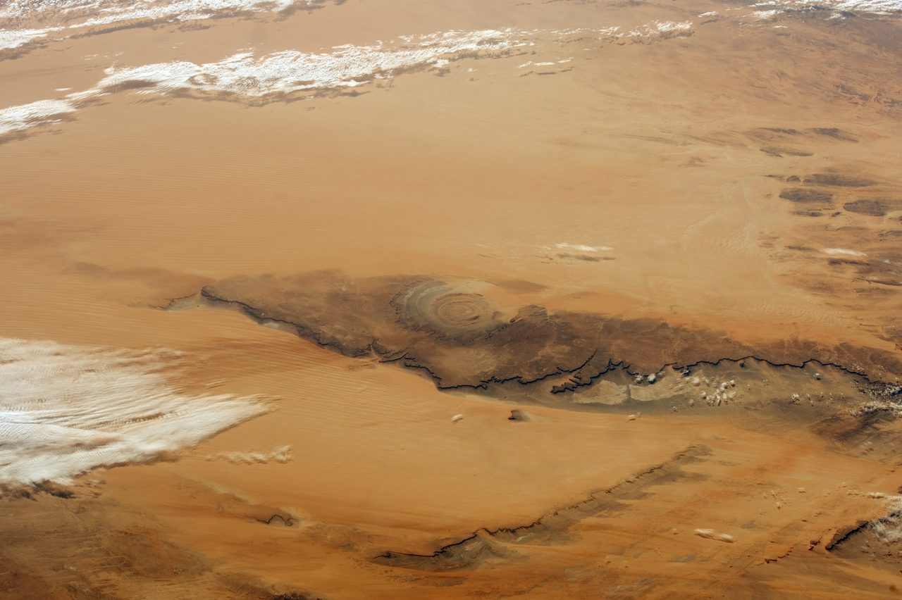
In the west-central Sahara sits a near-perfect bullseye of rock, forty to fifty kilometers across, so sharp that Gemini astronauts noticed it from orbit in the 1960s. Its concentric rings look engineered, and a popular strand of alternate history insists they are: this, it argues, is Plato's Atlantis. Geologists tell a settled and far older story. The Eye is a magmatic dome roughly a hundred million years in the making, its rings the eroded edges of tilted rock, and it has stood as dry land, some four hundred meters above the sea, since long before any city was built. Here is the file, opened claim by claim, every fact wearing its evidence, and one honest question left standing at the end.
Some places on Earth look designed. The Eye of the Sahara is the loudest of them. Seen from orbit it is a bullseye, ring inside ring inside ring, dropped into an ocean of empty desert with a precision that feels deliberate. It is real, you can pull it up on any satellite map, and its official name is the Richat Structure. For most of a century it has drawn two very different crowds: geologists who wanted to know how a target that big got carved into rock, and a far larger online audience convinced the target is the ruin of a drowned city. One of those crowds has closed its case. Let us open the file.
01The Bullseye You Can See From Orbit
The Eye is not small and it is not subtle. The Richat Structure, also called the Eye of the Sahara or Guelb er Richat, is a circular formation about forty to fifty kilometers across, set on the Adrar Plateau in west-central Mauritania at 21 degrees 07 minutes north, 11 degrees 24 minutes west. Its rings are concentric and stacked: the outermost measures forty to fifty kilometers, and the innermost core is about three kilometers wide. That is a target you could not take in from a hilltop, which is exactly why it stayed a curiosity until people began looking down at it from space.
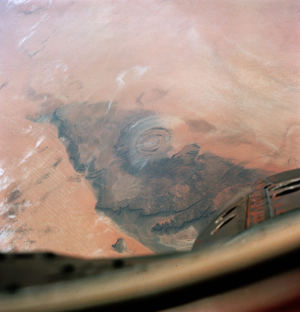
Nobody drew the Eye on a map from the ground. Its scale and its flatness make the ring pattern almost impossible to read while you are standing inside it. The structure was first noticed by NASA's Gemini astronauts in the 1960s, who spotted the bullseye from orbit, and it has been one of the most photographed geological features on the planet ever since. The pictures are the whole reason the legend exists. A shape this clean, this circular, this obviously patterned, begs to be explained, and for a long time nobody was sure how nature had made it.
02What The Rock Actually Is
Up close, the rings are rock. The structure is built from layers of Proterozoic to Ordovician sedimentary rock, quartzite, limestone, dolostone, shale, and siltstone, that were pushed up and tilted by a dome swelling underneath them. As the raised layers wore down, the hard bands like quartzite and limestone survived as ridges while the soft bands like shale and siltstone eroded into troughs. That alternation of tough and weak rock, seen from above, is the bullseye. The rings are not walls, and they are not channels. They are the sawn-off edges of tilted strata.
The dome had a fiery core. Several generations of igneous rock sit inside the structure, ranging from rhyolite to gabbro in composition, along with carbonatite dikes and sills, and those intrusions have been dated. Argon-argon and uranium-lead methods put the carbonatite at about 99 million years old, give or take 2 million, deep in the Late Cretaceous, back when dinosaurs still walked. This is a Late Cretaceous feature, not a young one, and not a built one.
Put together, the story is unglamorous and complete. In the Late Cretaceous, about 99 million years ago, magma rising from below lifted the overlying stack of sedimentary rock into a gentle dome. Then time and weather went to work. Over roughly 100 million years, erosion stripped away the top of the dome and exposed ring after concentric ring of rock, alternating resistant and non-resistant layers all the way down. There is no missing step and no unexplained gap. A dome, uplifted and then patiently unroofed, produces exactly the pattern the satellites see.
Geologists still fill in detail around that core story. The doming was probably alkaline-magmatic, possibly tied to the same carbonatite and kimberlite volcanism that left the dikes, and hydrothermal fluids moving through the rock added their own dissolution and collapse, complicating the structure further. These are refinements to the model, not rivals to it. Every one of them keeps the Eye firmly natural.
Where working geologists genuinely disagree is on the number of acts. Some argue the Eye is not the product of a single event but of several, with the Proterozoic basement rocks in the core possibly recording an older deformation that the Cretaceous magmatism later reactivated. A structure with a long memory, in other words, uplifted more than once.
There is a real chemical puzzle here too. The complex holds both alkaline igneous rocks, like carbonatite and phonolite, and calc-alkaline ones, like rhyolite and gabbro, together in one place, which is unusual and may point to a complicated magmatic history still being worked out. Notice what these open questions are about. They are about how the magma behaved, not about who built a city. The frontier at the Eye is petrology, not archaeology.
| Feature | What Is Actually Known |
|---|---|
| Location | Adrar Plateau, west-central Mauritania (about 21 N, 11 W) |
| Diameter | About 40 to 50 km across; inner core about 3 km |
| Rock | Proterozoic to Ordovician sedimentary layers over a magmatic dome |
| Age Of Intrusion | Carbonatite dated to about 99 million years (Late Cretaceous) |
| Formation | Magmatic uplift, then roughly 100 million years of erosion |
| Elevation | About 400 m above sea level; dry land since the Paleozoic |
| First Seen From Space | Gemini IV, 1965 |
03The Impact Idea, Raised And Ruled Out
A circle that big invites big theories, and the first serious one was not Atlantis, it was a meteorite. In 1974 Dietz and McHone proposed that the Richat Structure was an impact crater, reading its round shape and its shattered central rock as the scar of something falling out of the sky. It was a reasonable guess for its day. Round structures with brecciated cores really can be impact scars. The way to find out is to look for the fingerprints an impact leaves, and those fingerprints are specific.
So people looked, and the fingerprints were not there. The shattered rock in the center turned out to be silicification and dissolution breccia produced by hot fluids rather than shock, the same hydrothermal process documented in domed structures worldwide. A high-pressure mineral once claimed as impact evidence, coesite, was shown to be a misidentification (Fudali, 1969). And the systematic study by Matton and colleagues, published in the journal Geology in 2005 and expanded in 2008, closed the question: no shocked quartz, no coesite or stishovite, no genuine shatter cones (the suspected ones proved to be ordinary sedimentary features), and no geochemical impact signature, with iridium and other siderophile elements sitting at perfectly normal levels.
| Impact Fingerprint | What The Eye Shows |
|---|---|
| Shocked quartz (planar deformation features) | Absent in every quartz grain examined |
| High-pressure minerals: coesite, stishovite | None; an early coesite claim was a misidentification |
| Shatter cones | The suspected cones proved to be normal sedimentary features |
| Iridium and siderophile geochemistry | Normal levels, no impact signature |
That leaves one standing explanation, and it is not controversial. The current geological consensus is that the Eye of the Sahara is a deeply eroded, slightly lopsided dome, probably a laccolith or a diapir, of magmatic origin, whose bullseye look is simply differential erosion of tilted sedimentary layers. This matters for what comes next. The impact hypothesis was raised, tested, and rejected on the evidence, which is science working exactly as it should. It is worth contrasting with a case like the Younger Dryas impact hypothesis, which genuinely does remain open elsewhere in our library. At the Eye, there is no open impact question left to argue.
04The Green Sahara, And What It Cannot Prove
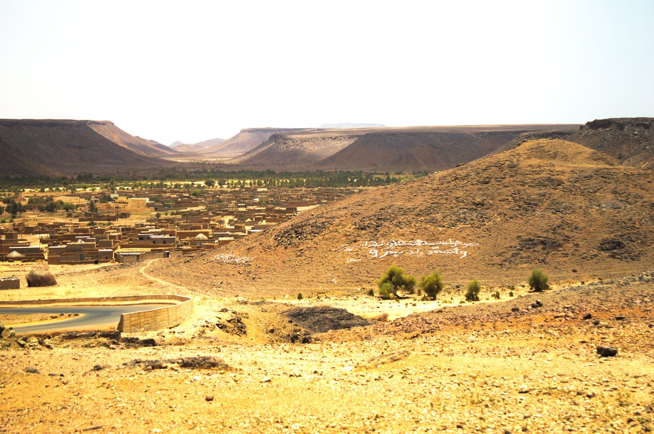
One more real fact gets pulled into the Atlantis story, and it deserves careful handling because it is true. The Sahara has not always been the Sahara. The desert has been hyper-arid for only about the last 5,000 years, and the Eye's visibility today is partly a gift of that dryness: with almost no vegetation or soil to hide it, the bare rock rings read cleanly from space in a way they never would under grassland. The modern desert is the perfect display case for a very old structure.
Go back far enough and there really was water here. During the African Humid Period, roughly 11,000 to 5,000 years ago and documented in the ocean-sediment record by deMenocal and colleagues in 2000, the Sahara caught far more rain than it does now. Paleolakes and rivers spread across the region, the country around the Richat Structure included, and the landscape was genuinely more habitable than the bare rock a visitor finds today. The climate science is solid. What stays speculative is the distance between a wetter Sahara and anything actually happening at this particular dome.
And here the trail simply ends. No archaeological evidence of significant human settlement has ever been found at the Richat Structure itself. Not a wall, not a foundation, not a town. The connection between the green Sahara and the Eye is one that alternative-history proponents assert, but it has no archaeological support of any kind. A wetter regional climate thousands of years ago is a fact about the Sahara. It is not, on its own, evidence that anyone lived, built, or drowned inside the rings.
05So, Is It Atlantis?
Now the claim that brought most people here. The Eye of the Sahara has been proposed as the real location of Plato's Atlantis, and the idea has genuine reach. It was carried to a large online audience above all by the YouTube channel Bright Insight, and the pull is easy to understand. Look again at the orbital photograph: concentric rings, a circular plan, a lost-looking place in the middle of nowhere. Plato described concentric rings. The resemblance is real, and it deserves to be tested properly rather than waved away. So let us test it.
[UNSUPPORTED] The proposal that the Eye of the Sahara is the site of Plato's Atlantis rests on one thing, a superficial visual likeness, and it collapses on contact with the structure's own facts. The Eye sits about 400 meters above sea level and has been dry land since the Paleozoic, hundreds of millions of years before Plato, so there is no moment in human history when it could have sunk beneath the sea. There is no evidence of human construction, habitation, or modification anywhere on it. Its rings are geological rock units, the exposed edges of tilted strata, not artificial channels cut for ships. Its dimensions do not match Plato's description. And Plato's Atlantis is, in the reading most classicists hold, a literary construct in the first place. Point by point, the only thing that matches is the picture.
The scholarship points the same way. The Richat-as-Atlantis proposal, popular as it is online, has no support among classical scholars. Christopher Gill, in his study The Atlantis Story (Routledge, 2017), argues that Plato uses Atlantis deliberately as a literary and philosophical thought experiment across the Timaeus and Critias dialogues, not as a geographical report to be matched against a map. And the Eye is missing everything Plato said Atlantis had: the concentric harbors, the canal systems, the metalwork, the urban infrastructure. There are no ruins to find because nothing was ever built. Our full file on Atlantis weighs Plato's text, the fiction-or-memory debate, and every rival location in depth, the Eye among them. Here the point is narrower and firmer: this specific structure fails the specific test.
| What Plato's Atlantis Has | What The Eye Of The Sahara Is |
|---|---|
| A drowned island, swallowed by the sea in a day | Dry land about 400 m up, above water since the Paleozoic |
| Concentric harbors and ship canals cut by hand | Concentric rings of solid rock, laid bare by erosion |
| A built city: walls, temples, metalwork, streets | No trace of construction, habitation, or modification |
| The scale and layout Plato specified | Dimensions that do not match Plato's account |
| Read literally, a real lost empire | Read by classicists as Plato's literary thought experiment |
Fast Facts
- Real Name
- The Richat Structure (Guelb er Richat)
- Where
- Adrar Plateau, west-central Mauritania
- Size
- About 40 to 50 km across; inner core about 3 km
- What It Is
- A deeply eroded magmatic dome, probably a laccolith or diapir
- Age
- Intrusions dated to about 99 million years (Late Cretaceous)
- Elevation
- About 400 m above sea level, dry land since the Paleozoic
- Impact Origin
- Proposed in 1974, ruled out by 2005; no shock evidence
- Atlantis Claim
- Unsupported; popularized by the Bright Insight YouTube channel
What We Can Actually Stand Behind
The Eye is real and fully explained. It is a circular, deeply eroded magmatic dome about forty to fifty kilometers across, on the Adrar Plateau in Mauritania, with intrusions dated to roughly 99 million years ago. Its rings are the eroded edges of tilted rock, produced by ordinary differential erosion. An early impact-crater hypothesis was tested and ruled out: no shocked quartz, no shatter cones, no high-pressure minerals, no impact chemistry. On the geology, the case is closed.
The live scientific questions at the Eye are about its magma. Whether the dome records one uplift or several, and why alkaline and calc-alkaline rocks sit together in one complex, are real and unsettled research problems. None of them hint at Atlantis. The frontier here is petrology, not archaeology.
The green Sahara was real. During the African Humid Period the region held lakes and rivers and was far more habitable than today. But no archaeological evidence of significant settlement has ever been found at the Eye itself, and a wetter Sahara thousands of years ago is not evidence that anyone lived or built inside the rings.
The Eye of the Sahara is not Atlantis. It has been dry land about four hundred meters above the sea since the Paleozoic, so it never sank. There is no construction, no canal, no metalwork, no city. Its rings are rock, not harbors, its scale does not match Plato, and classicists read Atlantis as a literary invention to begin with. The resemblance is a picture, and only a picture.
Which leaves the one honest question the rock cannot answer. Every hard part of this was solved long ago. We know what the Eye is made of, how old it is, how it formed, and why it looks the way it does, and we know, just as firmly, what it is not. And yet a fully explained, entirely natural dome still draws a larger and more devoted online audience for the Atlantis claim than for the true story of how it came to be. The satellites settled the geology. They did nothing to settle us. So the question that stays open is not about the desert at all: when a mystery has been completely explained, why do so many of us still need it to be a lost city, and what would it take for the real answer to be the one that travels?
Sources & further reading
Everything above is drawn from our research library on Theories of Anything, which is where we worked from. The papers, reports and primary records listed beneath them are where you can check us independently.
Image credits
- An orbital photograph of the Richat Structure in the Sahara Photo: NASA, Image Science & Analysis Laboratory, Johnson Space Center. Public domain
- A 1965 photograph of the Richat Structure taken from the Gemini IV spacecraft Photo: NASA / Gemini IV mission. Public domain
- A settled oasis town in a valley on the Adrar Plateau of central Mauritania Photo: Ammar Hassan. CC BY 2.0 Source.
- Card crop of an orbital photograph of the Richat Structure in the Sahara Photo: NASA, Image Science & Analysis Laboratory, Johnson Space Center. Public domain
.jpg)