The Universal Deluge: Mapping the World's Flood Memories
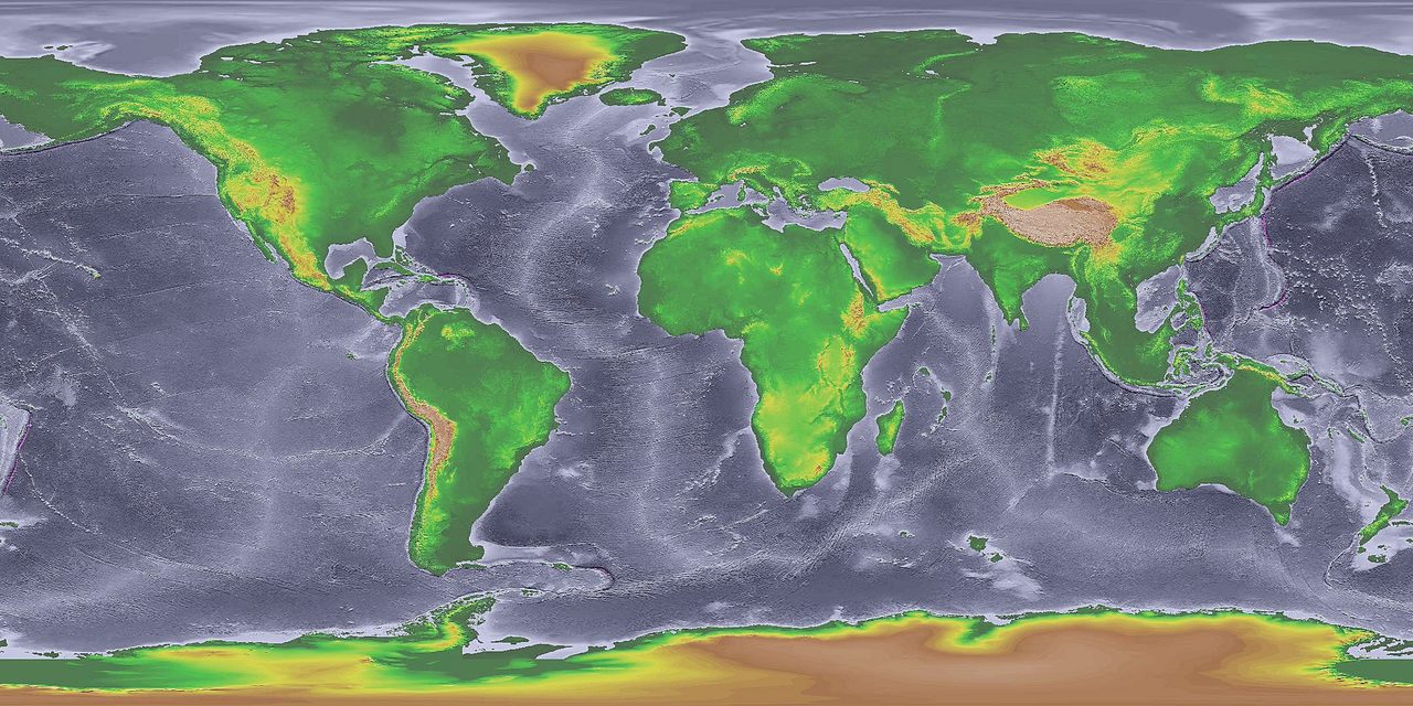
Between the Last Glacial Maximum and roughly 6,000 years ago, the oceans rose about 120 meters and rewrote every coastline on Earth. Whole inhabited lands went under: Doggerland beneath the North Sea, Sundaland across Southeast Asia, the dry floor of the Persian Gulf. In that same window, hundreds of peoples on every inhabited continent kept telling the same kind of story, a world drowned and a remnant saved. This dossier lays the geology against the map. It is not a retelling of the flood myths themselves, which this wing's survey already owns, but the harder question underneath them: the water was real, and the lost coastlines are real, so does the physical record prove that any single deluge is the flood behind the world's flood memories, or does an honest map have to keep those two truths apart?
Start with what is not in dispute. The end of the last ice age was, among other things, a planetary flood in slow motion, and it happened inside the span of human occupation. That single fact is where this file lives. The other half of the subject, the flood texts themselves across Mesopotamia, the Bible, India, China, and Greece, already has its own home in this wing's flood-myth survey, and does not need repeating here. This dossier does the geology and the map instead: the sea-level curves, the abrupt meltwater pulses, and the drowned landmasses, set against the worldwide spread of the traditions, and it refuses to let the two blur into one.
Keep one distinction in hand for everything that follows, because it is the whole argument. There is the physical claim, that seas rose and coastlines drowned, which the peer-reviewed record settles cleanly. And there is the causal claim, that a particular one of those floods is the specific origin of a particular myth, or of all of them at once. The first is Tier 1 science. The second is where the evidence thins, splits, and in one case collapses entirely. Every section below wears the tier the research file assigns it, and the gap between those two kinds of claim is the point of the piece.
01The Water Was Real
The number that anchors everything: global sea levels rose about 120 meters between the Last Glacial Maximum, roughly 20,000 years ago, and about 6,000 years ago. That is not a gentle drift. The research file flags its own key finding right here, that the steepest rises came in sudden surges called meltwater pulses, and Meltwater Pulse 1A alone lifted the oceans about 20 meters in roughly 500 years. Kurt Lambeck and colleagues (2014) documented that the flooding during those surges swallowed vast stretches of continental shelf, and the file names the casualties directly: Doggerland, Sundaland, and the Persian Gulf basin. This is the load-bearing fact of the whole subject, and it is Tier 1.
Here the numbers need daylight, because two sibling files in this wing put a date on that same pulse and do not agree. This research document, citing Lambeck and colleagues (2014), places Meltwater Pulse 1A at roughly 14,600 years before the present. The wing's flood-myth survey, citing the same 2014 study, places it instead at roughly 14,600 BCE. Those two figures look identical and are not the same date. Years before the present are counted back from today, while years BCE are counted back from the year 1, and the roughly 2,000 years elapsed since then sit between the two conventions: converted onto one calendar, 14,600 BCE lands near 16,600 years before the present, about 2,000 years earlier than a pulse dated to 14,600 years ago. We flag that gap rather than quietly pick a side. The event itself is real, abrupt, and firmly in the peer-reviewed record, but the exact calendar date these two files carry for it disagrees by roughly two millennia, and that disagreement is not yet reconciled.
Set that caveat aside and the physical picture is unambiguous. Ice sheets that had locked up the water for tens of thousands of years let it go, sometimes inside a few centuries, and the sea came inland far enough to erase places people were living. The map of where it erased them is the next section.
02Three Coastlines That Drowned
Three of those drowned places do the real work in this file, because they are the only spots where the research document names a submerged landmass and a human consequence in the same breath. Sundaland has its own dedicated dossier in the Lost Worlds wing, and Doggerland's own end is told there through a related dossier on the event that finished it, both cross-linked rather than re-derived here. The third, the Persian Gulf basin, is where this article can push hardest, because it carries a flood-origin hypothesis that no sibling file already owns.
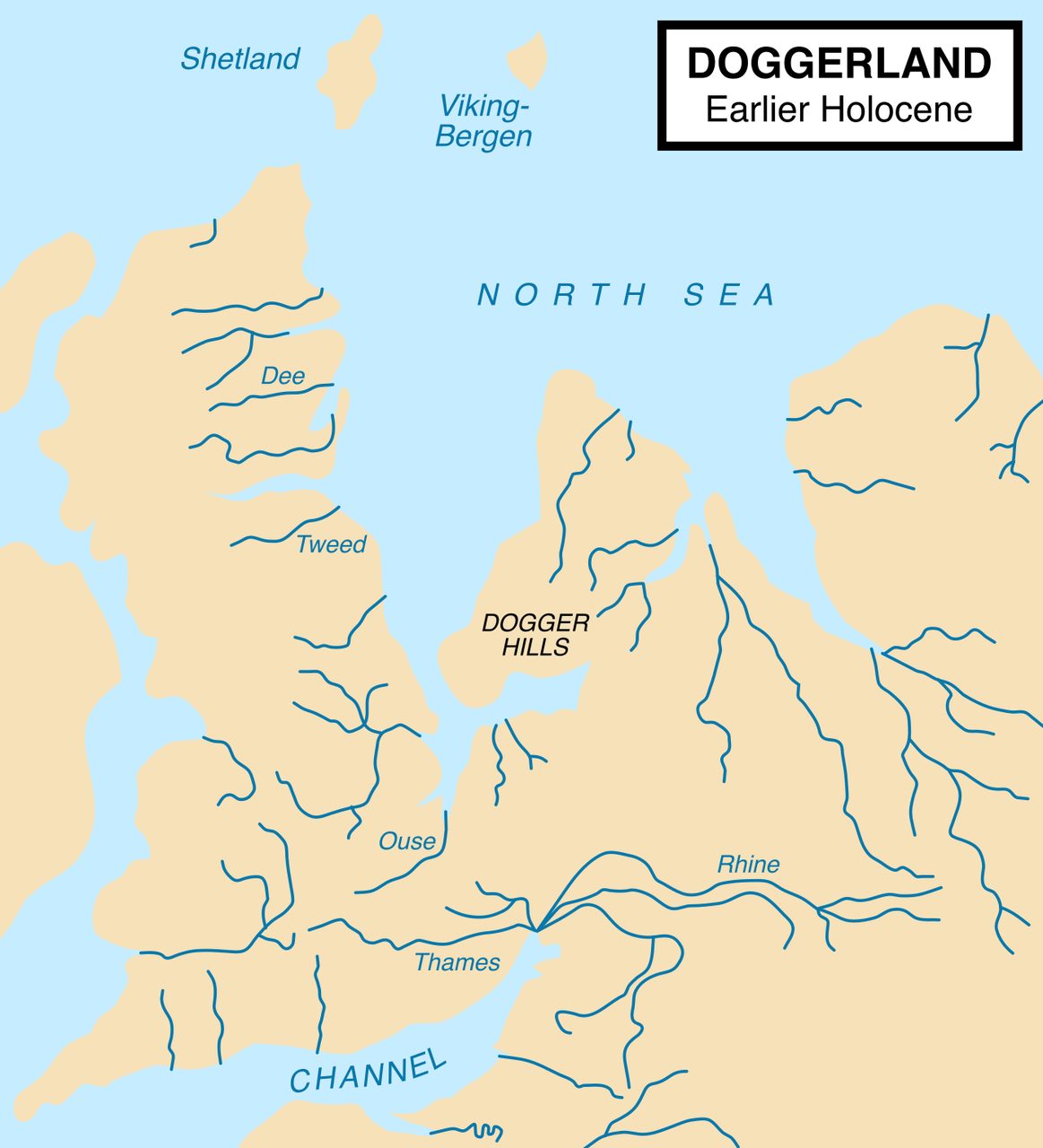
Doggerland is the cleanest proof that a lost world can be literal. It was a real, inhabited lowland plain that once joined Britain to continental Europe, and the rising post-glacial sea drowned it, leaving it beneath the southern North Sea. The research file names it directly as one of the three regions the meltwater pulses took. It is documented ground, not legend: whole homelands genuinely vanished under the water within the span of human occupation.
The later, sharper drowning of that same region has its own Lost Worlds dossier in the Storegga Slide. This file keeps only the headline, that Doggerland was real and that it is gone, and lets the geology of its end be told there.
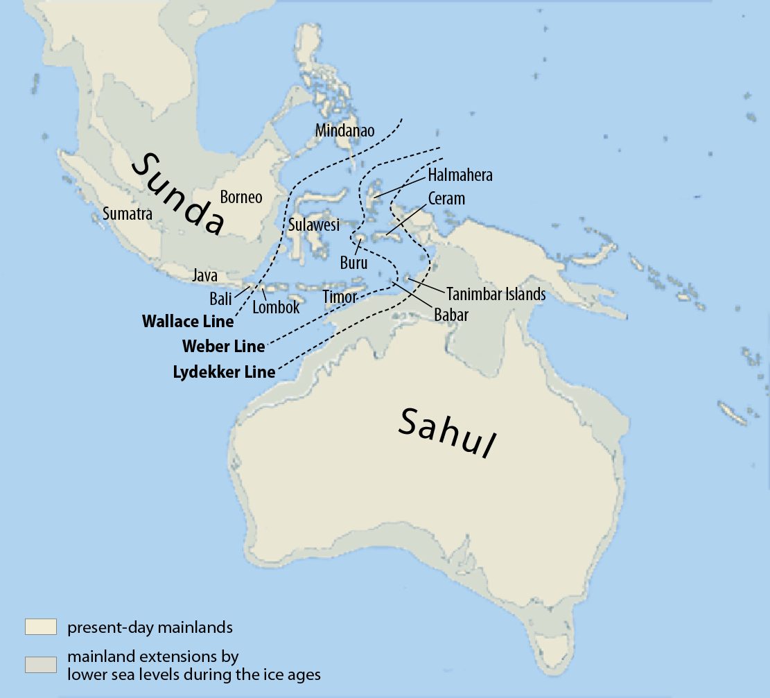
Sundaland is the same story at continental scale. During the ice age the Southeast Asian shelf, Borneo, Sumatra, Java, and Palawan, stood joined to the Asian mainland as dry land, and the post-glacial seas drowned it into the islands we see now. The research file names Sundaland as the second of its three flooded regions. The land loss here was vast, and it emptied coastlines that people were living on, on the far side of the world from Mesopotamia.
Sundaland's own geology, and the argument over what its drowning meant for the people displaced by it, is the subject of the Lost Worlds wing's dedicated Sundaland dossier. This file cross-links it rather than re-deriving it, and keeps only the mapping point: a continent-sized shelf went under.
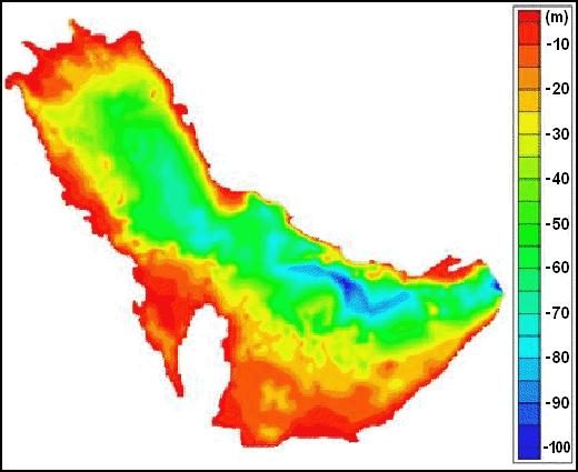
The Persian Gulf is where the geology gets genuinely provocative, and where the file lets an origin hypothesis onto the table. Jeffrey Rose (2010) proposed that the Gulf was not always a sea. During the last ice age its basin was a dry, potentially habitable lowland, and it flooded between roughly 8,000 and 6,000 years ago as the rising ocean poured in. Rose argued this 'Gulf Oasis' could have supported a real population whose displacement seeded the Mesopotamian flood traditions, and he pointed to the basin's geography and the timing of the earliest Ubaid settlements along the new Gulf coast as support. It is a strong, on-the-map idea, and the file holds it exactly where it belongs: Tier 3, speculative, because direct archaeological evidence from the drowned basin floor itself is still thin.
This is the one flooded landmass in the file with a flood-origin claim attached to it that no sibling article already owns, which is why it earns the most room here. It is also a clean example of the article's whole discipline: a real, datable inundation of a real basin, paired with a causal story about a specific myth that the evidence can suggest but cannot yet demonstrate.
| Region | Where It Was | What The Record Documents | Proposed Flood-Myth Link | Tier |
|---|---|---|---|---|
| Doggerland | The southern North Sea, joining Britain to continental Europe | An inhabited lowland plain submerged as the post-glacial seas rose | Named as documented submergence; no specific myth-origin claim in the source | 1 (the submergence) |
| Sundaland | The Southeast Asian shelf: Borneo, Sumatra, Java, Palawan | A continent-sized shelf drowned as seas climbed after the Last Glacial Maximum | Named as documented submergence; oral-memory transmission debated, not established | 1 (the submergence) |
| Persian Gulf basin | The floor of the present Gulf, below sea level | A dry, potentially habitable basin flooded roughly 8,000 to 6,000 years ago | Rose's 'Gulf Oasis': a displaced population may underlie Mesopotamian flood traditions | 3 |
03Hundreds Of Floods, One Pattern
So the seas rose and the coastlines drowned. The other half of the correlation is the stories, and they enter the written record with Mesopotamia. The oldest written flood traditions we have are Sumerian and Akkadian: the Eridu Genesis names Ziusudra, the Atrahasis epic ties the flood to human overpopulation, and Tablet XI of Gilgamesh preserves the best-kept version of the three. When George Smith of the British Museum read that Assyrian tablet aloud to the Society of Biblical Archaeology in 1872 and showed the world a flood narrative older than Genesis by more than a thousand years, it caused an international sensation. That whole discovery, and the Gilgamesh flood in full, belongs to the wing's Utnapishtim's Ark dossier; here it is only the anchor point, the moment the written flood record was proven to run deeper than the Bible.
Then the pattern widens far past Mesopotamia, and this is where the counts get slippery on purpose. Alan Dundes (1988) catalogued flood narratives from hundreds of cultures and found the same skeleton recurring: a divine or cosmic warning, a moral cause in human corruption, a single righteous family saved, animals preserved, a mountain as the landing point, and a covenant or renewal at the end. Crucially, the motif turns up in traditions with no demonstrated contact with Mesopotamia at all, Aboriginal Australian, Native American (Hopi, Ojibwe, Caddo), Andean. The file grades this Tier 2, credible and debated, and it carries its own strongest counter: John Greenway argued that some 'universal' flood myths were introduced or reshaped by Christian missionaries during the colonial era, quietly contaminating the very corpus that looks so uniform.
How many such traditions there are depends on who is counting and what counts as one. The tallies in the literature run to the hundreds, and this wing's own flood-myth survey catalogs the traditions themselves in detail. What matters for a mapping file is not the exact tally but the shape: the same story, told hundreds of times, on every inhabited continent, by peoples who in many cases never met.
That shape forces the real interpretive question, and the scholars who study it have not settled it. One camp reads the Mesopotamian narrative as the ultimate source, spreading outward along trade and cultural contact until it reached the edges of the map. The other argues for polygenesis: many independent traditions, each rising from a local flood a real community actually survived. Dundes himself split the difference, favoring diffusion for the Near Eastern and Mediterranean traditions while granting independent origin to the geographically remote ones. The Hindu Manu narrative sits right on that fault line, a fish warning a righteous man to build a boat before the waters come: Wendy Doniger reads it as developing independently of Mesopotamian influence, while Stephanie Dalley notes a possible route of transmission through Indo-Iranian contact. A geography-first reading does not get to pick a winner here. It gets to see clearly why the question is hard.
There is one more thing a mapping file has to confront, because it decides whether the whole correlation is even possible. If a flood that drowned a coastline 8,000 years ago is the seed of a story told today, the memory had to survive that long without writing. Patrick Nunn (2018) has argued that it can, documenting Australian Aboriginal accounts that appear to preserve accurate knowledge of post-glacial coastal change across as much as 10,000 years. Skeptics answer that this far exceeds the fidelity oral transmission can plausibly hold without a written anchor. The research file leaves that debate open, and so does this article: if the seas really are the source of the stories, human memory is doing something remarkable, and whether it can is not yet proven either way.
04The Named Catastrophes
If a real flood is going to be crowned as the flood, it has to be a specific, named event, and two candidates dominate the argument. Both are real geological episodes. Neither has been shown to be the origin of any specific myth, and each is owned in depth by a Lost Worlds dossier this file cross-links rather than re-litigates.
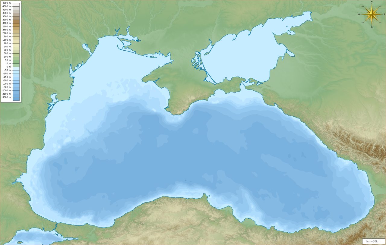
The Black Sea Deluge Hypothesis is the most famous candidate. William Ryan and Walter Pitman (1998) proposed that around 5600 BCE the Mediterranean breached the Bosporus and poured into what was then a freshwater Black Sea basin, drowning former shoreline and driving farming communities inland. Robert Ballard (2000) later found well-preserved wooden structures and freshwater mollusk shells on the deep sea floor, which read as rapid inundation. The file grades it Tier 2, and it is genuinely contested: Ali Aksu and colleagues (2002) and Liviu Giosan and colleagues (2009) argue the flow was gradual rather than catastrophic, with Black Sea levels already rising before the breach. The full Ryan-Pitman debate is the subject of the Lost Worlds wing's Megaflood Country dossier; this file keeps it brief on purpose.
The second candidate reaches further back and further out. The Younger Dryas impact hypothesis proposes that a cosmic impact or airburst around 12,800 years ago triggered massive flooding from glacial lake outbursts, notably the collapse of Lake Agassiz, which living populations could in principle have witnessed. Graham Hancock and others have argued that the world's flood myths preserve the memory of that event. Here the tiers have to be kept apart carefully. The Younger Dryas cooling itself is well documented, an abrupt cold snap around 12,800 years before present, but the link from it to any specific flood myth remains undemonstrated in the peer-reviewed literature, and the myth-memory version of the claim traces to a popular author rather than to a refereed source. Tier 3, and no higher. The impact hypothesis itself is argued in full in the Lost Worlds wing's Younger Dryas Impact dossier.
Fast Facts
- The Sea-Level Rise
- Global sea levels rose about 120 meters between the Last Glacial Maximum, roughly 20,000 years ago, and about 6,000 years ago (Lambeck and colleagues, 2014). The steepest surges were the meltwater pulses; Meltwater Pulse 1A alone raised the oceans about 20 meters in roughly 500 years.
- The Date That Does Not Match
- This research file dates Meltwater Pulse 1A to roughly 14,600 years before the present; the wing's flood-myth survey, citing the same 2014 study, dates it to roughly 14,600 BCE. Because BCE is counted from the year 1, those differ by about 2,000 years on one calendar. The pulse is real; the two files' dates for it are not yet reconciled.
- The Three Drowned Lands
- The research file names Doggerland (the North Sea plain joining Britain to Europe), Sundaland (the Southeast Asian shelf), and the Persian Gulf basin as regions the post-glacial seas swallowed.
- The Gulf Oasis
- Jeffrey Rose (2010) proposed the Persian Gulf was a dry, habitable basin that flooded roughly 8,000 to 6,000 years ago, possibly displacing a population that seeded Mesopotamian flood traditions. Tier 3: geographically plausible, archaeologically thin.
- The Worldwide Pattern
- Alan Dundes (1988) catalogued flood narratives from hundreds of cultures on every inhabited continent, sharing a recurring structure, including in traditions with no demonstrated Mesopotamian contact. Tier 2, with a real counter: some may have been reshaped by colonial-era missionaries (Greenway).
- The Oldest Written Version
- The oldest written flood traditions are Sumerian and Akkadian (Ziusudra in the Eridu Genesis, the Atrahasis epic, Gilgamesh Tablet XI). George Smith read the Assyrian tablet publicly in 1872, proving a flood narrative older than Genesis.
- The Line That Cannot Be Crossed
- A literal worldwide flood around 4,000 years ago is ruled out. No global flood layer exists in the stratigraphic record, and genetic evidence shows continuous population lineages far older than any proposed flood date.
What The Evidence Actually Holds
The physical flood is real and it is Tier 1. Global sea levels rose about 120 meters between the Last Glacial Maximum and roughly 6,000 years ago, and the steepest rises came in abrupt meltwater pulses (Lambeck and colleagues, 2014). Real, inhabited landmasses drowned: Doggerland beneath the North Sea, Sundaland across Southeast Asia, and the Persian Gulf basin. The Mesopotamian traditions are genuinely the oldest written flood narratives, and George Smith proved as much in 1872. One honest caveat rides on the dates: this file puts Meltwater Pulse 1A at roughly 14,600 years before the present while the wing's survey puts it at roughly 14,600 BCE, and those differ by about 2,000 years, a gap between the two files that is not yet reconciled.
Two claims sit at credible but debated. The Black Sea Deluge Hypothesis (Ryan and Pitman, 1998; wooden structures and freshwater mollusks found by Ballard, 2000) is a serious proposal for a catastrophic Bosporus breach around 5600 BCE, but Aksu and colleagues (2002) and Giosan and colleagues (2009) make a strong case that the flooding was gradual instead. And the worldwide structural pattern is real: Dundes (1988) documented flood narratives from hundreds of cultures sharing one skeleton, including in traditions with no demonstrated Mesopotamian contact, though Greenway's counter, that colonial-era missionaries reshaped part of the corpus, has to be reckoned with.
Two flood-origin hypotheses stay speculative, exactly where the file grades them. Jeffrey Rose's (2010) 'Gulf Oasis', a dry Persian Gulf basin flooding roughly 8,000 to 6,000 years ago and displacing a population that may have seeded Mesopotamian flood memory, is geographically plausible but archaeologically thin. And the idea, associated with Graham Hancock and others, that global flood myths preserve the memory of Younger Dryas flooding around 12,800 years ago is undemonstrated in the peer-reviewed literature; the cooling event is real, the myth-memory link is not established. Tier 3, both of them.
A literal worldwide flood, the kind that covers every mountain at once a few thousand years ago: no. The research file marks it debunked in its own text, and this article rules it out with it. There is no global flood layer anywhere in the stratigraphic record. Genetic evidence shows continuous human population lineages far older than any proposed flood date. It is, in the file's own words, geologically impossible as described in literal interpretations. The seas really did rise, and real coastlines really did drown, but no single deluge covered the Earth, and none has been shown to be the one flood that started the world's flood stories. The physical record is extraordinary on its own terms. It does not need to be the Flood, and it is not.
Stand back and the two halves refuse to snap together. On one side, the hardest kind of evidence: oceans up about 120 meters, whole homelands under the sea, all of it inside the time humans were watching. On the other, hundreds of peoples on every inhabited continent telling the same drowned-world story. The temptation to draw one line from one flood to all of them is enormous, and the honest reading of the record will not allow it. So the question this dossier leaves open is the sharp one, not the easy one. If the seas really did swallow Doggerland and Sundaland and the floor of the Persian Gulf within human memory, and hundreds of cultures really do remember a flood, what would it actually take to prove that those are the same fact, and would proving it change what any of those peoples were trying to say when they told the story?
Sources & further reading
Everything above is drawn from our research library on Theories of Anything, which is where we worked from. The papers, reports and primary records listed beneath them are where you can check us independently.
Image credits
- Global sea levels during the last Ice Age, NOAA / National Geophysical Data Center U.S. National Oceanic and Atmospheric Administration (NOAA/NGDC), via Wikimedia Commons. Public domain Source.
- Map of Doggerland, the submerged landmass connecting Britain to continental Europe map by Max Naylor, via Wikimedia Commons. CC BY-SA 3.0 / GFDL Source.
- Map of Sunda and Sahul, the connected ice-age landmasses of Southeast Asia and Australia-New Guinea map by Maximilian Dörrbecker (Chumwa), via Wikimedia Commons. CC BY-SA 3.0 Source.
- Bathymetric and relief map of the Black Sea map by Giorgi Balakhadze, via Wikimedia Commons. CC BY-SA 4.0 Source.
- Bathymetric map of the Persian Gulf map by Wikimedia Commons user Orijentolog, via Wikimedia Commons. CC BY-SA 3.0 Source.
- Card crop of Global sea levels during the last Ice Age, NOAA / National Geophysical Data Center U.S. National Oceanic and Atmospheric Administration (NOAA/NGDC), via Wikimedia Commons. Public domain Source.


